The Souhegan River is a tributary of the Merrimack River in the northeastern United States. It is 33.8 miles (54.4 km) long with a drainage area of 171 sq mi (440 km2) and flows north and east through southern New Hampshire to the Merrimack River.

The Arkansas River is a major tributary of the Mississippi River. It generally flows to the east and southeast as it traverses the U.S. states of Colorado, Kansas, Oklahoma, and Arkansas. The river's source basin lies in the western United States in Colorado, specifically the Arkansas River Valley, where the headwaters derive from the snowpack in the Sawatch and Mosquito mountain ranges. It then flows east into the Midwest via Kansas, and finally into the South through Oklahoma and Arkansas.

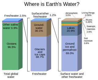
The terms international waters or trans-boundary waters apply where any of the following types of bodies of water transcend international boundaries: oceans, large marine ecosystems, enclosed or semi-enclosed regional seas and estuaries, rivers, lakes, groundwater systems (aquifers), and wetlands.

In geography and fluvial geomorphology, a thalweg or talweg is the line of lowest elevation within a valley or watercourse.
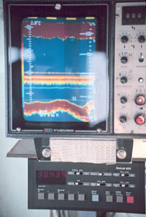
A fishfinder or sounder (Australia) is an instrument used to locate fish underwater by detecting reflected pulses of sound energy, as in sonar. A modern fishfinder displays measurements of reflected sound on a graphical display, allowing an operator to interpret information to locate schools of fish, underwater debris, and the bottom of body of water. Fishfinder instruments are used both by sport and commercial fishermen. Modern electronics allows a high degree of integration between the fishfinder system, marine radar, compass and GPS navigation systems.

The Pedder galaxias is an Australian freshwater fish. It is considered to be extinct in the wild since 2005 by the EPBC Act, and was originally found only in Lake Pedder in Tasmania.

The public trust doctrine is the principle that the sovereign holds in trust for public use some resources such as shoreline between the high and low tide lines, regardless of private property ownership.

Lake Tapps is a reservoir in Pierce County, Washington. It was created in 1911 by Puget Sound Energy and operated for hydroelectric power until it ceased power production in 2004. In December 2009 PSE sold the reservoir to the Cascade Water Alliance, a municipal corporation whose members are five King County cities and two water and sewer districts. Cascade provides drinking water to more than 350,000 residents and more than 20,000 businesses. It plans to eventually use Lake Tapps as a municipal water supply source for customers of its members.
The Upper Colorado River Endangered Fish Recovery Program is a multi-agency partnership to recover endangered fish in the upper Colorado River basin while water development proceeds in compliance with state and federal law.
Pilarcitos Creek is a 13.5-mile-long (21.7 km) coastal stream in San Mateo County, California, United States, that rises on the western slopes of the Santa Cruz Mountains and descends through Pilarcitos Canyon to discharge into the Pacific Ocean Half Moon Bay State Beach.
The Hawaiʻi Department of Land and Natural Resources (DLNR) is a part of the Hawaiʻi state government dedicated to managing, administering, and excerising control over public lands, water resources and streams, ocean waters, coastal areas, minerals, and other natural resources of the state of Hawaiʻi. The mission of the Hawaiʻi Department of Land and Natural Resources is to "enhance, protect, conserve and manage Hawaiʻi's unique and limited natural, cultural and historic resources held in public trust for current and future generations of the people of Hawaiʻi nei, and its visitors, in partnership with others from the public and private sectors." The organization oversees over 1.3 million acres of land, beaches, and coastal waters and 750 miles of coastal land.
The Oregon Water Trust (OWT), now operating as The Freshwater Trust, is an environmental organization based in the U.S. state of Oregon. Its mission is to restore surface water flows for healthier streams in Oregon by using cooperative, free-market solutions. OWT was founded in 1993 by a group with diverse water interests who sought to utilize the "tools of the land trust movement...and apply the same approach to the acquisition of water". "With the success of OWT, water trusts have been created in Montana, Colorado, and Washington" with others emerging across the Western United States. Utilizing a transactional approach, the group focuses on streams where small amounts of water provide significant ecological benefits. The result is healthier streams for fish, wildlife, and people.

Piotr Parasiewicz is an Austrian-American river professor, Director of Rushing Rivers Institute, and the creator of the Mesohabitat Simulation Model (MesoHABSIM). He holds a Ph.D in Natural resource management and Water Engineering. He has been working to restore rivers to their natural state and conserve water for human use, including the Quinebaug River, Fort River, Saugatuck River & Aspetuck River, Eightmile River, and Delaware River.
Mesohabitat simulation model (MesoHABSIM), created by Dr. Piotr Parasiewicz addresses the requirements of watershed-based management of running waters and is designed to predict an aquatic community's response to habitat modification.
WEAP is a Windows-based decision support system for integrated water resources management and policy analysis. WEAP is a model-building tool, used to create simulations of water demand, supply, runoff, evapotranspiration, infiltration, crop irrigation requirements, instream flow requirements, ecosystem services, groundwater and surface storage, reservoir operations, and pollution generation, treatment, discharge and instream water quality, all under scenarios of varying policy, hydrology, climate, land use, technology and socio-economic factors. WEAP can dynamically link to the USGS MODFLOW groundwater flow model and the US EPA QUAL2K surface water quality model.

Rushing Rivers Institute is a non-profit organization in the United States directed by Piotr Parasiewicz to implement river science in the preservation of water resources for the environment and human use. The Institute provides on-demand services, integrating physical and ecological sciences, professional training, and project review services to protect and restore rivers.
Low head hydropower applications use tidal flows or rivers with a head of 20 metres (66 ft) or less to produce energy. These applications may not need to dam or retain water to create hydraulic head. Using the drop in a river or tidal flows to create electricity may provide a renewable energy source that will have a minimal impact on the environment.
Partners for Fish and Wildlife is a voluntary partnership program administered by the Fish and Wildlife Service to provide financial and technical assistance to private landowners who wish to protect or restore wetlands, uplands, and riparian and instream habitats. Through 2002, the program entered into nearly 29,000 land owner agreements to protect or restore about 640,000 acres (2,600 km2) of wetlands and almost 1,100,000 acres (4,500 km2) of uplands. This program has been widely used by rural landowners, including farmers.
Colorado Water Trust* (“CWT”) is a non-profit conservation organization based in the state of Colorado. Its mission is to engage in and support voluntary, market-based efforts to restore and protect streamflows using permanent acquisitions of water, leases of water, and physical solutions. CWT is also a resource to Colorado land trusts encountering water issues in connection with their land conservation activities.

The Central Oregon Jobs and Water Security Act is a land-use and water bill related to the Crooked River in Oregon and the Bowman Dam. H.R. 2640 would modify features of the Crooked River Project located in central Oregon, north of the city of Prineville, and prioritize how water from the project would be allocated for different uses. It was introduced into the United States House of Representatives during the 113th United States Congress.