
Interstate 95 (I-95) is the main north–south Interstate Highway on the East Coast of the United States, running from U.S. Route 1 (US 1) in Miami, Florida, north to the Houlton–Woodstock Border Crossing between Maine and the Canadian province of New Brunswick. The highway largely parallels the Atlantic coast and US 1, except for the portion between Savannah, Georgia, and Washington, D.C., and the portion between Portland and Houlton in Maine, both of which follow a more direct inland route.

Interstate 10 (I-10) is the southernmost transcontinental highway in the Interstate Highway System. I-10 is the fourth-longest Interstate in the United States at 2,460.34 miles (3,959.53 km), following I-90, I-80, and I-40. This freeway is part of the originally planned network that was laid out in 1956, and its last section was completed in 1990.

Interstate 81 (I-81) is a north–south Interstate Highway in the eastern part of the United States. Its southern terminus is at I-40 in Dandridge, Tennessee; its northern terminus is on Wellesley Island, New York at the Canadian border, where the Thousand Islands Bridge connects it to Highway 137 and ultimately to Highway 401, the main Ontario freeway connecting Detroit via Toronto to Montreal. The major metropolitan areas along the route of I-81 include the Tri-Cities of Tennessee; Roanoke in Virginia; Hagerstown in Maryland; Harrisburg and the Wyoming Valley in Pennsylvania; and Binghamton and Syracuse in New York.

Interstate 90 (I-90) is an east–west transcontinental freeway and the longest Interstate Highway in the United States at 3,021 miles (4,862 km). It begins in Seattle, Washington, and travels through the Pacific Northwest, Mountain West, Great Plains, Midwest, and the Northeast, ending in Boston, Massachusetts. The highway serves 13 states and has 15 auxiliary routes, primarily in major cities such as Chicago, Cleveland, Buffalo, and Rochester.

Interstate 94 (I-94) is an east–west Interstate Highway connecting the Great Lakes and northern Great Plains regions of the United States. Its western terminus is just east of Billings, Montana, at a junction with I-90; its eastern terminus is in Port Huron, Michigan, where it meets with I-69 and crosses the Blue Water Bridge into Sarnia, Ontario, Canada, where the route becomes Ontario Highway 402. It thus lies along the primary overland route from Seattle to Toronto and is the only east–west Interstate Highway to have a direct connection to Canada.

Interstate 43 (I-43) is a 191.55-mile-long (308.27 km) Interstate Highway located entirely within the US state of Wisconsin, connecting I-39/I-90 in Beloit with Milwaukee and I-41, U.S. Highway 41 (US 41) and US 141 in Green Bay. State Trunk Highway 32 (WIS 32) runs concurrently with I-43 in two sections and I-94, I-894, US 10, US 41, US 45, and WIS 57 overlap I-43 once each. There are no auxiliary or business routes connected to I-43, though an alternate route to direct traffic during road closures is signed along local and state highways from Milwaukee County north into Brown County.

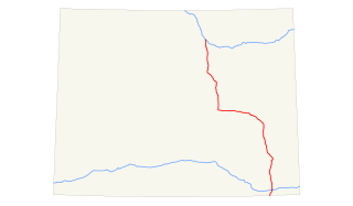
U.S. Route 212 (US 212) is a spur of US 12. It runs for 949 miles (1,527 km) from Yellowstone National Park to Minnesota Highway 62 at Edina, Minnesota. It does not intersect US 12 now, but it once had an eastern terminus at US 12 in St. Paul, Minnesota. US 212 passes through the states of Minnesota, South Dakota, Wyoming, and Montana. It goes through the cities of Watertown, South Dakota and Billings, Montana.

Interstate 84 (I-84) is an Interstate Highway in the Northeastern United States that extends almost 233 miles from Dunmore, Pennsylvania, near Scranton at an interchange with I-81 east to Sturbridge, Massachusetts, at an interchange with the Massachusetts Turnpike (I-90). Among the major cities that the road passes through is Hartford, Connecticut, and the road provides a major portion of the primary route between New York City and Boston. Another highway named I-84 is located in the Northwestern United States.

Interstate 88 (I-88) is an Interstate Highway located entirely within the US state of New York. Nominally signed as an east–west road as it has an even number, it extends for 117.75 miles (189.50 km) in a northeast–southwest direction from an interchange with I-81 north of the city of Binghamton to an interchange with the New York State Thruway (I-90) west of Schenectady. The freeway serves as an important connector route from the Capital District to Binghamton, Elmira, and Scranton, Pennsylvania. I-88 closely parallels NY 7, which was once the main route through the area.
Interstate 310 (I-310) is a short spur route of I-10 west of New Orleans, located entirely in St. Charles Parish, Louisiana. It begins at a point on I-10 just west of Louis Armstrong New Orleans International Airport and the city of Kenner. It travels southward as an elevated freeway across the LaBranche Wetlands and intersects U.S. Route 61 (US 61) in St. Rose. The highway crosses the Mississippi River from Destrehan to Luling via the Hale Boggs Memorial Bridge. After a brief concurrency with Louisiana Highway 3127 (LA 3127), I-310 terminates at US 90 in Boutte.
Interstate 510 (I-510) is a short spur route of I-10 within eastern New Orleans, Louisiana, United States. It runs south from I-10, intersects with U.S. Route 90, and ends at the Almonaster Boulevard interchange, near the NASA Michoud Assembly Facility. From this point, the highway continues south over the Gulf Intracoastal Waterway / Mississippi River Gulf Outlet on the Green Bridge.
Interstate 190 is a north–south auxiliary Interstate Highway in the United States that connects I-90 in Buffalo, New York, with the Canada–United States border at Lewiston, New York, near Niagara Falls. Officially, I-190 from I-90 north to New York State Route 384 (NY 384) is named the Niagara Thruway and is part of the New York State Thruway system. The remainder, from NY 384 to Lewiston, is known as the Niagara Expressway and is maintained by the New York State Department of Transportation (NYSDOT).

Interstate 80 (I-80) in the US state of Pennsylvania runs for 311.12 miles (500.70 km) across the central part of the state. It is designated as the Keystone Shortway and officially as the Z.H. Confair Memorial Highway. This route was built mainly along a completely new alignment, not paralleling any earlier US Routes, as a shortcut to the tolled Pennsylvania Turnpike to the south and New York State Thruway to the north. It does not serve any major cities in Pennsylvania and is mainly a cross-state route on the Ohio–New York City corridor. Most of I-80's path across the state goes through hilly and mountainous terrain, while the route passes through relatively flat areas toward the western part of the state.
Interstate 10 (I-10), a major transcontinental Interstate Highway in the Southern United States, runs across the southern part of Louisiana for 274.42 miles (441.64 km) from Texas to Mississippi. It passes through Lake Charles, Lafayette, and Baton Rouge, dips south of Lake Pontchartrain to serve the New Orleans metropolitan area, then crosses Lake Pontchartrain and leaves the state.

The Vieux Carré Riverfront Expressway was a controversial, mostly-elevated, never-built freeway that would have cut through the French Quarter of New Orleans, Louisiana. From 1964 to 1969, it was also designated Interstate 310 (I-310).

Interstate 10 (I-10) is a part of the Interstate Highway System that runs from Santa Monica, California, to Jacksonville, Florida. In Alabama, the Interstate Highway runs 66.269 miles (106.650 km) from the Mississippi state line near Grand Bay east to the Florida state line at the Perdido River. I-10 is the primary east–west highway of the Gulf Coast region of Alabama. The highway connects Mobile, the largest city in South Alabama, with Pascagoula, Mississippi, to the west and Pensacola, Florida, to the east. Within the state, the highway connects Mobile and Mobile County with the Baldwin County communities of Daphne and Fairhope. I-10 connects Mobile and Baldwin County by crossing the northern end of Mobile Bay and the southern end of the Mobile-Tensaw River Delta via the George Wallace Tunnel in Mobile and the Jubilee Parkway viaduct system between Mobile and Daphne.
Interstate 90 (I-90) is a part of the Interstate Highway System that runs from Seattle, Washington, to Boston, Massachusetts. In the US state of New York, I-90 extends 385.48 miles (620.37 km) from the Pennsylvania state line at Ripley to the Massachusetts state line at Canaan, and is the second-longest highway in the state after New York State Route 17 (NY 17). Although most of the route is part of the tolled New York State Thruway, two non-tolled sections exist along I-90. Within New York, I-90 has a complete set of auxiliary Interstates, which means that there are Interstates numbered I-190 through I-990 in the state, with no gaps in between. For most of its length in New York, I-90 runs parallel to the former Erie Canal route, NY 5, US Route 20 (US 20) and the CSX Transportation railroad mainline that traverses the state.
Interstate 25 (I-25) is a part of the Interstate Highway System that runs from Las Cruces, New Mexico, to Buffalo, Wyoming. In Wyoming, the Interstate Highway runs 300.530 miles (483.656 km) from the Colorado state line near Cheyenne north to its national terminus at I-90 near Buffalo. I-25 connects Wyoming's largest city and capital, Cheyenne, with its second largest city, Casper, and the smaller communities of Wheatland, Douglas, and Buffalo. The highway also connects those cities with Denver and Billings via I-90. I-25 runs concurrently with U.S. Route 87 (US 87) for almost its entire course in Wyoming. The highway also has extensive concurrencies with US 20 and US 26 along its east–west segment through the North Platte River valley. The Interstate has business loops through Cheyenne, Chugwater, Wheatland, Douglas, Glenrock, Casper, and Buffalo.

U.S. Highway 14 (US 14) in the U.S. state of Wyoming runs east to west across the northern part of the state. The road connects South Dakota on the east with Yellowstone National Park on the west. It is mostly a two-lane surface road except for several sections that it shares with Interstate 90 (I-90).
Interstate 310 (I-310), also designated as Mississippi Highway 601 (MS 601), is a proposed auxiliary route of I-10 in Gulfport, Mississippi. It is planned to travel from US Highway 90 (US 90) near the Port of Gulfport to I-10. The route is part of the High Priority Corridor 100(B), Central Mississippi Corridor, as part of the I-14 extension project. The route is also listed as part of High Priority Corridors 93 and 94.