Baton Rouge is the capital of the U.S. state of Louisiana. Located on the eastern bank of the Mississippi River, it is the parish seat of East Baton Rouge Parish, the most populous parish in Louisiana. It is the 99th most populous city in the United States, and second-largest city in Louisiana after New Orleans. It is also the 16th most populous state capital. As of the U.S. Census Bureau's July 2017 estimate, Baton Rouge had a population of 227,549, down from 229,493 at the 2010 census. Baton Rouge is the center of Greater Baton Rouge, the second-largest metropolitan area in Louisiana, with a population of 834,159 as of 2017, up from 802,484 in 2010 and 829,719 in 2015.
Interstate 12 (I-12) is an Interstate Highway located entirely within the U.S. state of Louisiana. It spans a total of 86.65 miles (139.45 km) in an east–west direction from I-10 in Baton Rouge to an interchange with both I-10 and I-59 in Slidell. Along the way, it passes through the city of Hammond, where it intersects I-55 and US 51. It also serves the smaller cities of Denham Springs and Ponchatoula, as well as the St. Tammany Parish cities of Covington and Mandeville. Skirting the northern shore of Lake Pontchartrain, I-12 serves as a northern bypass of the New Orleans metropolitan area and as an alternate route for I-10, which serves the city of New Orleans itself.

East Baton Rouge Parish is the most populous parish in the U.S. state of Louisiana. As of the 2010 census, the population was 440,171. The parish seat is Baton Rouge, Louisiana's state capital.

Hammond is the largest city in Tangipahoa Parish, Louisiana, United States, located 45 miles (72 km) east of Baton Rouge and 45 miles (72 km) northwest of New Orleans. Its population was 20,019 in the 2010 census. Hammond is home to Southeastern Louisiana University and is the principal city of the Hammond Metropolitan Statistical Area, which includes all of Tangipahoa Parish.
U.S. Highway 171 (US 171) is a part of the United States Numbered Highway System and the only route within that system currently located entirely within the state of Louisiana. It spans 177.44 miles (285.56 km) in a north–south direction from the junction of US 90 and Louisiana Highway 14 (LA 14) in Lake Charles to the junction of US 79/US 80 and LA 3094 in Shreveport.

The Florida Parishes, on the east side of Mississippi River — an area also known as the Northshore or Northlake region — are eight parishes in southeast Louisiana, United States, which were part of West Florida in the 18th and early 19th centuries.
Interstate 510 (I-510) is a short spur route of Interstate 10 within eastern New Orleans, Louisiana, United States. It runs south from Interstate 10, intersects with U.S. Highway 90, and ends at the Almonaster Boulevard interchange, near the NASA Michoud Assembly Facility. From this point the highway continues south over the Gulf Intracoastal Waterway/Mississippi River Gulf Outlet on the Green Bridge.
Interstate 110 (I-110) is an auxiliary Interstate Highway in the U.S. state of Louisiana. It runs 9.06 miles (14.58 km) in a north–south direction as a spur of I-10 in the city of Baton Rouge.
Interstate 10 (I-10), a major transcontinental Interstate Highway in the Southern United States, runs across the southern part of Louisiana for 274.42 miles (441.64 km). It passes through Lake Charles, Lafayette, and Baton Rouge before dipping south of Lake Pontchartrain to serve the New Orleans metropolitan area before leaving the state.

Airline Highway is a divided highway in the U.S. state of Louisiana, built in stages between 1925 and 1953 to bypass the older Jefferson Highway. It runs 115.6 miles (186.0 km), carrying U.S. Highway 61 from New Orleans northwest to Baton Rouge and U.S. Highway 190 from Baton Rouge west over the Mississippi River on the Huey P. Long Bridge. US 190 continues west towards Opelousas on an extension built at roughly the same time.
The Vieux Carré Riverfront Expressway was a controversial, mostly-elevated, never-built freeway that would have cut through the French Quarter of New Orleans, Louisiana. From 1964 to 1969, it was also designated Interstate 310.

Louisiana Highway 34 (LA 34) is a state highway located in central and northern Louisiana. It runs 86.12 miles (138.60 km) in a southwest to northeast direction from the junction of U.S. Highway 71 (US 71) and LA 1239-2 in Montgomery to a junction with the concurrent US 80/LA 15 in West Monroe.

Louisiana Highway 47 (LA 47) is a state highway located in southeastern Louisiana. It runs 15.91 miles (25.60 km) in a general southeast to northwest direction from the Mississippi River levee in Chalmette to the intersection of Hayne Boulevard and Downman Road in New Orleans.

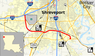
Louisiana Highway 3132 (LA 3132) is a state highway located in Shreveport, Louisiana. It runs 10.25 miles (16.50 km) in a general east–west direction from the junction of Interstates 20 and 220 to LA 523, serving as a southwestern bypass of the downtown area. With I-220, the highway helps to carry through traffic between the two disconnected portions of Interstate 49 (I-49), the area's main north–south route.
Interstate 55 (I-55) is a part of the Interstate Highway System that spans 964.25 miles (1,551.81 km) from LaPlace, Louisiana to Chicago, Illinois. Within the state of Louisiana, the highway travels 66 miles (106 km) from the national southern terminus at I-10 in LaPlace to the Mississippi state line north of Kentwood.

U.S. Highway 51 (US 51) is a part of the United States Numbered Highway System that spans 1,277 miles (2,055 km) from LaPlace, Louisiana to a point north of Hurley, Wisconsin. Within the state of Louisiana, the highway travels 69.12 miles (111.24 km) from the national southern terminus at US 61 in LaPlace to the Mississippi state line north of Kentwood.
The National Weather Service Weather Forecast Office New Orleans/Baton Rouge, Louisiana is a National Weather Service office located in Slidell, Louisiana.


