U.S. Route 66 or U.S. Highway 66, also known as the Will Rogers Highway, the Main Street of America or the Mother Road, was one of the original highways in the U.S. Highway System. US 66 was established on November 11, 1926, with road signs erected the following year. The highway, which became one of the most famous roads in the United States, originally ran from Chicago, Illinois, through Missouri, Kansas, Oklahoma, Texas, New Mexico, and Arizona before ending in Santa Monica in Los Angeles County, California, covering a total of 2,448 miles (3,940 km). It was recognized in popular culture by both the hit song "(Get Your Kicks on) Route 66" and the Route 66 television series, which aired on CBS from 1960 to 1964. In John Steinbeck's classic American novel, The Grapes of Wrath (1939), the road "Highway 66" symbolized escape and loss.
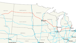
Interstate 94 (I-94) is an east–west Interstate Highway connecting the Great Lakes and northern Great Plains regions of the United States. Its western terminus is in Billings, Montana, at a junction with I-90; its eastern terminus is in Port Huron, Michigan, where it meets with I-69 and crosses the Blue Water Bridge into Sarnia, Ontario, Canada, where the route becomes Ontario Highway 402. It thus lies along the primary overland route from Seattle to Toronto, and is the only east–west Interstate highway to form a direct connection into Canada. I-94 intersects with I-90 several times: at its western terminus; Tomah to Madison in Wisconsin; in Chicago, and in Lake Station, Indiana. All together the major cities that I-94 connects to are Billings; Fargo, North Dakota; Minneapolis–Saint Paul; Madison; Milwaukee; Chicago; and Detroit.
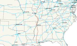
Interstate 55 (I-55) is a major Interstate Highway in the central United States. As with most interstates that end in a five, it is a major cross-country, north-south route, connecting the Gulf of Mexico to the Great Lakes. The highway travels from LaPlace, Louisiana, at I-10 to Chicago at U.S. Route 41, at McCormick Place. The major cities that I-55 connects to are New Orleans, Jackson, Mississippi, Memphis, St. Louis, and Chicago.
Interstate 57 (I-57) is an Interstate Highway in Missouri and Illinois that parallels the old Illinois Central rail line for much of its route. It runs from Sikeston, Missouri, at Interstate 55 to Chicago, Illinois, at Interstate 94. I-57 essentially serves as a shortcut route for travelers headed between the south and Chicago, bypassing St. Louis, Missouri. Between the junction of I-55 and I-57 in Sikeston, Missouri and the junction of I-55 and I-90/94 in Chicago, I-55 travels for 436 miles (702 km), while the combination of I-57 and I-94 is only 396 miles (637 km) long between the same two points. In fact, both the control cities on the overhead signs, as well as destination mileage signs, reference Memphis, Tennessee along southbound I-57, even as far north as its northern origin at I-94 in Chicago. Likewise, at its southern end, Chicago is the control city listed for I-57 on signs on northbound I-55 south of Sikeston, Missouri, even though I-55 also goes to Chicago.

U.S. Route 12 is an east–west United States highway, running from Aberdeen, Washington, to Detroit, Michigan, for almost 2,500 miles (4,000 km). The highway has mostly been superseded by Interstate 90 (I-90) and I-94, but remains an important link for local and regional destinations.
Interstate 294 (I-294) is a tolled auxiliary Interstate Highway in northeastern Illinois. It forms the southern portion of the Tri-State Tollway in Illinois. I-294 runs from South Holland at I-80/I-94, and Illinois Route 394 (IL 394) to Northbrook at I-94. I-294 is 53.42 miles (85.97 km) long; 5.32 miles (8.56 km) are shared with I-80. It serves as a bypass around the city of Chicago. I-294 is also the longest auxiliary route of I-94, at 10 miles (16 km) longer than I-494 in Minneapolis–Saint Paul. In addition the tollway is the longest auxiliary Interstate Highway in Illinois.
The Peoria-to-Chicago Highway refers to an effort made in the U.S. state of Illinois in the late 1990s to directly connect the cities of Peoria and Chicago with a multilane freeway. Plans for any highway failed due to grass-roots efforts against the highway.
Interstate 255 (I-255) is a bypass route of I-55 in Greater St. Louis. Along with I-270, it forms a loop around the central portion of the bi-state metro area; a majority of I-255 is located on the Illinois half. It shares its southern terminus with I-270 at the junction with I-55; I-270 goes to the west, and I-255 goes to the east. U.S. Route 50 joins I-255 at Lemay Ferry Road. It crosses the Mississippi River on the Jefferson Barracks Bridge, enters Illinois, and then turns northeast. There is a junction with I-64, where US 50 breaks off and goes east, and then further north there is a junction with I-55 again, I-70, and US 40, all of which are all co-signed together. The next junction is another one with I-270, which is the northern terminus of I-255. After that, the limited-access freeway continues on as Illinois Route 255 (IL 255). I-255 is 30.82 miles (49.60 km) in length.
Interstate 41 (I-41) is a 176.33-mile-long (283.78 km) north–south Interstate Highway connecting the interchange of I-94 and U.S. Route 41, located 0.9 miles (1.4 km) south of the Wisconsin–Illinois border at the end of the Tri-State Tollway in metropolitan Chicago, to an interchange with I-43 in metropolitan Green Bay, Wisconsin. The designation travels concurrently with US 41, I-894, US 45, I-43, and sections of I-94 in Wisconsin and Illinois. The route was officially added to the Interstate Highway System on April 7, 2015, and connects Milwaukee and Green Bay with the Fox Cities.

Forgottonia, also spelled Forgotonia, is the name given to a 16-county region in Western Illinois in the late 1960s and early 1970s. This geographic region forms the distinctive western bulge of Illinois that is roughly equivalent to "The Tract", the Illinois portion of the Military Tract of 1812, along and west of the Fourth Principal Meridian. Since this wedge-shaped region lies between the Illinois and Mississippi rivers, it has historically been isolated from the eastern portion of Central Illinois.
The Crosstown Expressway, was a proposed highway route in Chicago, Illinois. It was originally proposed through the 1960s and 1970s.
U.S. Route 20 in the U.S. state of Illinois is a major arterial highway that runs from the Iowa state line at East Dubuque at the northwestern tip of Illinois, to the Indiana state line at Chicago south of the Chicago Skyway, a distance of 233.93 miles (376.47 km). For its entire length, US 20 is designated as the General Ulysses S. Grant Highway, often abbreviated the U.S. Grant Memorial Highway. However, this name is only commonly used west of Elgin. US 20 bypasses the city of Elgin on a freeway known as the Elgin Bypass or Dr. Martin Luther King Jr. Memorial Highway. From Elgin to Melrose Park, US 20 follows Lake Street. It then follows Mannheim Road, and further south La Grange Road. US 20 also follows 95th Street as it turns east through Chicago's southwestern suburbs. It ultimately leaves Illinois on Indianapolis Boulevard.
U.S. Route 30 (US 30) is an east–west arterial surface road in northern Illinois. It runs from across the Mississippi River from Clinton, Iowa, to Lynwood at the Indiana state line. This is a distance of 153.79 miles (247.50 km).
Crosstown Expressway may refer to:
Interstate 80 (I-80) is a part of the Interstate Highway System that runs from San Francisco, California, to Teaneck, New Jersey. I-80 enters Illinois from Iowa in the west, southwest of Rapids City and runs generally eastward through East Moline, LaSalle and Joliet, before entering Indiana in Lansing. The interstate runs for approximately 163.41 miles (262.98 km) through the state.
Interstate 94 (I-94) generally runs north–south through the northeastern portion of the U.S. state of Illinois, in Lake and Cook counties. It is marked east–west in Illinois in accordance with its general alignment across the country. I-94 in Illinois is 78.00 miles (125.53 km) long.
Interstate 90 (I-90) in the U.S. state of Illinois runs roughly northwest-to-southeast through the northern part of the state. From the Wisconsin state line at South Beloit, it heads south to Rockford before heading east-southeast to the Indiana state line at Chicago. I-90 traverses 108 miles (174 km) through a variety of settings, from farmland west of the Fox River Valley through the medium-density suburbs west of O'Hare International Airport, through downtown Chicago, and through the heart of the industrial southeast side of Chicago before entering Indiana.
Interstate 55 (I-55) is a major north–south Interstate Highway in the U.S. state of Illinois that connects the St. Louis, Missouri, and Chicago metropolitan areas. It enters the state from Missouri on the Poplar Street Bridge near East St. Louis and runs to U.S. Route 41 near downtown Chicago where the highway ends, a distance of 294.38 miles (473.76 km). The Road also runs through the cities of Springfield, Bloomington, and Joliet. The section in DuPage County is officially named Joliet Freeway or Will Rogers Freeway and in Cook County is officially named the Stevenson Expressway.
Ogden Avenue is a street extending from the Near West Side of Chicago to Naperville, Illinois. It was named for William B. Ogden, the first mayor of Chicago.
The Chicago–Kansas City Expressway is a highway that runs between Chicago, Illinois, and Claycomo, Missouri. The road is known as Route 110 in Missouri and Illinois Route 110 (IL 110) in Illinois. IL 110 was created through legislation on May 27, 2010, as the designated route for the Illinois portion of the Chicago–Kansas City Expressway.