
Isla Espíritu Santo is an uninhabited island in the Gulf of California, off the Mexican state of Baja California Sur. It is separated from Isla Partida by a narrow canal.
Isla Natividad is an island in the Pacific Ocean 6 km west off Punta Eugenia, the northwestern headland of the Mexican state of Baja California Sur. 200 meters off its northwestern end lies Roca María at 27°53′33″N115°13′19″W, with an area of 0.074 km2. Isla Natividad is separated from the mainland at Punta Eugenia by Canal de Dewey, and from Cedros Island, which is 15 km to the north, by Canal de Keller.
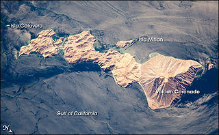
Isla Coronado, occasionally referred to as “Smith Island”, is just off the eastern shoreline of Mexico's Baja California Peninsula near Bahía de los Ángeles in the Gulf of California. The island is approximately 7 kilometers long and it is dominated by a volcano on its northern end. It is part of the Ensenada Municipality.
Isla Mitlán, is an island in the Gulf of California, located within Bahía de los Ángeles east of the Baja California Peninsula. It is adjacent to the west coast of Isla Coronado.The island is uninhabited and is part of the Ensenada Municipality.
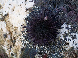
The sea urchins of the Gulf of California live between the coasts of the Baja California Peninsula to the west and mainland state of Sonora, Mexico to the east. The northern boundary is the lateral band of land with the remains of the Colorado River Delta, and the southern is the Pacific Ocean.
Isla Ballena, is an island in the Gulf of California east of the Baja California Peninsula. The island is uninhabited and is part of the La Paz Municipality.

Isla Las Animas, is an island in the Gulf of California east of the Baja California Peninsula. The island is uninhabited and is part of the La Paz Municipality.
Isla Monserrate, is an island in the Gulf of California east of the Baja California Peninsula. The island is uninhabited and is part of the Loreto Municipality.
Isla Pardo, is an island in the Gulf of California east of the Baja California Peninsula. The island is uninhabited and is part of the Loreto Municipality.
Isla San Francisco is a small island in Mexico located in the Gulf of California off the eastern coast of Baja California Sur, south of Isla San José. Uninhabited, the island is located in the southern portion of the Gulf of California, north of the Bay of La Paz, some 75 km (47 mi) north of the town of La Paz and is part of the La Paz Municipality. It is separated from the peninsula of Baja California by a channel about 10 km (6.2 mi) wide. The island is 2.5 km (1.6 mi) long and 2.5 km (1.6 mi) wide with maximum total area of 3.78 km2.
Isla Santa Catalina, officially known as Isla Catalana, is an island in the Gulf of California east of the Baja California Peninsula. The island is uninhabited and is part of the Loreto Municipality.
Isla Santa Cruz, is an island in the Gulf of California, east of the Baja California Peninsula in Baja California Sur state.
Isla Santiago, is an island in the Gulf of California, east of the Baja California Peninsula in Baja California Sur state.
Isla Rasa is an island in the Gulf of California east of the Baja California Peninsula. The island is uninhabited and is part of the Mexicali Municipality. The 0.21 sq./mi island has three small ponds and has small shed located in the center of the island.
Isla Salsipuedes is an island in the Gulf of California off the coast of the Baja California Peninsula. The island is uninhabited and is part of the Mexicali Municipality.
Isla San Lorenzo Norte is an island in the Gulf of California east of the Baja California Peninsula. The island is uninhabited and is part of the Mexicali Municipality. The much larger Isla San Lorenzo Sur is located immediately southeast of Isla San Lorenzo Norte.
Isla San Lorenzo Sur, is an island in the Gulf of California east of the Baja California Peninsula. The island is uninhabited and is part of the Mexicali Municipality. Isla San Lorenzo Norte is located immediately northwest of Isla San Lorenzo Sur.
Isla San Luis is an island in the Gulf of California east of the Baja California Peninsula. The island is uninhabited and is part of the San Felipe Municipality.
Isla San Martín is an island in the Pacific Ocean west of the Baja California Peninsula. The island is uninhabited and is part of the Ensenada Municipality.

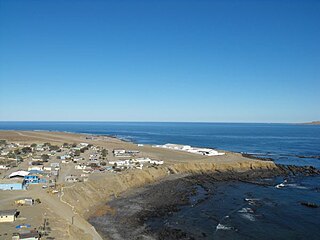
San Felipe is the newest municipality in the Mexican state of Baja California. Inaugurated on 1 January 2022, it is located approximately 190 kilometres (120 mi) south of Mexicali, the state capital.
