
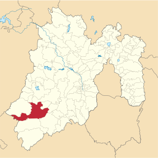
Querétaro, officially the Free and Sovereign State of Querétaro, is one of the 32 federal entities of Mexico. It is divided into 18 municipalities. Its capital city is Santiago de Querétaro. It is located in north-central Mexico, in a region known as Bajío. It is bordered by the states of San Luis Potosí to the north, Guanajuato to the west, Hidalgo to the east, México to the southeast and Michoacán to the southwest.
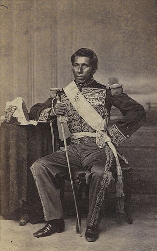
José Tomás de la Luz Mejía Camacho, better known as Tomás Mejía, was a Mexican soldier of Otomi background, who consistently sided with the Conservative Party throughout its nineteenth century conflicts with the Liberals.

Pinal de Amoles is a town located in Pinal de Amoles Municipality in the state of Querétaro in central Mexico. It is part of the Sierra Gorda region which stretches over northern Querétaro into Guanajuato, Hidalgo and San Luis Potosí, with 88% of the municipality's land comprising the Sierra Gorda Biosphere Reserve. The municipality contains large areas of forests and the highest peaks in the region, which separate the wetter areas of both the north and east from the drier areas of the south and west. The town began as a mining camp in the 17th century. However, most mining in the area has disappeared and the municipality is one of the poorest in Mexico, despite recent efforts to promote ecotourism and restart mining. This has led a large number of residents to migrate to larger cities in Mexico and to the United States to work, sending remittances back home. These remittances now overshadow the locally generated economy.

The Franciscan missions of the Sierra Gorda of Querétaro in Mexico, are five missions built between 1750 and 1760, the foundation of the missions is attributed to Junípero Serra, who also founded the most important missions in California. They were declared a World Heritage Site by UNESCO in 2003.
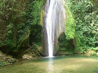
The Sierra Gorda is an ecological region centered on the northern third of the Mexican state of Querétaro and extending into the neighboring states of Guanajuato, Hidalgo and San Luis Potosí. Within Querétaro, the ecosystem extends from the center of the state starting in parts of San Joaquín and Cadereyta de Montes municipalities and covering all of the municipalities of Peñamiller, Pinal de Amoles, Jalpan de Serra, Landa de Matamoros and Arroyo Seco, for a total of 250 km2 of territory. The area is extremely rugged with high steep mountains and deep canyons. As part of the Huasteca Karst, it also contains many formations due to erosion of limestone, especially pit caves known locally as sótanos. The area is valued for its very wide diversity of plant and animal life, which is due to the various microenvironments created by the ruggedness of the terrain and wide variation in rainfall. This is due to the mountains’ blocking of moisture coming in from the Gulf of Mexico, which generally makes the east side fairly moist and the west semiarid scrub brush. Most of the region has been protected in two biosphere reserves, with the one centered in Querétaro established in 1997 and the one centered in Guanajuato established in 2007. The Sierra Gorda is considered to be the far west of the La Huasteca region culturally and it is home to the Franciscan Missions in the Sierra Gorda World Heritage Site.

Jalpan de Serra is a city in Jalpan de Serra Municipality located in the north of the Mexican state of Querétaro. It is located in the heart of an important ecological zone called the Sierra Gorda. It is also the site two of five Franciscan missions, including the first one, to have been built in the mid-18th century, and declared a World Heritage Site in 2003. The municipality is also home to a small but important indigenous group called the Pame. However, the municipality has been losing population since the mid-20th century even though recent events such as the town being named a Pueblo Mágico have worked to create a tourism industry.
Tejupilco is a municipality in the State of Mexico, Mexico, located approximately 100 kilometres (62 mi) southwest of the state capital Toluca, along Federal Highway 134. Its municipal seat is Tejupilco de Hidalgo. The municipality has a total area of about 1,327 km2 (512 sq mi), with a contrasting topography ranging from deep ravines and canyons to high ridges; the highest elevation within the municipality reaches some 1,117 metres (3,660 ft) asl. The 2005 census recorded a population of 62,547 inhabitants.
The following radio stations broadcast on AM frequency 850 kHz: 850 AM is a United States clear-channel frequency. KOA and KICY share Class A status of 850 kHz.
The following radio stations broadcast on AM frequency 1200 kHz: 1200 AM is classified by the Federal Communications Commission as a United States clear-channel frequency. WOAI San Antonio is the dominant Class A station.
Federal Highway 69 (Fed. 69) is a free (libre) part of the federal highways corridors of Mexico. The highway connects Fed. 70 in Rioverde, San Luis Potosí to Fed. 120 in Jalpan de Serra, Querétaro.
San Raymundo Jalpan is a town and municipality in Oaxaca in south-western Mexico. The municipality covers an area of km². It is part of the Centro District in the Valles Centrales region.

Jalpan is a town and municipality in Puebla in south-eastern Mexico.

Centro District is located in the Valles Centrales Region of the State of Oaxaca, Mexico. The district includes the state capital Oaxaca and satellite towns. The district has an average elevation of 1,550 meters. The climate is mild, with average temperatures ranging from 16°C in Winter to 25°C in spring.
Abelardo Ávila Villareal (1907-1967) was a Mexican engraver noted for his Costumbrista work, mostly with the Sociedad Mexicana de Grabadores; however, he did paint one mural along with Pedro Rendón at the Abelardo L. Rodríguez market in Mexico City.
Zaachila Zapotec is a small Zapotec language of Oaxaca, Mexico. It is perhaps a dialect of Yatzeche Zapotec, which is 85% intelligible to Zaachila speakers. Tilquiapan Zapotec is 75% intelligible, 72% of San Juan Guelavía to Zaachila speakers.
Radio y Televisión Querétaro (RTQ) is the state radio and television network of the Mexican state of Querétaro, broadcasting on two radio stations and one television station in the state. It is operated by the Sistema Estatal de Comunicación Cultural y Educativa del Gobierno de Querétaro (SECCE), or "State System for Cultural and Educational Communication of the Government of Querétaro".
XHJAQ-FM is a radio station on 107.1 FM in Jalpan de Serra, Querétaro, Mexico. The station is owned by Grupo Edikam and carries a grupera format known as La Ke Buena. The transmitter is located atop Cerro la Colgada in Jalpan de Serra.
The 2006–07 Segunda División de México season was split in two tournaments Apertura and Clausura. Segunda División was the third-tier football league of Mexico. The season was played between 26 August 2006 and 26 May 2007.
Hemirrhagus akheronteus is a tarantula which is part of the Hemirrhagus genus. It is found in Mexico, in the state of Queretaro, and is one of many Mexican cave tarantulas. It was first described by Mendoza and Francke in 2018. It is named after the latin word akheronteus, which means "pertaining to the stream of woe", referring to the acheron river in the infernal regions of Greek mythology.