
Jane Jacobs was an American-Canadian journalist, author, theorist, and activist who influenced urban studies, sociology, and economics. Her book The Death and Life of Great American Cities (1961) argued that "urban renewal" and "slum clearance" did not respect the needs of city-dwellers.

Baby Point is a residential neighbourhood in Toronto, Ontario, Canada. It is bounded on the west by the Humber River from south of Baby Point Crescent to St. Marks Road, east to Jane Street and Jane Street south to Raymond Avenue and Raymond Avenue west to the Humber. It is within the city-defined neighbourhood of 'Lambton-Baby Point'. Baby Point is within the proximity of Jane station.

Humber River—Black Creek is a federal electoral district in Toronto, Ontario, Canada, that has been represented in the House of Commons of Canada from 1867 to 1904 and since 1917. Prior to the 2015 election, the riding was known as York West. The former name reflects the riding is in the former Township of York which is within the City of Toronto.
Weston is a neighbourhood and former town in Toronto, Ontario, Canada. The neighbourhood is situated in the northwest of the city, south of Highway 401, east of the Humber River, north of Eglinton Avenue, and west of Jane Street. The eponymous Weston Road, just north of Lawrence Avenue is the historic core of Weston, with many small businesses and services. Weston was incorporated as a village in the 19th century and was absorbed into the Borough of York in the late 1960s. York itself was amalgamated into Toronto in 1998. Weston is one of the few former towns and villages in Toronto located in a generally suburban setting, although it is contiguous with the inner city to the southeast along Weston Road. It is also one of the few not developed as a planned satellite town, as is the case with Leaside or New Toronto.

St. Clair Avenue is a major east-west street in Toronto, Ontario, Canada. It was laid out in the late 18th century by the British as a concession road, 2 kilometres (1.2 mi) north of Bloor Street and 4 kilometres (2.5 mi) north of Queen Street.

Jane and Finch is a neighbourhood located in the northwest end of Toronto, Ontario, Canada, in the district of North York. Centred at the intersection of Jane Street and Finch Avenue West, the area is roughly bounded by Highway 400 to the west, Black Creek to the east, Sheppard Avenue to the south, and Steeles Avenue to the north.

Finch Avenue is an arterial thoroughfare that travels east–west in Toronto, Ontario, Canada. The road continues west into the Regional Municipality of Peel as Regional Road 2 and east into the Regional Municipality of Durham as Regional Road 37.

Jane is a subway station on Line 2 Bloor–Danforth of the Toronto subway in Toronto, Ontario, Canada. It is located just north of Bloor Street West, spanning the block east of Jane Street to Armadale Avenue, with entrances from all three streets. It opened in 1968 as part of the westerly extension from Keele to Islington Station. Wi-Fi service is available at this station.
Black Creek Drive is a four lane north–south arterial road in Toronto, Ontario, Canada. It connects Weston Road and Humber Boulevard with Highway 401 via Highway 400, the latter of which it forms a southerly extension. Black Creek Drive officially transitions into Highway 400 at the Maple Leaf Drive overpass, southeast of Jane Street. The roadway is named after the Black Creek ravine, which it parallels for most of its route. It features a maximum speed limit of 70 km/h (43 mph). As a municipal road, it is patrolled by the Toronto Police Service.
Amesbury or Brookhaven-Amesbury is a neighbourhood in Toronto, Ontario, Canada. The neighbourhood is located in northern Toronto in the former suburb of North York. It is part of federal and provincial electoral district York South—Weston, and Toronto electoral wards 11: York South—Weston (West) and 12: York South—Weston (East).

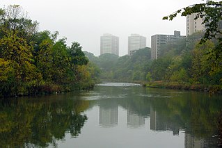
Old Mill is a neighbourhood of Toronto, Ontario, Canada on the banks of the Humber River. It is located north and west of the intersection of Bloor Street and Jane Street. The area takes its name from the old grist mill ruins on the west bank of the river, now converted into a hotel. The City of Toronto includes this neighbourhood in the official "Lambton Baby Point" neighbourhood which includes the Baby Point enclave and former Lambton village areas to the north.

Rockcliffe–Smythe is a neighbourhood in Toronto, Ontario, Canada. It was developed after World War II as part of the urbanization of the former suburb of York Township. It is in Ward 5 in the City of Toronto.

Lambton is a neighbourhood in the city of Toronto, Ontario, Canada. It is situated on the east bank of the Humber River north and south of Dundas Street West. It is bounded on the north by Black Creek, on the east by Jane Street and on the south by St. Mark's Road. The area west of Gooch Avenue and south of Dundas Street West is also known as "Warren Park", the name of the housing sub-division built in the 1950s. The portion south of Dundas Street West is within the 'Lambton Baby Point' neighbourhood as defined by the City of Toronto.
The Jane LRT is an inactive proposal for a light rail line in Toronto, Ontario, Canada. It was originally proposed in 2007, cancelled in 2010, and later revived in the 2013 "Feeling Congested?" report by the City of Toronto, where it was labelled as a "Future Transit Project". However, in April 2019, Ontario Premier Doug Ford announced the province's plans for rapid transit development and funding for the Greater Toronto Area that omitted the Jane LRT.

Line 6 Finch West, also known as the Finch West LRT, is a light rail line under construction in Toronto, Ontario, Canada, to be operated by the Toronto Transit Commission. The 10.3-kilometre (6.4 mi), 18-stop line is to extend from Finch West station on Line 1 Yonge–University to the North Campus of Humber College in Etobicoke. The line will operate in a dedicated above-ground right-of-way, much of it within Finch Avenue, segregated from street traffic. The line will use transit signal priority and standard gauge rather than the broad Toronto gauge. The line is forecast to carry about 14.6 million rides a year or 40,000 a day by 2031 and will replace the 36 Finch West bus route, which is one of the three busiest bus routes in Toronto. The line is expected to open within the first half of 2024, with an estimated cost of CA$2.5 billion.

Runnymede is a neighbourhood in Toronto, Ontario, Canada located north of Bloor Street West between Jane Street and Runnymede Road north to Dundas Street West. It is located directly north of the former village of Swansea and west of the High Park North neighbourhood. The immediate area around Bloor Street is commonly known as Bloor West Village after the shopping area along Bloor Street, whereas the area to the north is considered the Runnymede neighbourhood.

Graffiti in Toronto, Ontario, Canada, is a cause of much disagreement among its residents. Graffiti is seen by some as an art form adding to the Toronto culture; however, others see graffiti as form of vandalism, viewing it as ugly, or as a form of property damage.

Humber Cinemas, originally the Odeon Humber Theatre, was a movie theatre in Toronto, Ontario, Canada. The theatre was operated by the Odeon and Loews Cineplex chains until 2003. The theatre re-opened as an independent theatre in 2011 and operated until 2019 when it closed permanently. The theatre was located on Bloor Street just west of Jane Street.