
Civic Center/Grand Park station is an underground rapid transit station on the B Line and D Line of the Los Angeles Metro Rail system. The station also has street level stops for the J Line of the Los Angeles Metro Busway system. The station is located under Hill Street at its intersection with 1st Street. It is located in the Civic Center neighborhood of Los Angeles, after which the station is named, alongside the nearby Grand Park.

Pershing Square station is an underground rapid transit station on the B Line and D Line of the Los Angeles Metro Rail system. The station also has street-level stops for the J Line of the Los Angeles Metro Busway system. The station is located under Hill Street between 4th and 5th Street. It is located in Downtown Los Angeles with one station entrance across the street from Pershing Square, after which the station is named, and the other is located near the historic Angels Flight funicular which provides access to the high-rise office buildings in the Bunker Hill neighborhood.

7th Street/Metro Center station is an underground light rail and rapid transit station on the A, B, D, and E lines of the Los Angeles Metro Rail system. The station also has street level stops for the J Line of the Los Angeles Metro Busway system. The station is located under 7th Street, after which the station is named, at its intersections with Figueroa, Flower and Hope Streets.

Pico station is an at-grade light rail station on the Los Angeles Metro Rail system located on Flower Street at the intersection of Pico Boulevard. The station also has southbound bus stops on Flower Street, across from the station and northbound bus stops on Figueroa Street, one block to the west. Pico station serves the South Park and Figueroa/Convention District neighborhoods.

Grand/LATTC station is an at-grade light rail station on the A Line of the Los Angeles Metro Rail system. The station is located in the median of Washington Boulevard at its intersection with Grand Avenue, after which the station is named, along with Los Angeles Trade–Technical College (LATTC). One of the station's exits leads directly to the LATTC campus. The station also has nearby stops for the J Line of the Los Angeles Metro Busway system, southbound buses stop at the intersection of Flower Street and Washington Boulevard, one block to the west of the station, and northbound buses stop at the intersection of Figueroa Street and Washington Boulevard, two blocks to the west. In addition to the LATTC campus, the station also serves the South Los Angeles neighborhood.

1st Street station is an at-grade light rail station on the A Line of the Los Angeles Metro Rail system. The station is located in the median of Long Beach Boulevard at its intersection with 1st Street, after which the station is named, in Long Beach, California. The station is on a loop at the south end of the A Line route and only has southbound service.

Downtown Long Beach station is an at-grade light rail station on the A Line of the Los Angeles Metro Rail system. The station is located in the middle of 1st Street between Pine Avenue and Pacific Avenue in Downtown Long Beach, California, after which the station is named. It is the southern terminus of the A Line.

103rd Street/Watts Towers station is an at-grade light rail station on the A Line of the Los Angeles Metro Rail system. The station is located alongside the Union Pacific freight railroad's Wilmington Subdivision, at its intersection with 103rd Street, after which the station is named, along with the nearby landmark Watts Towers in the Watts neighborhood of Los Angeles, California.
Vernon station is an at-grade light rail station on the A Line of the Los Angeles Metro Rail system. The station is located in the center median of Long Beach Avenue at its intersection with Vernon Avenue, in South Los Angeles, one-quarter mile (0.4 km) from the border with Vernon, California.

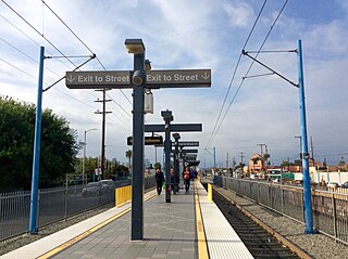
37th Street/USC station is a busway station located in Los Angeles, California. It is situated between the LATTC/Ortho Institute and Slauson stations on the J Line, a bus rapid transit route which runs between El Monte, Downtown Los Angeles and San Pedro as part of the Metro Busway system. The station consists of two side platforms in the center of Interstate 110 above 37th Street, adjacent to the University of Southern California campus. The station serves the University Park, Exposition Park and Historic South Central neighborhoods of Los Angeles.

Memorial Park station is a below-grade light rail station on the A Line of the Los Angeles Metro Rail system. It is located at Holly Street and at the end of Arroyo Parkway in Pasadena, California. The station is named after the nearby Memorial Park and is situated on the northern edge of Old Town Pasadena.

Mariachi Plaza station is an underground light rail station on the E Line of the Los Angeles Metro Rail system. It is located under 1st Street at the intersection of Boyle Avenue, with the main exit located at Mariachi Plaza, after which the station is named. The plaza is the historic gateway to the Boyle Heights neighborhood of Los Angeles. This station opened in 2009 as part of the Gold Line Eastside Extension and was one of two underground stations on the Eastside Extension.

Expo Park/USC station is an at-grade light rail station on the E Line of the Los Angeles Metro Rail system. The station is located in the center median of Exposition Boulevard near entrances to Exposition Park and the University of Southern California (USC), after which the station is named. The 37th Street/USC station for the J Line of the Los Angeles Metro Busway system is located a few blocks east of the station.

LATTC/Ortho Institute station, officially Los Angeles Trade–Technical College/Orthopaedic Institute for Children station, is an at-grade light rail station on the E Line of the Los Angeles Metro Rail system. The station is located alongside Flower Street between 23rd Street and Adams Boulevard. The station is located near the Los Angeles Trade–Technical College (LATTC) and the Orthopaedic Institute for Children, after which the station is named. In addition to the LATTC campus and the Ortho Institute, the station also serves the North University Park neighborhood. The station also has nearby stops for the J Line of the Los Angeles Metro Busway system, southbound buses stop on Flower Street, across from the station at both 23rd Street and Adams Boulevard and northbound buses stop on Figueroa Street, one block to the west.

Expo/Vermont station is an at-grade light rail station on the E Line of the Los Angeles Metro Rail system. The station is located in the center median of Exposition Boulevard at its intersection with Vermont Avenue, after which the station is named, near the Exposition Park and West Adams neighborhoods of Los Angeles.

Expo/Western station is an at-grade light rail station on the E Line of the Los Angeles Metro Rail system. The station is located in the center median of Exposition Boulevard at its intersection with Western Avenue, after which the station is named, in the West Adams neighborhood of Los Angeles.

Expo/Crenshaw station is a light rail station in the Los Angeles Metro Rail system located in the Jefferson Park neighborhood of Los Angeles at the intersection of Crenshaw and Exposition Boulevards. During construction, it was known as the Crenshaw station. The station is the transfer point between the E Line, which stops at two street-level platforms alongside Exposition Boulevard, and the K Line, which has its northern terminus at a single island platform under Crenshaw Boulevard.

Farmdale station is an at-grade light rail station on the E Line of the Los Angeles Metro Rail system. The station is located in the center median of Exposition Boulevard at its intersection with Farmdale Avenue, after which the station is named, in the West Adams neighborhood of Los Angeles. It is located between Expo/La Brea station to the west and Expo/Crenshaw station to the east.
Downtown Santa Monica station is an at-grade light rail station in the Los Angeles Metro Rail system. It is located near the intersection of 4th Street and Colorado Avenue in downtown Santa Monica, California. It is the E Line's western terminal station.

Grand Avenue Arts/Bunker Hill station is an underground light rail station on the A and E lines of the Los Angeles Metro Rail system. The station also has street level stops for the J Line of the Los Angeles Metro Busway system. The station is located under the intersection of 2nd Place and Hope Street, near the Grand Avenue Arts district and in the Bunker Hill neighborhood of Downtown Los Angeles, after which the station is named. In planning documents, the station was originally referred to as 2nd Place/Hope.


