Bolgatanga, colloquially known as Bolga, is a town and the capital of the Bolgatanga Municipal District and Upper East Region of Ghana, adjacent to the border with Burkina Faso. Bolgatanga has over 2012 settlement and a population of about 66,685 people. Bolgatanga is 161 km to the north of Tamale. Bolgatanga lies in the Red Volta River Valley, with the White Volta River and the cliffs of the Gambaga Escarpment to the south of the town forming the southern boundary of the Upper East Region.
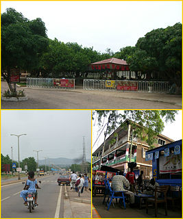
Wa is a town and the capital of Wa Municipal District and the Upper West Region of northern Ghana. Wa had a 2012 settlement population of 102,446. Features of the town include several churches and mosques, the Wa-Na Palace, the St. Andrew's Catholic cathedral, the University for Development Studies (UDS), a museum, a nearby hippopotamus sanctuary in Wicheau, the mushroom rock In Jirapa and the ants hill at Nanvielle. The geography of Wa is notable for the dramatic monadnock Ombo Mountain, which is located around Kaleo and visible from much of the Wa town. Other notable towns around Wa region include Naaha and Ga.

The Upper West Region of Ghana is located in the north-western corner of Ghana and is bordered by Upper East region to the east, Northern region to the south, and Burkina Faso to the west and north. The Upper West regional capital and largest settlement is Wa. The Upper West was created by the then Head of State, Flight-Lieutenant Jerry Rawlings in 1983 under the Provisional National Defense Council (PNDC) military regime. The area was carved out of the former Upper Region, which is now the Upper East Region. For about thirty-five years, it remained the youngest region of Ghana until 2018 when six more regions were created by the Nana Addo Dankwa Akufo-Addo government; hence increasing the total number of administrative regions in the country to sixteen.

The Ashanti Region is located in south Ghana and it is the third largest of 16 administrative regions, occupying a total land surface of 24,389 km2 (9,417 sq mi) or 10.2 percent of the total land area of Ghana. In terms of population, however, it is the most populated region with a population of 4,780,380 according to the 2011 census, accounting for 19.4% of Ghana's total population. The Ashanti Region is known for its major gold bar and cocoa production. The largest city and regional capital is Kumasi.
The Upper East Region is located in north Ghana and is the third smallest of the 16 administrative regions in Ghana. It occupies a total land surface of 8,842 square kilometers or 2.7 per cent of the total land area of Ghana. The Upper East regional capital is Bolgatanga, sometimes referred to as Bolga. Other major towns in the region include Navrongo, Paga, Bawku and Zebilla.

The Eastern Region is located in south Ghana and is one of the sixteen administrative regions of Ghana. Eastern region is bordered to the east by the Lake Volta, to the north by Bono East Region and Ashanti region, to the west by Ashanti region, to the south by Central region and Greater Accra Region. Akans are the dominant inhabitants and natives of Eastern region and Akan, Ewe, Krobo, Hausa and English are the main spoken languages. The capital town of Eastern Region is Koforidua.The Eastern region is the location of the Akosombo dam and the economy of the Eastern region is dominated by its high-capacity electricity generation. Eastern region covers an area of 19,323 square kilometres, which is about 8.1% of Ghana's total landform.

Volta Region is one of Ghana's sixteen administrative regions, with Ho designated as its capital. It is located west of Republic of Togo and to the east of Lake Volta. Divided into 25 administrative districts, the region is multi-ethnic and multilingual, including groups such as the Ewe, the Guan, and the Akan peoples. The Guan peoples include the Lolobi, Likpe, Akpafu, Buem, and Nkonya people. This region was carved out of the Volta Region in December 2018 by the New Patriotic Party

Bongo District is one of the fifteen districts in Upper East Region, Ghana. Originally created as an ordinary district assembly in 1988; which was established by Legislative Instrument (L.I.) 1446. The municipality is located in the central part of Upper East Region and has Bongo as its capital town.

Lawra Municipal District is one of the eleven districts in Upper West Region, Ghana. Originally it was formerly part of the then-larger Lawra District in 1988; until the northern part of the district was later split off to create Nandom District on 28 June 2012; thus the remaining part has been remain as Lawra District, which it was later elevated to municipal district assembly status on 15 March 2018 to become Lawra Municipal District. The municipality is located in the northwest part of Upper West Region and has Lawra as its capital town.

Yilo Krobo Municipal District is one of the thirty-three districts in Eastern Region, Ghana. Originally created as an ordinary district assembly in 1988 when it was known as Yilo Krobo District, which it was created from the former Kaoga District Council, until it was elevated to municipal district assembly status on 6 February 2012 to become Yilo Krobo Municipal District. The municipality is located in the eastern part of Eastern Region and has Somanya as its capital town.
Bawku Municipal District is one of the fifteen districts in Upper East Region, Ghana. Originally created as an ordinary district assembly in 1988 when it was known as Bawku East District; which was established by Legislative Instrument (L.I.) 1439, until the southern part of the district was split off by a decree of president John Agyekum Kufuor in August 2004 to create Garu-Tempane District; thus the remaining part was elevated to municipal district assembly status on the same year to become Bawku Municipal District. However, on 28 June 2012, two parts of the district were later split off to create Binduri District and Pusiga District respectively; thus the remaining part has been retained as Bawku Municipal District. The municipality is located in the eastern part of Upper East Region and has Bawku as its capital town.
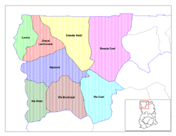
Wa Municipal District is one of the eleven districts in Upper West Region, Ghana. Originally created as an ordinary district assembly in 1988 when it was known as Wa District, until two parts of the district were later split off by a decree of president John Agyekum Kufuor in July 2004 to create Wa East District and Wa West District respectively; thus the remaining part was later elevated to municipal district assembly status on the same year to become Wa Municipal District. The municipality is located in the southern part of Upper West Region and has Wa as its capital town, which also serves as the regional capital of the Upper West Region.
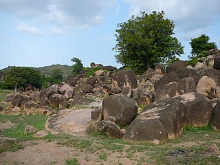
Jirapa is one of the constituencies represented in the Parliament of Ghana. It elects one Member of Parliament (MP) by the first past the post system of election. Jirapa is located in the Jirapa/Lambussie District of the Upper West Region of Ghana.

Sissala West is one of the constituencies represented in the Parliament of Ghana. It elects one Member of Parliament (MP) by the first past the post system of election. Sissala West is located in the Sissala West district of the Upper West Region of Ghana.
Lambussie is one of the constituencies represented in the Parliament of Ghana. It elects one Member of Parliament (MP) by the first past the post system of election. Lambussie is located in the Jirapa/Lambussie district of the Upper West Region of Ghana.
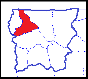
Lambussie Karni District is one of the eleven districts in Upper West Region, Ghana. Originally it was formerly part of the then-larger Jirapa/Lambussie District in 1988; until the northern part of the district was later split off to create Lambussie-Karni District on 29 February 2008; thus the remaining part has been renamed as Jirapa District. The district assembly is located in the northwest part of Upper West Region and has Lambussie as its capital town.

Kpandai District is one of the sixteen districts in Northern Region, Ghana. Originally it was formerly part of the then-larger East Gonja District in 1988, until the eastern part of the district was split off by a decree of president John Agyekum Kufuor on 29 February 2008 to create Kpandai District.; thus the remaining part has been retained as East Gonja Municipal District. The district assembly is located in the southern part of Northern Region and has Kpandai as its capital town.
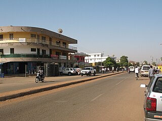
Lambussie is a small town and is the capital of Lambussie Karni district, a district in the Upper West Region of north Ghana.
The N12 or National Highway 12 is a national highway in Ghana that begins at the Ghana - Côte d'Ivoire border in the Western Region of Ghana and travels generally north to Hamile on the Ghana - Burkina Faso border. Its total length is 670 kilometres.
Jirapa Municipal District is one of the eleven districts in Upper West Region, Ghana. Originally it was formerly part of the then-larger Jirapa/Lambussie District in 1988; until the northern part of the district was later split off to create Lambussie-Karni District on 29 February 2008; thus the remaining part has been renamed as Jirapa District, which it was later elevated to municipal district assembly status on 15 March 2018 to become Jirapa Municipal District. The municipality is located in the northwest part of Upper West Region and has Jirapa as its capital town.