
Falmouth is a census-designated place (CDP) in Stafford County, Virginia, United States. Situated on the north bank of the Rappahannock River at the falls, the community is north of and opposite the city of Fredericksburg. Recognized by the U.S. Census Bureau as a census-designated place (CDP), Falmouth's population was 4,956 as of the 2020 census.

The Shenandoah Valley is a geographic valley and cultural region of western Virginia and the Eastern Panhandle of West Virginia in the United States. The Valley is bounded to the east by the Blue Ridge Mountains, to the west by the eastern front of the Ridge-and-Valley Appalachians, to the north by the Potomac River, to the south by the James River, and to the Southwest by the New River Valley. The cultural region covers a larger area that includes all of the Valley plus the Virginia Highlands to the west and the Roanoke Valley to the south. It is physiographically located within the Ridge and Valley Province and is a portion of the Great Appalachian Valley.

The Northern Neck is the northernmost of three peninsulas on the western shore of the Chesapeake Bay in the Commonwealth of Virginia. The Potomac River forms the northern boundary of the peninsula; the Rappahannock River demarcates it on the south. The land between these rivers was formed into Northumberland County in 1648, prior to the creation of Westmoreland County and Lancaster County.

The Allegheny Mountain Range, informally the Alleghenies, is part of the vast Appalachian Mountain Range of the Eastern United States and Canada and posed a significant barrier to land travel in less developed eras. The Allegheny Mountains have a northeast–southwest orientation, running for about 300 miles (480 km) from north-central Pennsylvania southward, through western Maryland and eastern West Virginia.

Northern Virginia, locally referred to as NOVA or NoVA, comprises several counties and independent cities in the Commonwealth of Virginia in the United States. The region radiates westward and southward from Washington, D.C., the nation's capital, and has a population of 3,257,133 people as of 2023 U.S. Census Bureau estimates, representing of a third of the state's total population. It is the most populous region in both Virginia and the regional Washington metropolitan area.

The Rappahannock River is a river in eastern Virginia, in the United States, approximately 195 miles (314 km) in length. It traverses the entire northern part of the state, from the Blue Ridge Mountains in the west where it rises, across the Piedmont to the Fall Line, and onward through the coastal plain to flow into the Chesapeake Bay, south of the Potomac River.
Peter Field Jefferson was a planter, cartographer and politician in colonial Virginia best known for being the father of the third president of the United States, Thomas Jefferson. The "Fry-Jefferson Map", created by Peter in collaboration with Joshua Fry in 1757, accurately charted the Allegheny Mountains for the first time and showed the route of "The Great Road from the Yadkin River through Virginia to Philadelphia distant 455 Miles"—what would later come to be known as the Great Wagon Road.

Thomas Fairfax, 6th Lord Fairfax of Cameron was a British peer, military officer and planter. The only member of the British peerage to reside in Britain's North American colonies, Fairfax owned the Northern Neck Proprietary in the Colony of Virginia, where he spent the majority of his life. The proprietary had been granted to Fairfax's ancestor John Colepeper, 1st Baron Colepeper by Charles II of England in 1649.
Major William Mayo was an English civil engineer who emigrated to the British colony of Virginia in 1723.

Fairfax Stone Historical Monument State Park is a West Virginia state park commemorating the Fairfax Stone, a surveyor's marker and boundary stone at the source of the North Branch of the Potomac River. The original stone was placed on October 23, 1746 to settle a boundary dispute between Thomas Fairfax, 6th Lord Fairfax of Cameron and the Privy Council of Great Britain concerning the Northern Neck of Virginia. It determined the proprietorship and boundaries of a large tract of mostly unsurveyed land in the British colonies of Maryland and Virginia.
George William Fairfax was a planter in colonial Virginia who represented then-vast Frederick County and later Fairfax County in the House of Burgesses before the American Revolutionary War, by which time he had returned to England. A mentor and good friend of George Washington, Fairfax made opportunities for the younger Washington through his powerful British family, and Washington assisted him afterward by arranging for the sale of his Virginia property after he returned to Britain.
Colonel Joshua Fry (1699–1754) was an English-born American adventurer who became a professor, then real estate investor and local official in the colony of Virginia. Although he served several terms in the House of Burgesses, he may be best known as a surveyor and cartographer who collaborated with Peter Jefferson, the father of future U.S. president Thomas Jefferson. After Fry’s death on a military expedition, George Washington became commanding officer of the Virginia Regiment, a key unit in what became the French and Indian War.

The Northern Neck Proprietary – also called the Northern Neck land grant, Fairfax Proprietary, or Fairfax Grant – was a land grant first contrived by the exiled English King Charles II in 1649 and encompassing all the lands bounded by the Potomac and Rappahannock Rivers in colonial Virginia. This constituted up to 5,000,000 acres (20,000 km2) of Virginia's Northern Neck and a vast area northwest of it.
Fairfax's Devisee v. Hunter's Lessee, 11 U.S. 603 (1813), was a United States Supreme Court case arising out of the acquisition of lands originally granted by the British King Charles II in 1649 to Lord Fairfax in the Northern Neck and westward.

The Doeg were a Native American people who lived in Virginia. They spoke an Algonquian language and may have been a branch of the Nanticoke tribe, historically based on the Eastern Shore of Maryland. The Nanticoke considered the Algonquian Lenape as "grandfathers". The Doeg are known for a raid in July 1675 that contributed to colonists' uprising in Bacon's Rebellion.
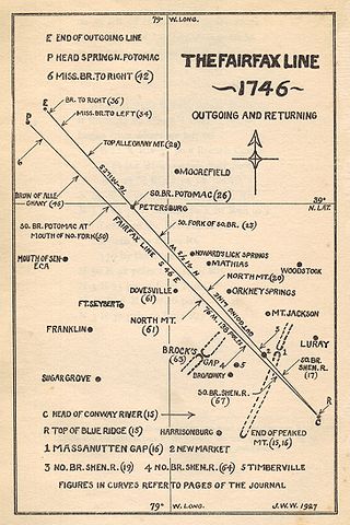
The Fairfax Line was a surveyor's line run in 1746 to establish the limits of the "Northern Neck land grant" in colonial Virginia.

William Fairfax (1691–1757) was a political appointee of the British Crown in several colonies as well as a planter and politician in the Colony of Virginia. Fairfax served as Collector of Customs in Barbados, Chief Justice and governor of the Bahamas; and Customs agent in Marblehead, Massachusetts, before being reassigned to the Colony of Virginia.
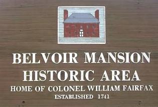
Belvoir was the plantation and estate of colonial Virginia's prominent William Fairfax family. Operated with the forced labor of enslaved people, it was located on the west bank of the Potomac River on the present site of Fort Belvoir in Fairfax County, Virginia.
Maryland v. West Virginia, 217 U.S. 1 (1910), is a 9-to-0 ruling by the United States Supreme Court which held that the boundary between the American states of Maryland and West Virginia is the south bank of the North Branch Potomac River. The decision also affirmed criteria for adjudicating boundary disputes between states, which said that decisions should be based on the specific facts of the case, applying the principles of law and equity in such a way that least disturbs private rights and title to land.
William Beverley (1696–1756) was an 18th-century legislator, civil servant, planter and landowner in the Colony of Virginia. Born in Virginia, Beverley—the son of planter and historian Robert Beverley, Jr. and his wife, Ursula Byrd Beverley (1681–1698)—was the scion of two prominent Virginia families. He was the nephew of Peter Beverley (1668–1728), Speaker of the Virginia House of Burgesses, and the grandson of wealthy Virginia planter William Byrd I (1652–1704) of Westover Plantation. Beverley's mother died shortly before her 17th birthday, and he was sent to England.