Kamma is a largely Hindu caste from South India. The community of Kammas is believed to have originated from agriculturists of the Kammanadu region of the erstwhile Guntur district and Ongole division in Andhra Pradesh. Propelled by their military activity in the Vijayanagara Empire, Kammas are believed to have spread out from the region during the Vijayanagara period, followed by some in-migration during the British period and out-migration again during the twentieth century. Today they are regarded as the richest group in Andhra Pradesh and are a dominant caste from Coastal Andhra with socio-economic and political prominence throughout the Telugu-speaking regions of India.

Krishna district is a district in the coastal Andhra Region in Indian state of Andhra Pradesh, with Machilipatnam as its administrative headquarters. It is surrounded on the East by Bay of Bengal, West by Guntur, Bapatla and North by Eluru and NTR districts and South again by Bay of Bengal.

Coastal Andhra or Kosta Andhra is a geographic region in the States and union territories of India of Andhra Pradesh. Vijayawada is the largest city in this region. Region share borders with Uttarandhra, Rayalaseema and Telangana. It was part of Madras State before 1953 and Andhra State from 1953 to 1956. According to the 2011 census, it has an area of 91,915 square kilometres (35,489 sq mi) which is 57.99% of the total state area and a population of 34,193,868 which is 69.20% of Andhra Pradesh state population. This area includes the coastal districts of Andhra Pradesh on the Circar Coast between the Eastern Ghats and the Bay of Bengal, from the northern border with Odisha to Rayalaseema in the south.

The West Godavari district is a coastal district in the Indian state of Andhra Pradesh with an administrative headquarters in Bhimavaram. As of the 2011 Census of India, the district has an area of 2,178 km2 (841 sq mi) and a population of 1,779,935. It is bounded by the Krishna district and Bay of Bengal to the south, East Godavari district to the east, and Eluru district, Kolleru Lake and Upputeru Drain to the northwest.

Guntur district is one of the twenty six districts in the Coastal Andhra region of the Indian state of Andhra Pradesh. The administrative seat of the district is located at Guntur, the largest city of the district in terms of area and with a population of 670,073. It has a coastline of approximately 100 km (62 mi) on the right bank of Krishna River, that separates it from Krishna district and NTR district. It is bounded on the south by Bapatla district and on the west by Palnadu district. It has an area of 2,443 km2 (943 sq mi), with a population of 20,91,075, as per 2011 census of India.
Kapu is a Hindu caste mainly found in the Indian state of Andhra Pradesh. They are classified as a Forward caste. They are a community of land-owning agriculturists. Historically, they have also been warriors and military generals (Nayakas) in Hindu armies. They are a dominant caste of Andhra Pradesh. Kapus commonly carry the title Naidu. They are primarily present in Coastal Andhra with major concentration in the Godavari-Krishna delta region.
Kammanadu is a historical region in the Indian state of Andhra Pradesh. It consisted of parts of the present day Guntur and Prakasam districts.
Telaga is a community found in Coastal Andhra region of India. Telaga is a subcaste of Kapu and both terms are often used synonymously. They are classified as a Forward caste. They are a land-owning agrarian community. Historically, they were a warrior caste known for their honour and bravery.
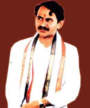
Vangaveeti Mohana Ranga Rao was an Indian politician from Andhra Pradesh. He represented Vijayawada East assembly constituency as a member of Indian National Congress.
Raavi (రావి) is one of the surnames in Brahmin and Kamma caste. Raavi is the Telugu word for Peepal Tree.

Andhra Pradesh lies between 12°41' and 19.07°N latitude and 77° and 84°40'E longitude, and is bordered by Telangana to the north and west, Chhattisgarh to the north-west, Orissa to the north, the Bay of Bengal to the east, Tamil Nadu to the south and Karnataka to the southwest and west. Andhra Pradesh has a coastline of around 974 km, which gives it the second longest coastline in the nation. Two major rivers, the Godavari and the Krishna run across the state. A small enclave 12 sq mi (30 km²), the Yanam district of Puducherry, lies in the Godavari Delta in the north east of the state. The state includes the eastern part of Deccan plateau as well as a considerable part of the Eastern Ghats.
Relli is a social group of South Indians who reside in the Indian states of Andhra Pradesh, Odisha, West bengal, and Chhattisgarh. They are classified as a Scheduled Caste.
Nadu a term used to mean land, country, place, domicile, etc. in Dravidian languages.
Vankayala is an Indian surname.
Rayavaram may refer to places in India:
Chowdavaram may refer to:
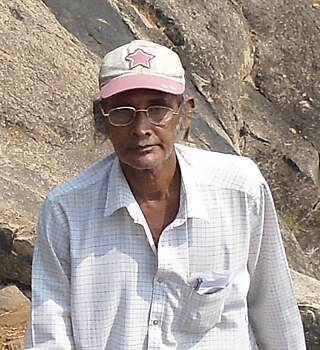
Kadiyala Venkateswara Rao is a retired sports Deputy director in Sports Authority of Andhra Pradesh, a professional freelance-archaeologist. He hails from Tenali in Guntur district, Andhra Pradesh. He is credited with the exploration and identification of a large number of prehistoric and Buddhist sites in Andhra Pradesh in the recent years. (2010–2014)
National Highway 216 is a National Highway in the Indian state of Andhra Pradesh. The former highways of NH 214 and 214A were merged and renumbered as NH 216. It starts from NH 16 junction at Kattipudi and passes through Kakinada, Amalapuram, Digamarru (Palakollu), Narasapuram, Machilipatnam, Repalle, Cherukupalle, Bapatla, Chirala before it junctions NH 16 again at Ongole. Visakhapatnam–Kakinada Petro Chemical Corridor, is a proposed project along the highway.