
Bass Strait is a strait separating the island state of Tasmania from the Australian mainland. The strait provides the most direct waterway between the Great Australian Bight and the Tasman Sea, and is also the only maritime route into the economically prominent Port Phillip Bay.
Long Island is a densely populated island in the southeastern geographical area of the State of New York.
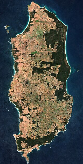
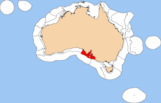
King Island is an island in the Bass Strait, belonging to the Australian state of Tasmania. It is the largest of four islands known as the New Year Group and the second-largest island in Bass Strait. The island's population at the 2016 census was 1,585 people, up from 1,566 in 2011. The local government area of the island is the King Island Council.

The Furneaux Group is a group of approximately 100 islands located at the eastern end of Bass Strait, between Victoria and Tasmania, Australia. The islands were named after British navigator Tobias Furneaux, who sighted the eastern side of these islands after leaving Adventure Bay in 1773 on his way to New Zealand to rejoin Captain James Cook. Navigator Matthew Flinders was the first European to explore the Furneaux Islands group, in the Francis in 1798, and later that year in the Norfolk.
Green Island or Greene Island can refer to:
The Bass Strait Triangle is the waters that separate the states of Victoria and Tasmania, including Bass Strait, in south-eastern Australia. The term Bass Strait Triangle appears to have been first used following the disappearance of Frederick Valentich in 1978 although the region had a bad reputation long before that.
Seal Island, Seal Islands and similar may refer to:
A sugarloaf is refined sugar in the form of a rounded cone, the most common way of distributing sugar until the late 19th century.

Hogan Island, the largest island of the Hogan Group, is a 232-hectare (570-acre) granite island, located in northern Bass Strait, that lies between the Furneaux Group in north-east Tasmania, and Wilsons Promontory in Victoria, Australia. The island has a maximum elevation of 116 metres (381 ft) AHD .

The Bass Strait Shelf Province is a biogeographic region of Australia's coastal and continental shelf waters. It covers the central Bass Strait between Tasmania and the southern Australian mainland. It is a provincial level bioregion in the Integrated Marine and Coastal Regionalisation of Australia (IMCRA) system. The Bassian and adjacent Tasmanian Shelf provinces correspond to the Bassian marine ecoregion in the WWF's Marine Ecoregions of the World system.
The Spencer Gulf Shelf Province, also known as the South Australian Gulfs marine ecoregion, is a biogeographic region of Australia's continental shelf and coastal waters. It includes the warm temperate coastal waters of South Australia's central coast. It is a provincial bioregion in the Integrated Marine and Coastal Regionalisation of Australia (IMCRA) system.
This outline of Australia is an overview of and topical guide to various aspects of the country of Australia.

Vansittart Island, also known as Gun Carriage Island, is a granite island with an area of 800 hectares. The island is part of Tasmania's Vansittart Island Group, lying in eastern Bass Strait between Flinders and Cape Barren Islands in the Furneaux Group.
Jack Kenneth Loney was an amateur Australian maritime historian who published over one hundred books and numerous newspaper and magazine articles. He was a schoolteacher and principal until his retirement. He became interested in maritime history after preparing several general history booklets covering the Otway region of western Victoria, Australia.
The Hogan Group is a collection of six islands and islets located in the Bass Strait that define part of the border between mainland Australia and the island state of Tasmania. Within the jurisdiction of Tasmania, the Hogan Group forms a land border between the states of Tasmania and Victoria. The island group is officially designated unallocated Crown land, within the Flinders Municipality in Tasmania and the South Gippsland Shire in Victoria.
This page is based on this
Wikipedia article Text is available under the
CC BY-SA 4.0 license; additional terms may apply.
Images, videos and audio are available under their respective licenses.