
Nigeria, officially the Federal Republic of Nigeria, is a country in West Africa. It is situated between the Sahel to the north and the Gulf of Guinea to the south in the Atlantic Ocean. It covers an area of 923,769 square kilometres (356,669 sq mi), and with a population of over 230 million, it is the most populous country in Africa, and the world's sixth-most populous country. Nigeria borders Niger in the north, Chad in the northeast, Cameroon in the east, and Benin in the west. Nigeria is a federal republic comprising 36 states and the Federal Capital Territory, where the capital, Abuja, is located. The largest city in Nigeria is Lagos, one of the largest metropolitan areas in the world and the largest in Africa.
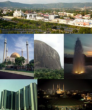
Abuja is the capital and eighth most populous city of Nigeria. Situated at the centre of the country within the Federal Capital Territory (FCT), it is a planned city built mainly in the 1980s based on a master plan by International Planning Associates (IPA), a consortium of three American planning and architecture firms made up of Wallace, Roberts, McHarg & Todd as the lead, Archi systems International, and Planning Research Corporation. The Central Business District of Abuja was designed by Japanese architect Kenzo Tange. It replaced Lagos, the country's most populous city, as the capital on 12 December 1991.
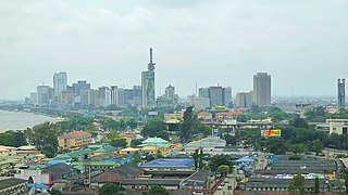
Lagos or Lagos City is the most populous city in Nigeria, with an estimated population of 21 million in 2015. The estimated population for Lagos was more than 26 million in 2023; and around 30 million for the Lagos metropolitan area. Lagos is the most populous urban area in Africa. Lagos was the national capital of Nigeria until December 1991 following the government's decision to move their capital to Abuja in the centre of the country. Lagos is a major African financial centre and is the economic hub of Lagos State and Nigeria at large. The city has been described as the cultural, financial, and entertainment capital of Africa, and is a significant influence on commerce, entertainment, technology, education, politics, tourism, art, and fashion. Lagos is also among the top ten of the world's fastest-growing cities and urban areas. The megacity has the fourth-highest GDP in Africa and houses one of the largest and busiest seaports on the continent. The Lagos metropolitan area is a major educational and cultural centre in Sub Saharan Africa. Due to the large urban population and port traffic volumes, Lagos is classified as a Medium-Port Megacity.

A planned community, planned city, planned town, or planned settlement is any community that was carefully planned from its inception and is typically constructed on previously undeveloped land. This contrasts with settlements that evolve organically.

Kogi State is a state in the North Central region of Nigeria, bordered to the west by the states of Ekiti and Kwara, to the north by the Federal Capital Territory, to the northeast by Nasarawa State, to the northwest by Niger State, to the southwest by the Edo and Ondo states, to the southeast by the states of Anambra and Enugu, and to the east by Benue State. It is the only state in Nigeria to border ten other states. Named for the Hausa word for river (Kogi). Kogi State was formed from parts of Benue State, Niger State, and Kwara State on 27 August 1991. The state is nicknamed the "Confluence State" due to the fact that the confluence of the River Niger and the River Benue occurs next to its capital, Lokoja.

Ibadan is the capital and most populous city of Oyo State, in Nigeria. It is the third-largest city by population in Nigeria after Lagos and Kano, with a total population of 3,649,000 as of 2021, and over 6 million people within its metropolitan area. It is the country's largest city by geographical area. At the time of Nigeria's independence in 1960, Ibadan was the largest and most populated city in the country, and the second most populous in Africa behind Cairo. Ibadan is ranked the second fastest growing city on the African continent according to the UN Human settlements research program (2022). It is also ranked third in West Africa in the tech startups index. Ibadan joined the UNESCO Global Network of Learning Cities in 2016.

Lagos State is a state in southwestern Nigeria. Of the 36 states, it is both the most populous and smallest in area. Bounded to the south by the Bight of Benin and to the west by the international border with Benin, Lagos State borders Ogun State to the northeast making it the only Nigerian state to border only one other state. Named for the city of Lagos—the most populous city in Africa—the state was formed from the Western Region and the former Federal Capital Territory on 27 May 1967.

Victoria Island (VI) is an affluent area that encompasses a former island of the same name neighbouring Lagos Island, Ikoyi and the Lekki Peninsula by the Lagos Lagoon. It is the main business and financial centre of Lagos State, Nigeria. Victoria Island is one of the most exclusive and expensive areas to reside in Lagos. The town and island lie within the boundaries of the Eti-Osa Local Government Area (LGA).
The Federal Capital Territory (FCT) is a federal territory in central Nigeria. Abuja, the capital city of Nigeria, is located in this territory. The FCT was formed in 1976 from parts of the states of old Kaduna, Kwara, Niger, and Plateau states, with the bulk of land mass carved out of Niger state. The Federal Capital Territory is within the North Central region of the country. Unlike other states of Nigeria, which are headed by elected Governors, it is administered by the Federal Capital Territory Administration, headed by a minister, who is appointed by the president.

Nasarawa State is a state in the North Central region of Nigeria, bordered to the east by the states of Taraba and Plateau, to the north by Kaduna State, to the south by the states of Benue and Kogi, and to the west by the Federal Capital Territory. Named for the historic Nasarawa Emirate, the state was formed from the west of Plateau State on 1 October 1996. The state has thirteen local government areas and its capital is Lafia, located in the east of the state, while a key economic centre of the state is the Karu Urban Area—suburbs of Abuja—along the western border with the FCT.
The Gbagyi or Gbari are an ethnic group found predominantly in Central Nigeria, with an estimated population figure put at 5.8 million, spread in four States, including the FCT, and located in thirty local Government areas, according to the 2006 National Population Census figures. It is also the name of their language. Members of the ethnic group speak two dialects. While speakers of the dialects were loosely called Gwari by both the Hausa Fulani and Europeans during pre-colonial Nigeria they prefer to be known as Gbagyi/Gbari. They live in the Niger, the Federal Capital Territory - Abuja, and Kaduna State. They are also found in Nasarawa central Nigeria Area. Gbagyi/Gbari is one of the most populated ethnic groups in the middle belt and indigenous in the Federal Capital Territory of Nigeria. This means Gbagyi people are the bonafide owners of the Nigerian capital city, Abuja.
Federal Republic of Nigeria – sovereign country located in West Africa. Nigeria is a federal constitutional republic comprising thirty-six states and one Federal Capital Territory. Nigeria borders the Republic of Benin in the west, Chad and Cameroon in the east, and Niger in the north. Its coast lies on the Gulf of Guinea, part of the Atlantic Ocean, in the south. The capital of Nigeria is Abuja.
Mararaba is a town in Nasarawa State, central Nigeria. It is a district of Karu Local Government Area, Nasarawa State and is among the towns that make up the Karu urban area, a conurbation of towns stretching to Nigeria's Federal Capital Territory. Its neighbouring towns are:

Abuja Rail Mass Transit commonly known as Abuja Light Rail is an abandoned regional rail transport system in the Federal Capital Territory of Nigeria. It was the first rapid transit system in the country, West Africa, and the second such system in sub-saharan Africa. The first phase of the project connects the city center to Nnamdi Azikiwe International Airport, stopping at the Abuja-Kaduna Railway station in Idu. The Abuja Metro Line was launched on 12 July 2018 and a three-trains-per-day service opened for passengers the following week. Passenger services on the line were suspended in early 2020 due to the COVID-19 pandemic, and had still not resumed as of September 2023.
The Karu Urban Area is an urban area in central Nigeria. The urban area is majorly located in the Nigerian state of Nasarawa, but with some parts stretching into the boundaries of the Federal Capital Territory (FCT). It has an area of 40,000 hectares (400 km2) and a population of some 2 million.
Auta Balefi is a fast developing district in central Nigeria. This town is located in Karu Local Government Area of Nasarawa State. It lies close to Abuja, the capital city of Nigeria in the Federal Capital Territory of Nigeria. Popular institutions located in this town include, Birgham University Campus (ECWA); Living Faith Church, Goshen City; The Redeemed Christian Church of God, Redemption Camp, Auta gurgu; and some developing estates. This district is rapidly growing due to its closeness to the Federal Capital Territory, Abuja.

Urban rail transit in Africa has emerged as a growing form of transit due to rapid urbanization that has occurred in recent decades across the continent. Some of these transit systems are older and more developed, such as the metro in Cairo which opened in 1987. Others such as the light-rail system in Addis Ababa are much more recent, which opened in 2015. A variety of technologies are being used ranging from light-rail, bus rapid-transit, and commuter-rail etc. Africa for several decades saw minimal investment in rail infrastructure, but in recent years due to urban population growth and improved financing options, investment in rail networks has increased.

New Karshi is a town in Karu Local Government Area of Nasarawa State, Nigeria, founded in the 1980s by Muhammadu Bako II. It is a semi-autonomous local government created out of Karu LGA as Karshi Development area with the administrative secretariat in Uke. Karshi has a local government chairman as its administrative head and a seat in the Nasarawa State House of Assembly. Emir of Karshi Emirate, Alhaji (Dr) Muhammadu Sani Bako III, a first class chief is the traditional head of New Karshi. It has a population of about 30,000 people. The predominant tribes are Gwandara, Gbagyi, Gade, Bassa and Hausa.
Gwarimpa Estate is a developed district situated in Phase 3, in the capital city of Nigeria, Abuja. It is the largest single housing estate in Nigeria and in West Africa. The mega housing estate consist of some of the most elegant architectural designs with good roads networks and expensive houses.