Kattenvenne

Last updated

Kattenvenne is a village in Germany (North Rhine-Westphalia) about 23 km northeast from Münster. It is part of the municipality Lienen.

North Rhine-Westphalia State in Germany

North Rhine-Westphalia is a state of Germany.

Münster Place in North Rhine-Westphalia, Germany

Münster is an independent city in North Rhine-Westphalia, Germany. It is in the northern part of the state and is considered to be the cultural centre of the Westphalia region. It is also capital of the local government region Münsterland. Münster was the location of the Anabaptist rebellion during the Protestant Reformation and the site of the signing of the Treaty of Westphalia ending the Thirty Years' War in 1648. Today it is known as the bicycle capital of Germany.

Lienen Place in North Rhine-Westphalia, Germany

Lienen is a municipality in the district of Steinfurt, in North Rhine-Westphalia, Germany. It is situated approximately 15 km south-east of Osnabrück and 30 km north-east of Münster.

Contents

History

The name Kattenvenne is first mentioned in a contract of the year 836 in which it is called "Hadunveni"(Latin). A second mentioning is found in a document of 1312. In the Middle Ages Kattenvenne was known for its peat moors. In the 18th century 23 farms were documented here.

Middle Ages Period of European history from the 5th to the 15th century

In the history of Europe, the Middle Ages lasted from the 5th to the 15th century. It began with the fall of the Western Roman Empire and merged into the Renaissance and the Age of Discovery. The Middle Ages is the middle period of the three traditional divisions of Western history: classical antiquity, the medieval period, and the modern period. The medieval period is itself subdivided into the Early, High, and Late Middle Ages.

Peat accumulation of partially decayed vegetation

Peat, also known as turf, is an accumulation of partially decayed vegetation or organic matter. It is unique to natural areas called peatlands, bogs, mires, moors, or muskegs. The peatland ecosystem is the most efficient carbon sink on the planet, because peatland plants capture CO2 naturally released from the peat, maintaining an equilibrium. In natural peatlands, the "annual rate of biomass production is greater than the rate of decomposition", but it takes "thousands of years for peatlands to develop the deposits of 1.5 to 2.3 m [4.9 to 7.5 ft], which is the average depth of the boreal [northern] peatlands". Sphagnum moss, also called peat moss, is one of the most common components in peat, although many other plants can contribute. The biological features of Sphagnum mosses act to create a habitat aiding peat formation, a phenomenon termed 'habitat manipulation'. Soils consisting primarily of peat are known as histosols. Peat forms in wetland conditions, where flooding or stagnant water obstructs the flow of oxygen from the atmosphere, slowing the rate of decomposition.

Moorland type of habitat found in upland areas with (sometimes marshy) poor acid soil and overgrown with low vegetation

Moorland or moor is a type of habitat found in upland areas in temperate grasslands, savannas, and shrublands and montane grasslands and shrublands biomes, characterised by low-growing vegetation on acidic soils. Moorland nowadays generally means uncultivated hill land, but includes low-lying wetlands. It is closely related to heath although experts disagree on precisely what distinguishes the types of vegetation. Generally, moor refers to highland, high rainfall zones, whereas heath refers to lowland zones which are more likely to be the result of human activity.

The very first development of the village followed the construction of the railroad between Münster and Osnabrück (1868–1871). Some prisoners of the French-German War (1870) must have been working here, too. In 1873 the Kattenvenne railway station was built. The first stone of the church was laid in 1887 and the building was finished in the following year. Already at Christmas 1887 the first service was held in the unfinished building by Pastor Philipps. In 1897 a tower was added on the front of the church. Since the end of the 19th century economy developed rapidly. As a consequence the population more than tripled within the next 130 years, even though 400 persons emigrated to North America and 230 died in the two world wars.

Osnabrück Place in Lower Saxony, Germany

Osnabrück is a city in the federal state of Lower Saxony in north-west Germany. It is situated in a valley penned between the Wiehen Hills and the northern tip of the Teutoburg Forest. With a population of 168,145 Osnabrück is one of the four largest cities in Lower Saxony. The city is the centrepoint of the Osnabrück Land region as well as the District of Osnabrück.

Sports

The Kattenvenne handball team TVK 1927 plays in the North Rhine-Westphalia Pampers League.

Related Research Articles

Westphalia State part and historic region of North Rhine-Westphalia in Germany

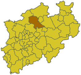
Westphalia is a region in northwestern Germany and one of the three historic parts of the state of North Rhine-Westphalia. It has an area of 20,208 km2 (7,802 sq mi) and 7.9 million inhabitants.

Nienburg (district) District in Lower Saxony, Germany

Nienburg is a district (Landkreis) in Lower Saxony, Germany. It is bounded by the districts of Diepholz, Verden, Heidekreis, Hanover and Schaumburg, and by the state of North Rhine-Westphalia.

Gelsenkirchen Place in North Rhine-Westphalia, Germany

Gelsenkirchen is the 11th largest city of Germany's most populous federal state of North Rhine-Westphalia and its 262,528 (2016) inhabitants make it the 25th largest city of Germany. On the Emscher River, it lies at the centre of the Ruhr, the largest urban area of Germany, of which it is the fifth largest city after Dortmund, Essen, Duisburg and Bochum. The Ruhr is located in the Rhine-Ruhr Metropolitan Region, one of Europe's largest urban areas. Gelsenkirchen is the fifth largest city of Westphalia after Dortmund, Bochum, Bielefeld and Münster, and it is one of the southernmost cities in the Low German dialect area. The city is home to the famous football club Schalke 04, which is named after Gelsenkirchen-Schalke. The club's stadium Veltins-Arena, however, is located in Gelsenkirchen-Erle.

Coesfeld (district) District in North Rhine-Westphalia, Germany

Coesfeld is a Kreis (district) in the northwestern part of North Rhine-Westphalia, Germany, west of the city of Münster. Neighboring districts are Steinfurt, district-free Münster, Warendorf, district-free Hamm, Unna, Recklinghausen, Borken.

Mesum human settlement in Germany

Mesum is a village south of Rheine, located in the district Steinfurt, part of North Rhine-Westphalia. The current population in 2004 is about 8500. Mesum was first mentioned in 1373 in a document listing the church. That old church still exists as the oldest building of the village.

Höxter Place in North Rhine-Westphalia, Germany

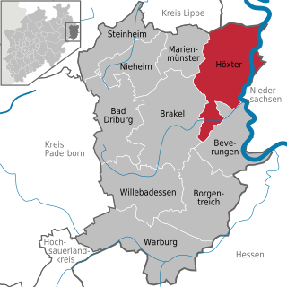
Höxter is a town in eastern North Rhine-Westphalia, Germany on the left bank of the river Weser, 52 km north of Kassel in the centre of the Weser Uplands. The main town's population is around 15,000, and with outlying centres, about 30,000. It is the seat of the Höxter district.

Halle (Westfalen) Place in North Rhine-Westphalia, Germany

Halle, officially Halle (Westf.) or Halle Westfalen to distinguish it from the larger Halle (Saale), is a town in the German Bundesland of North Rhine-Westphalia, 15 km west of Bielefeld, and belongs to the district of Gütersloh in the region of Detmold.

Werne Place in North Rhine-Westphalia, Germany

Werne is a town in the Federal state of North Rhine-Westphalia in the Unna district in Germany. It is located on the southern edge of the Münsterland region near the Ruhrgebiet. The population of Werne is about 32,000.

Werden Abbey abbey

Werden Abbey was a Benedictine monastery in Essen-Werden (Germany), situated on the Ruhr.

Kaarst Place in North Rhine-Westphalia, Germany

Kaarst is a town in Germany. It lies in the district of Rhein-Kreis Neuss in North Rhine-Westphalia. It is 5 km west of Neuss and 12 km east of Mönchengladbach.

Wettringen (Münsterland) Place in North Rhine-Westphalia, Germany

Wettringen is a village and a municipality in the district of Steinfurt, in North Rhine-Westphalia, Germany.

Ochtrup Place in North Rhine-Westphalia, Germany

Ochtrup is a town in the district of Steinfurt, in North Rhine-Westphalia, Germany. It is situated approximately 20 km west of Rheine and 20 km east of Enschede.

Ostbevern Place in North Rhine-Westphalia, Germany

Ostbevern is a municipality in the district of Warendorf, in North Rhine-Westphalia, Germany.

Liesborn Abbey was a Benedictine monastery in Liesborn, in what was originally the Dreingau, now a part of Wadersloh in the district of Warendorf in North Rhine-Westphalia, Germany.

Kinderhaus is a district of Münster, a city in North Rhine-Westphalia, Germany. It lies approximately 4 km to the north of the centre of Münster and belongs to the borough Münster-Nord, together with Coerde and Sprakel. It has 16,000 inhabitants and is mainly a residential area, though it has attracted some service enterprises, primarily in a large strip mall surrounding the Bürgerzentrum.

Kattenvenne is a village located in North Rhine-Westphalia, Germany.

Ravensberg Basin geographic region

The Ravensberg Basin or Ravensberg Hills is a natural region in the governorate of Detmold (Ostwestfalen-Lippe) in the northeastern part of the German state of North Rhine-Westphalia; small elements also fall within the neighbouring state of Lower Saxony. It is part of the lower Weser Uplands and includes the hilly basin country between the Wiehen Hills in the north, Lippe Uplands in the east, Teutoburg Forest in the south and Osnabrück Hills in the west. The heart of the Ravensberg Basin is almost coincident with the cultural region of the Ravensberg Land.

Ravensberg Land

Ravensberg Land is a cultural landscape in the district of Ostwestfalen-Lippe in the northeast of the German federal state of North Rhine-Westphalia. It lies between the Wiehen Hills to the north, the Teutoburg Forest to the south, the state border with Lower Saxony to the west and the large bend in the River Weser and the boundary of Lippe district to the east. It thus essentially encompasses the Westphalian part of the Ravensberg Hills. The most important towns are Bielefeld, Herford, Bad Oeynhausen and Bünde.

Witzhelden human settlement in Germany

Witzhelden is a small town located in the district of Leichlingen near the cities of Düsseldorf, Solingen, and Cologne in the state of North Rhine-Westphalia in Germany.

References

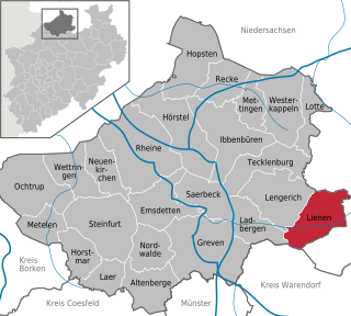
Hunsche F.E.: Lienen am Teutoburger Wald; Lengericher Handelsdruckerei, 1965.

Coordinates: 52°07′N7°52′E / 52.117°N 7.867°E / 52.117; 7.867

Geographic coordinate system Coordinate system

A geographic coordinate system is a coordinate system that enables every location on Earth to be specified by a set of numbers, letters or symbols. The coordinates are often chosen such that one of the numbers represents a vertical position and two or three of the numbers represent a horizontal position; alternatively, a geographic position may be expressed in a combined three-dimensional Cartesian vector. A common choice of coordinates is latitude, longitude and elevation. To specify a location on a plane requires a map projection.