College station or College Station may refer to:

Finch Avenue is an arterial thoroughfare that travels east–west in Toronto, Ontario, Canada. The road continues west into the Regional Municipality of Peel as Regional Road 2 and east into the Regional Municipality of Durham as Regional Road 37.

St. George is a station on Line 1 Yonge–University and Line 2 Bloor–Danforth of the Toronto subway. It is located north of Bloor Street West between St. George Street and Bedford Road. It is the second-busiest station in the system after Bloor–Yonge station, serving a combined total of approximately 136,050 people a day. Wi-Fi service is available at this station.

St. Clair is a subway station on Line 1 Yonge–University in Toronto, Ontario, Canada. The station opened in 1954 as part of the original Yonge Street subway.

Jane is a subway station on Line 2 Bloor–Danforth of the Toronto subway in Toronto, Ontario, Canada. It is located just north of Bloor Street West, spanning the block east of Jane Street to Armadale Avenue, with entrances from all three streets. It opened in 1968 as part of the westerly extension from Keele to Islington Station. Wi-Fi service is available at this station.

High Park is a subway station on Line 2 Bloor–Danforth of the Toronto subway in Toronto, Ontario, Canada. It is located just north of Bloor Street West, spanning the block east of Quebec Avenue to High Park Avenue. It opened in 1968 as part of the westerly extension from Keele to Islington station. Wi-Fi service is available at this station.

Dundas West is a subway station on Line 2 Bloor–Danforth of the Toronto subway in Toronto, Ontario, Canada. It is located just north of Bloor Street West at the corner of Dundas Street and Edna Avenue. The station is about 200 metres west of Bloor GO Station on the GO Transit Kitchener line and the Union Pearson Express.

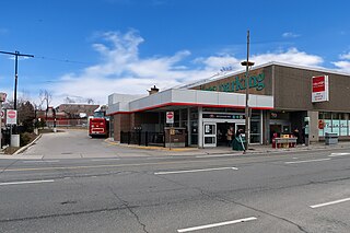
Keele is a subway station on Line 2 Bloor–Danforth of the Toronto subway in Toronto, Ontario, Canada. It is located just north of Bloor Street West on the east side of Keele Street. The station opened in 1966, and was the western terminus of the line until 1968. Wi-Fi service is available at this station.
Woodbine is a subway station on Line 2 Bloor–Danforth in Toronto, Ontario, Canada. The station is at the southeast corner of Woodbine Avenue and Strathmore Boulevard, just north of Danforth Avenue.
The Eglinton West line was a proposed east–west subway line in Toronto, Ontario, Canada, whose construction began in 1994 but was cancelled in 1995. It was to start from the existing Eglinton West station on the Toronto Transit Commission's Yonge–University–Spadina line, travel underneath Eglinton Avenue West, and terminate at Black Creek Drive in its initial phase.

Bloor Street is a major east–west residential and commercial thoroughfare in Toronto, Ontario, Canada. Bloor Street runs from the Prince Edward Viaduct, which spans the Don River Valley, westward into Mississauga where it ends at Central Parkway. East of the viaduct, Danforth Avenue continues along the same right-of-way. The street, approximately 25 kilometres (16 mi) long, contains a significant cross-sample of Toronto's ethnic communities. It is also home to Toronto's famous shopping street, the Mink Mile.

Sheppard Avenue is an east–west principal arterial road in Toronto, Ontario, Canada. The street has two distinct branches near its eastern end, with the original route being a collector road leading to Pickering via a turnoff, and the main route following a later-built roadway which runs south to Kingston Road. To avoid name duplication, the Toronto portion of the northern branch was renamed Twyn Rivers Drive. The section of the street entirely in Toronto is (34.2 km) in length, while the Pickering section and Twyn Rivers Dr. is (5.4 km) long.

Finch West is a subway station on the Line 1 Yonge–University of the Toronto subway. It is located under Keele Street, north of Finch Avenue West. When Line 6 Finch West opens in the fourth quarter of 2024, it will serve as the eastern terminus of that line.

York University is a subway station on Line 1 Yonge–University of the Toronto subway. It is located on the main Keele Campus of York University, near Ian Macdonald and York Boulevards in the former city of North York. It opened in 2017, as part of the extension of the subway to Vaughan Metropolitan Centre.

Pioneer Village is a subway station on the Line 1 Yonge–University of the Toronto subway. It is located under the intersection of Northwest Gate and Steeles Avenue, at the city boundaries of Toronto and Vaughan, Ontario, Canada. A Toronto Transit Commission (TTC) bus terminal is connected to the southern portion of the station, and there is a regional bus terminal, the Pioneer Village Terminal, for connecting to York Region Transit (YRT) buses on the north side of Steeles Avenue. Pioneer Village, Highway 407 and Vaughan Metropolitan Centre stations are the first Toronto subway stations fully or partially located outside the Toronto city limits since its last amalgamation in 1998.

Rockcliffe–Smythe is a neighbourhood in Toronto, Ontario, Canada. It was developed after World War II as part of the urbanization of the former suburb of York Township. It is in Ward 5 in the City of Toronto.

High Park North, or often simply High Park, after the park, is a neighbourhood in Toronto, Ontario, Canada. It is bounded on the south by Bloor Street, on the west by Runnymede Road, on the north by Annette Street, Quebec Avenue and Humberside Avenue, and on the east by the GO Transit Weston Subdivision rail tracks. It is located in the Parkdale—High Park provincial and federal electoral districts. The area east of Keele Street is also known informally as the "West Bend" neighbourhood.

Keelesdale is an underground light rail transit (LRT) station under construction on Line 5 Eglinton, a new line that will be part of the Toronto subway system. It will be located in the Silverthorn neighbourhood at the intersection of Keele Street and Eglinton Avenue and is scheduled to open in 2024. Nearby destinations include the York Civic Centre, Keelesdale Park and Chris Tonks Arena, York Memorial Collegiate Institute, George Harvey Collegiate Institute, and the Silverthorn neighbourhood.

Keele Yard is a rail yard on the Toronto Transit Commission's (TTC's) Line 2 Bloor–Danforth of the Toronto subway system. Keele Yard is located between Dundas West and Keele stations.