This page is based on this
Wikipedia article Text is available under the
CC BY-SA 4.0 license; additional terms may apply.
Images, videos and audio are available under their respective licenses.

Bridgend is a town in Bridgend County Borough in Wales, 20 miles (32 km) west of the capital Cardiff and 20 miles (32 km) east of Swansea. The river crossed by the original bridge, which gave the town its name, is the River Ogmore, but the River Ewenny also passes to the south of the town.

Bridgend is a county borough in southern Wales, UK. The county borough has a total population of 139,200 people, and contains the town of Bridgend, after which it is named. Its members of the National Assembly for Wales are Carwyn Jones AM, the former First Minister of Wales and Huw Irranca-Davies AM representing the Ogmore Constituency, and its Members of Parliament are Madeleine Moon and Chris Elmore.

Pyle is a village and community in Bridgend county borough, Wales. This large village is served by the A48 road, and lies less than one mile from Junction 37 of the M4 motorway, and is therefore only a half-hour journey from the capital city of Wales, Cardiff; in fact it lies approximately equidistant between the capital (Cardiff) and the second city (Swansea). The nearest town is the seaside resort of Porthcawl. Within the Community, to the northeast of Pyle, is the adjoining settlement of Kenfig Hill.

Aberkenfig is a village located in the County Borough of Bridgend, Wales to the north of Bridgend town. The community population is shown under Newcastle North.
Cornelly is a community and electoral ward in Bridgend County Borough, South Wales. In 2011, the population of the Cornelly ward was 7,059.
North Cornelly is a village in Cornelly, Bridgend county borough, Wales. The village is close to South Cornelly, Pyle and Porthcawl, and junction 37 of the M4 motorway, which runs along its southern side.

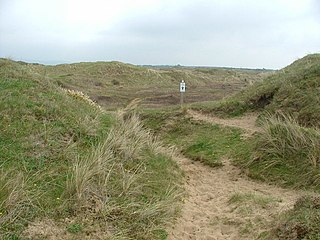
Kenfig Pool is a national nature reserve situated near Porthcawl, Bridgend. Wild storms and huge tides between the 13th and 15th centuries are mainly responsible for creating the Kenfig dunes near Porthcawl, as they threw vast quantities of sand up over the Glamorgan coast. This buried the nearby borough of Kenfig, and its castle, of which only the ruined keep survives. At 70 acres the second largest freshwater lake in south Wales. Kenfig Pool lies at the heart of the national nature reserve and is a valuable stopping point for migrating birds. The lake's maximum depth is about 12 feet. An island, built by the aristocrats living in nearby Margam to encourage wildfowl to nest there, has long since sunk beneath the waters.
South Cornelly is a village in Cornelly, Bridgend county borough, Wales. The village is close to North Cornelly, Pyle and Porthcawl, and junction 37 of the M4 motorway, which runs along its northern side. It is in the historic county of Glamorgan.
The River Kenfig is a river in Wales, straddling the county boroughs of Neath Port Talbot and Bridgend. It is approximately 18 kilometres long.

Newcastle is an area and electoral ward of the town of Bridgend, Wales. The area includes the medieval Newcastle Castle. The ward elects councillors to Bridgend Town Council and Bridgend County Borough Council.

Bridgend is a community in Bridgend County Borough, south Wales. Along with the communities of Brackla and Coychurch Lower, it makes up the town of Bridgend. Bridgend is the western district of Bridgend town, and takes in the town centre, Newcastle Hill, Tremains and to the north Wild Mill. The population of the community of Bridgend at the 2001 census was 13,950.

In the United Kingdom, the term listed building refers to a building or other structure officially designated as being of special architectural, historical, or cultural significance; Grade I structures are those considered to be "buildings of exceptional interest". Listing was begun by a provision in the Town and Country Planning Act 1947. Once listed, strict limitations are imposed on the modifications allowed to a building's structure or fittings. In Wales, the authority for listing under the Planning Act 1990 rests with Cadw.

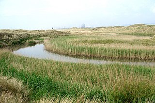
The South Wales Coast and Severn Estuary Coastal Path covers Region H of the larger Wales Coast Path, an 870-mile (1,400 km) long-distance walking route around the whole coast of Wales which opened on 5 May 2012. The South Wales Coast and Severn Estuary stretch is a 109-mile (176 km) in length running from Kenfig Dunes near Port Talbot, South Wales to Chepstow. With five local councils involved in its creation and maintenance, the route goes through a heritage coast, three national nature reserves and three heritage landscapes.