Adullam is an ancient ruin, formerly known by the Arabic appellation ʿAīd el Mâ, built upon a hilltop overlooking the Elah Valley, south of Bet Shemesh in Israel. In the late 19th century, the town was still in ruins. The hilltop ruin is also known by the name Khurbet esh-Sheikh Madkour, named after Madkour, one of the sons of the Sultan Beder, for whom is built a shrine (wely) and formerly called by its inhabitants Wely Madkour. The hilltop is mostly flat, with cisterns carved into the rock. The remains of stone structures which once stood there can still be seen. Sedimentary layers of ruins from the old Canaanite and Israelite eras, mostly potsherds, are noticeable everywhere, although olive groves now grow atop of this hill, enclosed within stone hedges. The villages of Aderet, Neve Michael/Roglit, and Aviezer are located nearby. Access to the site may be obtained by passing through the cooperative small holders' agricultural villages (Moshavim) of Aderet or Neve Michael. The ruin lies about 3 kilometers south of Moshav Neve Michael.

Kiryat Ata is a city in the Haifa District of Israel. Also still known by its former name of Kfar Ata, in 2017 it had a population of 57,518.
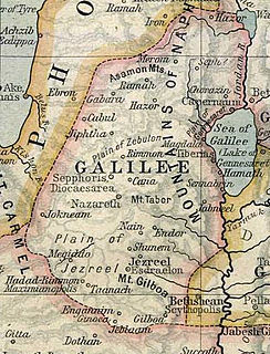
Endor was a Canaanite city which is listed in the Book of Joshua as one of the cities with its dependencies which the Israelites failed to dispossess. It was located between the Hill of Moreh and Mount Tabor in the Jezreel Valley.
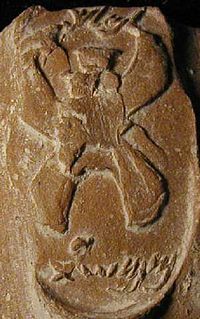
MMST appears exclusively on LMLK seal inscriptions, seen in archaeological findings in Israel, and its meaning has been the subject of continual controversy.
Ramat Rachel is a kibbutz in central Israel. An enclave within Jerusalem's municipal boundaries and overlooking Bethlehem and Rachel's Tomb, it falls under the jurisdiction of Mateh Yehuda Regional Council. In 2017 it had a population of 519.

The Large Stone Structure is the name given to the remains of a large public building in the City of David neighborhood of central Jerusalem, south of the Old City, tentatively dated to tenth to ninth century BC. The name was given to the structure by the discoverer of the site, Eilat Mazar, because of its proximity to another site known as the Stepped Stone Structure. Mazar, an Israeli archaeologist, announced the discovery on 4th August 2005, and stated that she believed it may be the remains of King David's palace as recorded in the Books of Samuel. The archaeological dig was funded privately by Roger Hertog, an American banker.
Kiryat Ye'arim, also known as Telz-Stone, is the site of an ultra-Orthodox town in the Jerusalem District of Israel. It is located in the approximate area of an ancient place mentioned in the Bible, from which it takes its name. It is bordered on one side by the Muslim Arab village of Abu Ghosh, and on the other side by the secular Jewish community of Neve Ilan. In 2017 it had a population of 4,840

Umm Tuba is an Arab neighborhood in East Jerusalem part of Sur Baher; it is northeast of Har Homa and Bethlehem, and southeast of Kibbutz Ramat Rachel. It has a population of 4,000. After the 1967 Six-Day War, Umm Tuba was incorporated into the municipal district of Jerusalem.
Nahal Tut is an archaeological site excavated along the streambed of the same name in northern Israel's Menashe Heights from February to July 2005 by Amir Gorzalczany and Gerald Finkielsztejn in preparation for the northward extension of Highway 6. Trig Point N-568 is situated south of Nahal Melah highway about halfway between modern Bat Shlomo and Yokneam.

Hamaam, or Wadi Hamam, is an Arab village near the Sea of Galilee and Mount Arbel in northern Israel. It is the easternmost part of the al-Batuf Regional Council. It contains one fairly modern mosque and the trail head for the steep ascent of Mount Arbel. In 2017 its population was 1,455.

Sokho, alternate spellings: Sokhoh, Sochoh, Soco, Sokoh, Hebrew: שוכה ,שוכו ,שכה, is the name given to two ancient towns in the territorial domain of Judah, the remains of both having been identified.
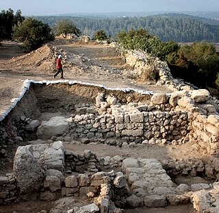
Khirbet Qeiyafa is the site of an ancient fortress city overlooking the Elah Valley and dated to the first half of the 10th century BCE. The ruins of the fortress were uncovered in 2007, near the Israeli city of Beit Shemesh, 30 km (20 mi) from Jerusalem. It covers nearly 2.5 ha and is encircled by a 700-meter-long (2,300 ft) city wall constructed of stones weighing up to eight tons each. Excavations at site continued in subsequent years. A number of archaeologists, mainly Yosef Garfinkel and Saar Ganor, have claimed that it might be the biblical city of Sha'arayim, because of the two gates discovered on the site, or Neta'im and that the large building at the center is an administrative building dating to the reign of King David, where he might have lodged at some point. This is based on their conclusions that the site dates to the early Iron IIA, ca. 1025–975 BCE, a range which includes the biblical date for the Kingdom of David. Others are sceptical, and suggest it might represent either a North Israelite, Philistine or Canaanite fortress. The techniques and interpretations used to reach the conclusion that Khirbet Qeiyafa was a fortress of King David have been criticised.

Khirbet Kefireh is a modern Palestinian village just north of Qatanna, West Bank on a hilltop covering about 4-5 acres. It appears in the Survey of Western Palestine map compiled in the 1870s, and most Bible dictionaries identify it with Chephirah.
Jaba' is a Palestinian village in the northern West Bank, located 8 kilometres (5.0 mi) southwest of the city of Jenin. According to the Palestinian Central Bureau of Statistics, the town had a population of 8,942 in the 2007 census. The village's name translates as "hill" and it is situated on the slopes of the Jabal Dabrun mountain. The village and its immediate vicinity contain a number of archaeological sites, including a tomb for a certain Neby Yarub. During the Ottoman era, Jaba' served as a throne village of the powerful Jarrar clan. The town is administered by a municipal council, currently headed by Bassam Jarrar.
Secacah is a town mentioned in the Hebrew Bible/Old Testament as well as in the Dead Sea Scrolls. The town was located in the wilderness of Judah, otherwise known as the Judean Desert, and is identified by some scholars with the archaeological site of Khirbet Qumran.
Khirbet Zanuta is a Palestinian village in the Hebron Governorate in the southern West Bank, located 20 kilometers south of Hebron. Nearby localities include ad-Dhahiriya to the northwest and Khirbet Shweika to the northwest, as well as two Israeli settlements, Teneh Omarim to the west and Shim'a to the east. The Meitarim industrial zone just to its east was built for the settlers. The village is adjacent to the Green Line.
Khirbet Qana is an archaeological site in the Lower Galilee of Israel. It has remains of a settlement from the Hellenistic to early Arab period. It has been associated with the Marriage at Cana of the New Testament.

Khirbet Beit Zakariyyah is a small Palestinian village in the West Bank. It is located in between the larger Israeli settlements of Alon Shevut and Rosh Tzurim in the Gush Etzion region. Administratively, it is associated with Artas, Bethlehem.

Khirbet et-Tibbâneh (Arabic: خربة التبانة), sometimes referred to by historical geographers as the Timnah of Judah, is a small ruin situated on a high ridge in the Judaean mountains, in the Sansan Nature Reserve, 622 metres (2,041 ft) above sea level, about 3 kilometers east of Aviezer and ca. 7 kilometers southeast of Bayt Nattif. The site is thought to have formerly borne the name Timnath, distinct from the Tel Batash-Timnah site associated with the biblical story of Samson in the lower foothills of Judea along the Sorek valley. Kh. et-Tibbaneh (Timnah) is perched upon a high mountain ridge rising up from the Elah valley and is where the episode of Judah and Tamar is thought to have taken place.