Khuzhir

Last updated

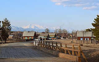
Khuzhir (Russian : Хужир) is the name of several rural localities in Russia:

Russian language East Slavic language

Russian is an East Slavic language, which is official in the Russian Federation, Belarus, Kazakhstan and Kyrgyzstan, as well as being widely used throughout Eastern Europe, the Baltic states, the Caucasus and Central Asia. It was the de facto language of the Soviet Union until its dissolution on 25 December 1991. Although nearly three decades have passed since the breakup of the Soviet Union, Russian is used in official capacity or in public life in all the post-Soviet nation-states, as well as in Israel and Mongolia.

The classification system of the types of inhabited localities in Russia, the former Soviet Union, and some other post-Soviet states has certain peculiarities compared with the classification systems in other countries.

Dzhidinsky District District in Republic of Buryatia, Russia

Dzhidinsky District is an administrative and municipal district (raion), one of the twenty-one in the Republic of Buryatia, Russia. It is located in the south of the republic. The area of the district is 8,600 square kilometers (3,300 sq mi). Its administrative center is the rural locality of Petropavlovka. As of the 2010 Census, the total population of the district was 29,352, with the population of Petropavlovka accounting for 25.4% of that number.

Okinsky District District in Republic of Buryatia, Russia

Okinsky District is an administrative and municipal district (raion), one of the twenty-one in the Republic of Buryatia, Russia. It is located in the west of the republic. The area of the district is 26,012 square kilometers (10,043 sq mi). Its administrative center is the rural locality of Orlik. As of the 2010 Census, the total population of the district was 5,353, with the population of Orlik accounting for 47.7% of that number.

Zakamensky District District in Republic of Buryatia, Russia

Zakamensky District is an administrative and municipal district (raion), one of the twenty-one in the Republic of Buryatia, Russia. It is located in the southwest of the republic. The area of the district is 15,320 square kilometers (5,920 sq mi). Its administrative center is the town of Zakamensk. As of the 2010 Census, the total population of the district was 28,453, with the population of Zakamensk accounting for 40.5% of that number.

Related Research Articles

Selsoviet is a shortened name for a rural council and for the area governed by such a council (soviet). The full names for the term are, in Belarusian: се́льскi Саве́т, Russian: се́льский Сове́т, Ukrainian: сільська́ ра́да. Selsoviets were the lowest level of administrative division in rural areas in the Soviet Union. After the dissolution of the Soviet Union, they were preserved as a third tier of administrative-territorial division throughout Ukraine, Belarus, and some of the federal subjects of Russia.

Soyot ethnic group

The Soyot people live mainly in the Oka region in the Okinsky District in the Republic of Buryatia, Russia. According to the 2010 census, there were 3,608 Soyots in Russia. Their extinct language was of a Turkic type and basically similar to the Tuvans. Their language has been reconstructed and a textbook has been published. The language is currently taught in some schools in Oka. The Oka River, the largest river flowing down from the Western Sayans into the Angara is called the Ok-hem meaning "an arrow-river" by the Soyots of the Oka River basin.

Nikolsk is the name of several inhabited localities in Russia.

Tayozhny/Tayezhny, Tayozhnaya/Tayezhnaya, or Tayozhnoye/Tayezhnoye is the name of several inhabited localities in Russia.

Bichursky District District in Republic of Buryatia, Russia

Bichursky District is an administrative and municipal district (raion), one of the twenty-one in the Republic of Buryatia, Russia. It is located in the south of the republic. The area of the district is 6,201 square kilometers (2,394 sq mi). Its administrative center is the rural locality of Bichura. As of the 2010 Census, the total population of the district was 25,352, with the population of Bichura accounting for 36.1% of that number.

Ivolginsky District District in Republic of Buryatia, Russia

Ivolginsky District is an administrative and municipal district (raion), one of the twenty-one in the Republic of Buryatia, Russia. It is located in the center of the republic. The area of the district is 2,660 square kilometers (1,030 sq mi). Its administrative center is the rural locality of Ivolginsk. As of the 2010 Census, the total population of the district was 37,983, with the population of Ivolginsk accounting for 19.4% of that number.

Khorinsky District District in Republic of Buryatia, Russia

Khorinsky District is an administrative and municipal district (raion), one of the twenty-one in the Republic of Buryatia, Russia. It is located in the center of the republic. The area of the district is 13,431 square kilometers (5,186 sq mi). Its administrative center is the rural locality of Khorinsk. As of the 2010 Census, the total population of the district was 18,467, with the population of Khorinsk accounting for 44.1% of that number.

Kizhinginsky District District in Republic of Buryatia, Russia

Kizhinginsky District is an administrative and municipal district (raion), one of the twenty-one in the Republic of Buryatia, Russia. It is located in the south of the republic. The area of the district is 7,871 square kilometers (3,039 sq mi). Its administrative center is the rural locality of Kizhinga. As of the 2010 Census, the total population of the district was 16,509, with the population of Kizhinga accounting for 38.6% of that number.

Kurumkansky District District in Republic of Buryatia, Russia

Kurumkansky District is an administrative and municipal district (raion), one of the twenty-one in the Republic of Buryatia, Russia. It is located in the northeast of the republic. The area of the district is 12,450 square kilometers (4,810 sq mi). Its administrative center is the rural locality of Kurumkan. As of the 2010 Census, the total population of the district was 15,007, with the population of Kurumkan accounting for 36.4% of that number.

Mukhorshibirsky District District in Republic of Buryatia, Russia

Mukhorshibirsky District is an administrative and municipal district (raion), one of the twenty-one in the Republic of Buryatia, Russia. It is located in the center of the republic. The area of the district is 4,539 square kilometers (1,753 sq mi). Its administrative center is the rural locality of Mukhorshibir. As of the 2010 Census, the total population of the district was 24,969, with the population of Mukhorshibir accounting for 20.9% of that number.

Selenginsky District District in Republic of Buryatia, Russia

Selenginsky District is an administrative and municipal district (raion), one of the twenty-one in the Republic of Buryatia, Russia. It is located in the center of the republic. The area of the district is 8,269 square kilometers (3,193 sq mi). Its administrative center is the town of Gusinoozyorsk. As of the 2010 Census, the total population of the district was 46,427, with the population of Gusinoozyorsk accounting for 52.9% of that number.

Yeravninsky District District in Republic of Buryatia, Russia

Yeravninsky District is an administrative and municipal district (raion), one of the twenty-one in the Republic of Buryatia, Russia. It is located in the east of the republic. The area of the district is 25,600 square kilometers (9,900 sq mi). Its administrative center is the rural locality of Sosnovo-Ozerskoye. As of the 2010 Census, the total population of the district was 18,705, with the population of Sosnovo-Ozerskoye accounting for 32.8% of that number.

Zaigrayevsky District District in Republic of Buryatia, Russia

Zaigrayevsky District is an administrative and municipal district (raion), one of the twenty-one in the Republic of Buryatia, Russia. It is located in the center of the republic. The area of the district is 6,605 square kilometers (2,550 sq mi). Its administrative center is the urban locality of Zaigrayevo. As of the 2010 Census, the total population of the district was 49,975, with the population of Zaigrayevo accounting for 11.2% of that number.

Orlik is the name of several rural localities in Russia:

Arshan is the name of several rural localities in Russia: