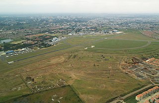
Wilson Airport is an airport in Nairobi, Kenya. It has flights to many regional airports in Kenya while Nairobi's main airport, Jomo Kenyatta International Airport, serves domestic and many international destinations.

Kenyatta University (KU) is a public research university with its main campus in both Nairobi County and Kiambu County, Kenya. It acquired the status of university in 1985, being the third university after University of Nairobi (1970) and Moi University (1984). As of October 2014, it was one of 23 public universities in the country.

Lang'ata is a suburb of Nairobi in Kenya. The suburb consists of many smaller housing developments, referred to as estates. They include Nairobi Dam, Otiende, Southlands, Ngei, Jambo estate, Onyonka, Madaraka Estate, Kutch Prant, Rubia and many others. These developments are primarily maisonettes or apartment blocks.

Kiambu County is a county in the former Central Province of Kenya. Its capital is Kiambu and its largest town is Thika. The county is adjacent to the northern border of Nairobi County and has a population of 1,623,282.
Its governor is Ferdinand Waititu.
The county is 40% rural and 60% urban owing to Nairobi's consistent growth Northwards. Kikuyu are the dominant tribe in the county.
Parklands, Nairobi, commonly referred to simply as Parklands, is a neighbourhood in the city of Nairobi, the capital and largest city in Kenya. It is divided into numbered avenues. The name arises from the proximity of the area to City Park, Nairobi.
Lavington is a suburb of Nairobi, Kenya. It is a high-income residential estate located northwest of the city centre. Lavington belongs to the Westlands administrative division of Nairobi. The bulk of the area now known as Lavington was originally the St Austin's Mission established by the French Holy Ghost Fathers.

Westlands, Nairobi is an affluent neighbourhood and administrative division in the city of Nairobi, the capital of and largest city in Kenya.
City High School is a school in Nairobi, Kenya.
South C is a middle-class residential estate located in the southland area of Nairobi.
Braeburn High School is a private international school located on Gitanga Road in the Lavington suburb of Nairobi, Kenya.
Kilimani is an affluent neighborhood in the city of Nairobi, the capital and largest city of Kenya. This administrative region belongs to Westlands.
Ngong Racecourse is a racecourse in Nairobi, Kenya. It is the main and currently only thoroughbred racing venue in Kenya. It is located along the Ngong Road near the Lenana School and next to The Nairobi Business Park, beside ngong forest. It is operated by the Jockey Club of Kenya.

Kenya Power and Lighting Company, commonly referred to as Kenya Power or KPLC, is a limited liability company which transmits, distributes and retails electricity to customers throughout Kenya.
Kahawa is a suburb settlement traversing the Kiambu County and Nairobi County borders along Thika Road. Despite its proximity to the city, most of its parts are administratively in Ruiru. Kenyatta University is found in this area. The current member of parliament for the area is Simon King'ara (2017-2022). The region is represented by Hon. Cyrus Omondi and Livingstone Wakibia Waiganjo (2017-2022).
Jamhuri High School, formerly known as Government Indian School and later The Duke of Gloucester School, is one of the oldest schools in Kenya. It was founded as a Railway Educational Centre in 1906. Prior to Kenya's independence from the British, the school, located at Ngara Nairobi, predominantly enrolled students from the Indian community in Nairobi, hence its former name Government Indian School.

Kasarani is a residential area in Nairobi, the capital city of Kenya.

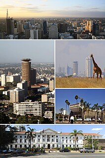
Nairobi County is one of the 47 counties of Kenya. The smallest yet most populous of the counties, it is coterminous with the city of Nairobi, which is also the capital and largest city of Kenya.
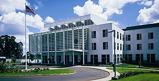
The Embassy of the United States of America to Kenya, located in Nairobi, is home to the diplomatic mission of the United States to the Republic of Kenya. The embassy opened in central Nairobi on 2 March 1964, when the United States established diplomatic relations with Kenya. In 1998, the original embassy was the target of a terrorist attack, after which a new embassy building was constructed in Gigiri, a suburb of Nairobi, in 2003. The US diplomatic mission to Somalia is also based at the Nairobi embassy.

United States International University Africa, also known as USIU Africa, is a private university in Kenya, the largest economy in the East African Community. The university is accredited by the Commission for Higher Education (CHE) in Kenya and by the Western Association of Schools and Colleges (WASC).