The MAX Blue Line is a light rail line serving the Portland metropolitan area in the U.S. state of Oregon. Operated by TriMet as part of the MAX Light Rail system, it connects Hillsboro, Beaverton, Portland, and Gresham. The Blue Line is the longest in the network; it travels approximately 33 miles (53 km) and serves 48 stations from Hatfield Government Center to Cleveland Avenue. It is the busiest of the five MAX lines, having carried an average 55,370 riders each day on weekdays in September 2018. Service runs for 221⁄2 hours per day from Monday to Thursday, with headways of between 30 minutes off-peak and five minutes during rush hour. It runs later in the evening on Fridays and Saturdays and ends earlier on Sundays.

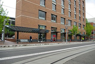
Old Town/Chinatown station is a MAX Light Rail station served by the Blue and Red Lines. It is located in the Old Town Chinatown neighborhood in Portland, Oregon and is currently the 6th stop eastbound on the Eastside MAX. It is also the last stop before crossing the Willamette River. It is next to the Portland Downtown Heliport. The station was previously also served by the Yellow Line, from 2004 to 2009, until that line's relocation to the Portland Transit Mall.

Yamhill District and Morrison/Southwest 3rd Avenue are light rail stations on the MAX Blue and Red Lines in downtown Portland, Oregon. Located in the Yamhill Historic District, it is the 3rd stop eastbound on the current Eastside MAX. It was also the eastern terminus of the transit mall. It originally served the Yellow Line from 2004 to 2009 until its relocation to the Portland Transit Mall.

Mall/Southwest 4th Avenue and Mall/Southwest 5th Avenue were a pair of light rail stations in Portland, Oregon, United States, served by TriMet as part of the MAX Light Rail system. Built into the sidewalk at Southwest Yamhill and Morrison streets between 4th and 5th avenues in downtown Portland, the Mall stations were served by the Blue and Red lines upon closing. They had also been served by the Yellow Line from May 2004 to August 2009.
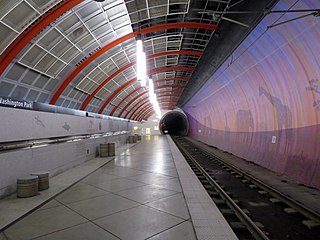
Washington Park is a light rail station in Portland, Oregon, United States, served by TriMet as part of the MAX Light Rail system. Situated between Sunset Transit Center and Goose Hollow/Southwest Jefferson Street station, it is the 17th and 3rd station eastbound on the Blue Line and the Red Line, respectively. The station's two tracks and island platform are part of the Robertson Tunnel beneath Portland's West Hills. Its head house and surface-level plaza occupy the middle of a parking lot surrounded by the Hoyt Arboretum, Oregon Vietnam Veterans Memorial, Oregon Zoo, and World Forestry Center. Washington Park is the only completely underground station in the MAX system. At 260 feet (79 m) below ground, it is the deepest transit station in North America and in the western hemisphere. It is also the seventh-deepest in the world.

Goose Hollow/Southwest Jefferson Street is a light rail station on the MAX Blue and Red Lines in the Goose Hollow neighborhood of Portland, Oregon. It is the third stop westbound on the Westside MAX alignment and makes several cameo appearances in the movie What the Bleep Do We Know!? as the stop where Marlee Matlin's character boards the train to get into town.

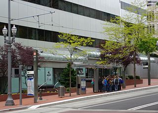
Library/Southwest 9th Avenue and Galleria/Southwest 10th Avenue are light rail stops on the MAX Blue and Red Lines in Portland, Oregon. It was the original western terminus and is now the Eastside MAX line's first stop eastbound/last stop westbound in downtown.

Pioneer Square South and Pioneer Square North are a pair of light rail stations in Portland, Oregon, United States, served by TriMet as part of the MAX Light Rail system. Situated directly west of the Portland Transit Mall at Pioneer Courthouse Square in downtown Portland, they occupy the sidewalk on Yamhill and Morrison streets between Broadway and 6th Avenue. The stations consist of one side platform each; trains traveling eastbound stop at Pioneer Square South while trains traveling westbound stop at Pioneer Square North.

Like transportation in the rest of the United States, the primary mode of local transportation in Portland, Oregon is the automobile. Metro, the metropolitan area's regional government, has a regional master plan in which transit-oriented development plays a major role. This approach, part of the new urbanism, promotes mixed-use and high-density development around light rail stops and transit centers, and the investment of the metropolitan area's share of federal tax dollars into multiple modes of transportation. In the United States, this focus is atypical in an era when automobile use led many areas to neglect their core cities in favor of development along interstate highways, in suburbs, and satellite cities.
Portland is "an international pioneer in transit orientated developments."

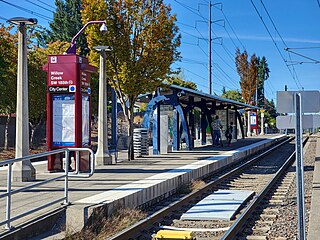
Elmonica/Southwest 170th Avenue is a light rail station on the MAX Blue and Red lines in Beaverton, Oregon, United States. Named after a former station on the Oregon Electric Railway, it is the eleventh stop westbound on the Westside MAX. The side platform stop is located between Hillsboro to the west and Beaverton to the east.
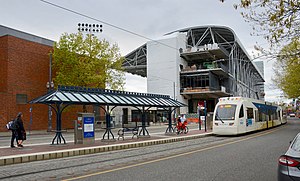
Willow Creek/Southwest 185th Avenue Transit Center is a multimodal transport hub in Hillsboro, Oregon, United States. Owned and operated by TriMet, it is served by bus and light rail. The transit center is the ninth station eastbound on the Blue Line, the fifth station eastbound on the Red Line, and a hub for bus routes mostly serving Washington County in the Portland metropolitan area. It is located by the intersection of Southwest Baseline Road and 185th Avenue near the city's boundary with Beaverton.
Goose Hollow is a neighborhood in southwest Portland, Oregon. It acquired its distinctive name through early residents' practice of letting their geese run free in Tanner Creek Gulch and near the wooded ravine in the Tualatin Mountains known as the Tanner Creek Canyon. Tanner Creek Gulch was a 20-block-long, 50-foot-deep (15 m) gulch that started around SW 17th and Jefferson and carried the waters of Tanner Creek into Couch Lake. Over a century ago, Tanner Creek was buried 50 feet (15 m) underground, and the Tanner Creek Gulch was filled in. The only remaining part of the hollow is the ravine, Tanner Creek Canyon, carved out by Tanner Creek through which The Sunset Highway carrying US-26 passes and which the Vista Bridge spans, also called the Vista Viaduct.

The Vista Bridge is an arch bridge for vehicles and pedestrians located in Portland, Oregon, United States. It connects the areas of King's Hill and Vista Ridge which are both in the Goose Hollow neighborhood. The MAX Light Rail line and Jefferson Street/Canyon Road travel under the bridge, and Vista Avenue crosses the bridge.

The Robertson Tunnel is a twin-bore light rail tunnel through the Tualatin Mountains west of Portland, Oregon, United States, used by the MAX Blue and Red Lines. The tunnel is 2.9 miles long and consists of twin 21-foot-diameter (6.4 m) tunnels. There is one station within the tunnel at Washington Park, which at 259 feet (79 m) deep is the deepest subway station in the United States and the fifth-deepest in the world. Trains are in the tunnel for about 5 minutes, which includes a stop at the Washington Park station. The tunnel has won several worldwide engineering and environmental awards. It was placed into service September 12, 1998.

Southwest 6th & Pine and Southwest 5th & Oak stations are a pair of light rail stations on the MAX Green, Orange and Yellow Lines in Portland, Oregon. It is the 3rd stop southbound on the Portland Transit Mall extension.

Pioneer Courthouse/Southwest 6th and Pioneer Place/Southwest 5th stations are a pair of light rail stations on the MAX Green, Orange and Yellow Lines in Portland, Oregon. They are the 4th stop southbound on the Portland Transit Mall MAX extension. The Pioneer Courthouse/Southwest 6th station is served only by the Green and Yellow Lines, and the Pioneer Place/Southwest 5th station is served only by the Green and Orange Lines. Originally, from the opening of these stations in 2009 until 2015, the Yellow Line served both, but in September 2015 the then-new Orange Line replaced the Yellow Line at all southbound stations on the transit mall.
Southwest 6th & Madison Street and City Hall/Southwest 5th & Jefferson Street stations are a pair of light rail stations on the MAX Green, Orange and Yellow Lines in Portland, Oregon. It is the fifth stop southbound on the Portland Transit Mall extension.
The PSU Urban Center stations are light rail stations on the MAX Green, Orange and Yellow Lines in downtown Portland, Oregon, United States, located adjacent to the PSU Urban Center, of Portland State University. The northbound platform is the PSU Urban Center/Southwest 6th & Montgomery station, and the southbound platform is the PSU Urban Center/Southwest 5th & Mill station. The stations opened on August 30, 2009, and for the next three years they were temporarily the southern passenger terminus of the Portland Transit Mall MAX extension, awaiting construction of the PSU South stations. The latter opened on September 2, 2012, and the change made PSU Urban Center the second stop northbound and the next-to-last stop southbound on the Portland Mall MAX lines.
Providence Park is a light rail station on the MAX Blue and Red lines located in the Goose Hollow neighborhood of Portland, Oregon. It is named after the adjacent stadium, Providence Park. The station primarily serves Providence Park and residential areas around West Burnside Street. The station, consisting of separate eastbound and westbound platforms built into city sidewalks between SW 17th and SW 18th Avenues on SW Yamhill and SW Morrison Streets, opened on August 31, 1997.

King's Hill Historic District, located in southwest Portland, Oregon, is listed on the National Register of Historic Places.