
Yukon is the smallest and westernmost of Canada's three territories. It also is the least populated province or territory in Canada, with a population of 35,874 people as of the 2016 Census. Whitehorse, the territorial capital and Yukon's only city, is the largest settlement in any of the three territories.

Tutchone is an Athabaskan language spoken by the Northern and Southern Tutchone First Nations in central and southern regions of Yukon Territory, Canada. Tutchone belongs to the Northern Athabaskan linguistic subfamily and has two primary varieties, Southern and Northern. Although they are sometimes considered separate languages, Northern and Southern Tutchone speakers are generally able to understand each other in conversation, albeit with moderate difficulty.

Kluane National Park and Reserve are two protected areas in the southwest corner of the territory of Yukon. The National Park Reserve was set aside in 1972 to become a national park, pending settlement of Native American land claims. It covered an area of 22,013 square kilometres. When agreement was reached with the Champagne and Aishihik First Nations over an eastern portion of the Reserve, that part—about 5,900 square kilometres —became a national park in 1993, and is a unit of the national park system administered co-operatively with Parks Canada. The larger western section remains a Reserve, awaiting a final land claim settlement with the Kluane First Nation. The park borders B.C. to the south, while the Reserve borders both B.C. to the south, and the United States (Alaska) to the south and west.
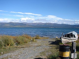
Burwash Landing is a small community, at historical mile 1093 on the Alaska Highway, in Yukon, Canada along the southern shore of Kluane Lake.

Yukon is in the northwestern corner of Canada and is bordered by Alaska and the Northwest Territories. The sparsely populated territory abounds with natural scenic beauty, with snowmelt lakes and perennial white-capped mountains, including many of Canada's highest mountains. The territory's climate is Arctic in the north, subarctic in the central region, between north of Whitehorse and Old Crow, and has a humid continental climate in the far south, south of Whitehorse and in areas close to the British Columbia border. The long sunshine hours in the short summer allow a profusion of flowers and fruit to blossom. Most of the territory is boreal forest, tundra being the main vegetation zone only in the extreme north and at high elevations.

Tatshenshini-Alsek Park or Tatshenshini-Alsek Provincial Wilderness Park is a provincial park in British Columbia, Canada 9,580 km2 (3,700 sq mi). It was established in 1993 after an intensive campaign by Canadian and American conservation organizations to halt mining exploration and development in the area, and protect the area for its strong natural heritage and biodiversity values.

Kluane Lake is located in the southwest area of the Yukon. It is the largest lake contained entirely within Yukon at approximately 408 km2 (158 sq mi), and 81 km (50 mi) long.
The Kluane First Nation (KFN) is a First Nations band government in Yukon, Canada. Its main centre is in Burwash Landing, Yukon along the Alaska Highway on the shores of Kluane Lake, the territory's largest lake. The native language spoken by the people of this First Nation is Southern Tutchone. They call themselves after the great Lake Lù’àn Män Ku Dän or Lù’àn Mun Ku Dän.
The White River First Nation (WRFN) is a First Nation of Upper Tanana, Northern Tutchone, and Southern Tutchone peoples in the western Yukon Territory in Canada. Its main population centre is Beaver Creek, Yukon.

The Southern Tutchone are a First Nations people of the Athabaskan-speaking ethnolinguistic group living mainly in the southern Yukon in Canada. The Southern Tutchone language, traditionally spoken by the Southern Tutchone people, is a variety of the Tutchone language, part of the Athabaskan language family. Some linguists suggest that Northern and Southern Tutchone are distinct and separate languages.
Southern Lakes was an electoral district in rural Yukon which returned a member to the Legislative Assembly of the Yukon in Canada. It was one of the eight rural ridings in the Yukon at the time.

Lake Laberge is an electoral district which returns a member to the Legislative Assembly of the Yukon Territory in Canada. It is one of the Yukon's eight rural districts and is named after the eponymous Lake Laberge, which is within the riding.
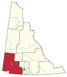
Kluane is an electoral district which returns a member to the Legislative Assembly of the Canadian territory of Yukon. It is named after Kluane National Park, which is within the riding. It is one of the Yukon's eight rural districts.
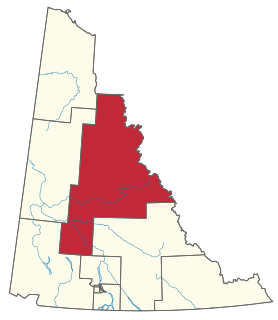
Mayo-Tatchun is an electoral district which returns an MLA to the Legislative Assembly of the Yukon Territory in Canada. It is an amalgamation of the former Mayo and Tatchun electoral districts.
Aishihik Lake is a lake in southwestern Yukon, Canada. Yukon Electric Corporation operates a 37 megawatt hydroelectric dam at the south end of the lake, where it drains southward into the Aishihik River.
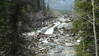
Kusawa Lake is a lake in the southern Yukon, Canada. Kusawa means "long narrow lake" in the Tlingit language. The Kusawa Lake is a lake in Canada's Yukon Territory. It is located at an altitude of 671 m (2,201 ft) and is 60 km (37 mi) southwest of Whitehorse near the British Columbia border. It meanders over a length of 75 km (47 mi) with a maximum width of about 2.5 km (1.6 mi) through the mountains in the north of the Boundary Ranges. It is fed by the Primrose River and Kusawa River. The Takhini outflows to the Yukon River from the northern tip of Kusawa Lake. Kusawa Lake has an area of 142 km2 (55 sq mi). The lake has a maximum depth of 140 m (460 ft) and is of glacial origin. It is a common tourist destination and is also popular for fishing.
Wade Istchenko is a Canadian politician, who was elected to in the Yukon Legislative Assembly in the 2011 and 2016 elections. A former Cabinet minister, he currently represents the rural Yukon district of Kluane as a member of the opposition Yukon Party caucus.
The Yukon Ice Patches are a series of dozens of ice patches in the southern Yukon discovered in 1997, which have preserved hundreds of archaeological artifacts, with some more than 9,000 years old. The first ice patch was discovered on the mountain Thandlät, west of the Kusawa Lake campground which is 60 km (37 mi) west of Whitehorse, Yukon. The Yukon Ice Patch Project began shortly afterwards with a partnership between archaeologists in partnership with six Yukon First Nations, on whose traditional territory the ice patches were found. They include the Carcross/Tagish First Nation, the Kwanlin Dün First Nation, the Ta’an Kwäch’än Council, the Champagne and Aishihik First Nations, the Kluane First Nation, and the Teslin Tlingit Council.
Diyet van Lieshout is a Canadian singer-songwriter from the Yukon, who has recorded and performed both as a solo artist and with the band Diyet and the Love Soldiers. She is most noted as a Canadian Folk Music Award winner for Indigenous Songwriter of the Year at the 15th Canadian Folk Music Awards.