
The Pigeon River forms part of the Canada–United States border between the state of Minnesota and the province of Ontario, west of Lake Superior. In pre-industrial times the river was a waterway of great importance for transportation and the fur trade.

The Rainy River is a river, approximately 137 kilometres (85 mi) long, which forms part of the Canada–United States border separating northern Minnesota and Northwestern Ontario.

The Boundary Waters, also called the Quetico-Superior country, is a region of wilderness straddling the Canada–United States border between Ontario and Minnesota, in the region just west of Lake Superior. This region is part of the Superior National Forest in northeastern Minnesota, and in Canada it includes La Verendrye and Quetico Provincial Parks in Ontario. Voyageurs National Park in Minnesota may also be considered part of the Boundary Waters. The name "Boundary Waters" is often used in the U.S. to refer specifically to the U.S. Wilderness Area protecting its southern extent, the Boundary Waters Canoe Area Wilderness.
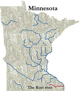
The Root River flows for 80 miles (130 km) through the Driftless Area of southeastern Minnesota and is a tributary of the Upper Mississippi River. It is an excellent river for canoeing. The gentle to moderate flowing river drops an average of 3.4 ft/mile from Chatfield, Minnesota, to its pour point in the Mississippi River into Navigation Pool 7 just south of La Crosse, Wisconsin.
The Baudette River is a short tributary of the Rainy River in northern Minnesota in the United States. Via the Rainy River, Lake of the Woods, the Winnipeg River, Lake Winnipeg and the Nelson River, it is part of the Hudson Bay watershed. It drains a flat region which was a prehistoric lake bed of glacial Lake Agassiz.
The Pine River flows along the Minnesota-Ontario border a short distance, primarily within the Boundary Waters Canoe Area Wilderness and La Verendrye Provincial Park. From Gunflint Lake, the river flows north into Magnetic Lake and from there into Clove Lake and finally Granite Lake where it joins the Granite River. The Granite River then continues northward along the border into Saganaga Lake.
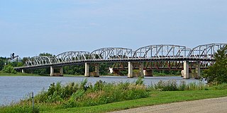
The Baudette – Rainy River International Bridge is an international bridge connecting Rainy River, Ontario, Canada, with Baudette, Minnesota, United States, across the Rainy River.
Eva Marion Lake was a local services board in the Canadian province of Ontario, consisting of much of the portion of the Rainy River District lying east of Atikokan, including the communities of Sapawe and Kawene.
The Basswood River is a river that forms part of the Canada–United States border between Minnesota and Ontario.
The Beartrap River is a river of Minnesota.
The Bottle River is a river that forms part of the Canada–United States border between Minnesota and Ontario.
The Horse River is a river of Minnesota.
The Island River is a river of Minnesota.
The Knife River is a 23.9-mile-long (38.5 km) river of northern Minnesota which drains a portion of Lake and Saint Louis counties into Lake Superior between Duluth and Two Harbors.
The Little Knife River (East) is a 5.7-mile-long (9.2 km) river in Lake County, Minnesota, United States. It is a tributary of the Knife River, located northwest of the city of Two Harbors. A second Little Knife River flows into the Knife River from the west, through St. Louis County.
The Little Knife River (West) is a 7.4-mile-long (11.9 km) river in St. Louis County, Minnesota, United States. It is a tributary of the Knife River. A second Little Knife River flows into the Knife River from the east, in Lake County.
The Loon River is a river that forms part of the Canada–United States border between Minnesota and Ontario.
The Range River is a river of Minnesota.
The Shagawa River is a river of Minnesota. The river flows through the east–central part of Morse Township in northern Saint Louis County.
Crooked Lake is a lake that straddles the border of the state of Minnesota in the United States and the province of Ontario in Canada. It is part of the Basswood River, and extends from Lower Basswood Falls to Curtain Falls. The U.S. portion of the lake is located in Saint Louis County, within the Boundary Waters Canoe Area Wilderness in the Superior National Forest; the Canadian waters are part of Quetico Provincial Park.


