Related Research Articles

Clay County is a county located in the U.S. state of Arkansas. Originally incorporated as Clayton County, as of the 2020 census, its population was 14,552. The county has two county seats, Corning and Piggott. It is a dry county, in which the sale of alcoholic beverages is restricted or prohibited.

Barry County is a county located in the southwest portion of the U.S. state of Missouri. As of the 2020 Census, the population was 34,534. Its county seat is Cassville. The county was organized in 1835 and named after William Taylor Barry, a U.S. Postmaster General from Kentucky. The town of Barry, also named after the postmaster-general, was located just north of Kansas City, not in Barry County.

White County is a county located in the U.S. state of Arkansas. As of the 2020 census, the population was 76,822. The county seat is Searcy. White County is Arkansas's 31st county, formed on October 23, 1835, from portions of Independence, Jackson, and Pulaski counties and named for Hugh Lawson White, a Whig candidate for President of the United States. It is an alcohol prohibition or dry county, though a few private establishments can serve alcohol.

Bald Knob is a city in White County, Arkansas, United States. The population was 2,897 at the 2010 census. Located at the intersection of two of the state's natural regions, Bald Knob is often promoted as "where the Ozarks meet the Delta". Bald Knob is known for its yearly Home Fest held during Mother's Day weekend. It was once known as the leading strawberry producer in the world in the 1950s. Bald Knob was established in 1881.
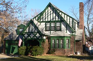
The Country Club Historic District is located in Omaha, Nebraska from 50th to 56th Streets and from Corby to Seward Streets. It includes dozens of homes built between 1925 and 1949 in the late 19th and 20th Century Revival styles. It was added to the National Register of Historic Places in 2004.
Knob Noster State Park is a public recreation area covering 3,934 acres (1,592 ha) in Johnson County, Missouri, in the United States. The state park bears the name of the nearby town of Knob Noster, which itself is named for one of two small hills or "knobs" that rise up in an otherwise flat section of Missouri. Noster is a Latin adjective meaning "our"—therefore, Knob Noster translates as "our hill." A local Indian belief stated that the hills were "raised up as monuments to slain warriors." The park offers year-round camping, hiking, and fishing and is managed by the Missouri Department of Natural Resources.
Fort Hovey was a small Civil War era earth-and-wood fort built on a hill overlooking the junction of the road running south out of Ironton, Missouri and the road running east to Fredericktown, Missouri. Fort Hovey was intended to help protect the Arcadia Valley and the iron mines located on Pilot Knob. The fort was located on Fort Hill near the town of Arcadia, Missouri on the (then) property of the Fort Hill Methodist Episcopal Church, South and the present day Arcadia Valley United Presbyterian Church. This fortification was named Fort Hovey in honor of the commander of the 33rd Illinois Volunteer Infantry Regiment (Union), Colonel Charles E. Hovey. The 33rd. Illinois was stationed there during the Autumn and Winter of 1861-62, at which time they built the fort.
Bruno is an unincorporated community in Marion County, Arkansas, United States. It is the location of five places listed on the National Register of Historic Places:
Buford is an unincorporated community in Baxter County, Arkansas, United States. It is the location of Buford School Building, which is located on AR 126 and is listed on the National Register of Historic Places.

Brightwater is a community in Benton County, Arkansas, United States. It is the location of Springfield to the Fayetteville Road-Brightwater Segment, which is located at N Old Wire Road/Benton Cty Rd. 67, south of US 62 and is listed on the National Register of Historic Places.

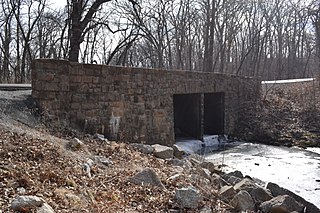
Cherokee City is an unincorporated census-designated place (CDP) in Benton County, Arkansas, United States. Per the 2020 census, the population was 73. It is the location of Coon Creek Bridge, which is located on Cty Rd. 24 and is listed on the National Register of Historic Places. The community was named for the Cherokee, since the Trail of Tears crossed the landscape when the Cherokee migrated west to Indian territory, now Oklahoma in the late 1830s. The town is within the Northwest Arkansas region, located about 5 miles east of Oklahoma and 4 miles south of the Missouri state line.
Colville is an unincorporated community in Benton County, Arkansas, United States. It is the location of Mt. Hebron M.E. Church South and Cemetery, which is located at 1079 Mt. Hebron Road and is listed on the National Register of Historic Places.
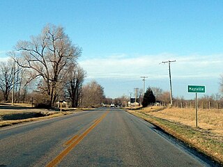
Maysville is an unincorporated community and census-designated place (CDP) in Benton County, Arkansas, United States. It is the westernmost settlement in the state of Arkansas. Per the 2020 census, the population was 117. It is located in the Northwest Arkansas region.
Osage Mills is an unincorporated community in Benton County, Arkansas, United States. The millsite and associated dam is located on Little Osage Creek about eight miles southwest of Rogers. It is the location of the following places listed on the National Register of Historic Places on January 28, 1988:
Self is an unincorporated community in Boone County, Arkansas, United States. It is the location of Cottonwood School No. 45, which is located at Cottonwood and Dubuque Roads and is listed on the National Register of Historic Places.
Pedro is an unincorporated community in Benton County, Arkansas, United States.

War Eagle is an unincorporated community in Benton County, Arkansas, United States. It is the location of War Eagle Bridge, which carries CR 98 over War Eagle Creek and is listed on the National Register of Historic Places.

The Knob School, also called the Masonic Lodge, is a historic school and Masonic lodge building on Arkansas Highway 141 in Knob, Arkansas. It is a two-story wood-frame structure with a hip roof, and a single-story extension to the front with a hip roof and a recessed porch. The building has vernacular Craftsman style, with extended eaves supported by exposed brackets. It was built in 1923 to serve the dual purpose of providing the community with school facilities and space for Masonic lodge meetings.

St. Richard's Catholic Church is a historic church at the junction of Hickory and Cleveland Streets in Bald Knob, Arkansas. It is attended by St. James Church, Searcy, in the Diocese of Little Rock.
Estes Wilson Mann Sr. was an American architect based in Memphis, Tennessee. Several buildings he designed are listed on the National Register of Historic Places.
References
36°16′53″N90°26′53″W / 36.28139°N 90.44806°W
| | This article about a location in Clay County, Arkansas is a stub. You can help Wikipedia by expanding it. |