| Look up Kreuzberg in Wiktionary, the free dictionary. |
Kreuzberg is a German word that means "cross mountain" and may refer to:
| Look up Kreuzberg in Wiktionary, the free dictionary. |
Kreuzberg is a German word that means "cross mountain" and may refer to:
| This disambiguation page lists articles associated with the title Kreuzberg. If an internal link led you here, you may wish to change the link to point directly to the intended article. |

Kreuzberg, is a district of Berlin, Germany. It is part of the Friedrichshain-Kreuzberg borough located south of Mitte. During the Cold War era, it was one of the poorest areas of West Berlin, but since German reunification in 1990 it has become more gentrified and known for its arts scene.

Mitte is the first and most central borough of Berlin. The borough consists of six sub-entities: Mitte proper, Gesundbrunnen, Hansaviertel, Moabit, Tiergarten and Wedding.

Friedrichshain-Kreuzberg is the second borough of Berlin, formed in 2001 by merging the former East Berlin borough of Friedrichshain and the former West Berlin borough of Kreuzberg. The historic Oberbaum Bridge, formerly a Berlin border crossing for pedestrians, links both districts across the river Spree as the new borough's landmark.

Pankow is the most populous and the second-largest borough of Berlin. In Berlin's 2001 administrative reform it was merged with the former boroughs of Prenzlauer Berg and Weißensee; the resulting borough retained the name Pankow. Pankow was sometimes claimed by the Western Allies to be the capital of the German Democratic Republic, while the German Democratic Republic itself considered East Berlin to be its capital.

The Rhön Mountains are a group of low mountains in central Germany, located around the border area where the states of Hesse, Bavaria and Thuringia come together. These mountains, which are at the extreme southeast end of the East Hesse Highlands, are partly a result of ancient volcanic activity. They are separated from the Vogelsberg Mountains by the river Fulda and its valley. The highest mountain in the Rhön is the Wasserkuppe which is in Hesse. The Rhön Mountains are a popular tourist destination and walking area.

Friedrichshain is a district of the Friedrichshain-Kreuzberg borough in Berlin, Germany. From its creation in 1920 until 2001, it was a freestanding city borough. Formerly part of East Berlin, it is adjacent to Mitte, Prenzlauer Berg, Kreuzberg and Lichtenberg.

The Oberbaum Bridge is a double-deck bridge crossing Berlin's River Spree, considered one of the city's landmarks. It links Friedrichshain and Kreuzberg, former boroughs that were divided by the Berlin Wall, and has become an important symbol of Berlin’s unity.
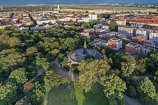
The Viktoriapark is an urban park in the locality of Kreuzberg in Berlin, Germany. It opened in 1894.
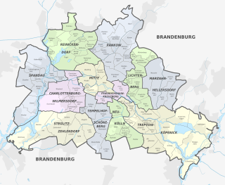
Berlin is both a city and one of Germany’s federal states. Since the 2001 administrative reform, it has been made up of twelve boroughs or districts, each with its own local government, though all boroughs are subject to Berlin’s city and state government.
Neukölln, until 1920 an independent city, is an inner-city district of Berlin in the homonymous borough (Bezirk) of Neukölln, including the historic village of Alt-Rixdorf and numerous Gründerzeit apartment blocks. With 166,714 inhabitants (2018) the Ortsteil is the most densely populated of Berlin. It was originally characterized by mostly working-class inhabitants and later a relatively high percentage of immigrants, especially of Turkish and Russian descent, but since the turn of the millennium an influx of students, creatives, and western immigrants has led to gentrification.

Berlin Friedrichshain-Kreuzberg- - Prenzlauer Berg East is one of the 299 single member constituencies used for the German parliament, the Bundestag. Located east of Berlin centre, it was created for the 2002 election and is the only single member constituency in the Bundestag to be represented by Alliance '90/The Greens (GR). As of the 2017 election, the district is represented by Canan Bayram.
Alt-Treptow is a German locality in the borough of Treptow-Köpenick in Berlin. Known also as Treptow it was, until 2001, the main and the eponymous locality of the former Treptow borough.
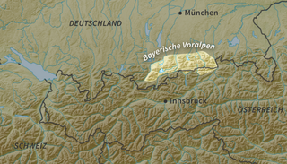
The Bavarian Prealps are a mountain range within the Northern Limestone Alps in south Germany. They include the Bavarian Prealp region between the river Loisach to the west and the river Inn to the east; the range is about 80 kilometres (50 mi) long and 20–30 kilometres (12–19 mi) wide. The term is not defined politically, but alpine-geographically because small areas of the Bavarian Prealps lie in Tyrol.

Plänterwald is a German locality (Ortsteil) within the Berlin borough (Bezirk) of Treptow-Köpenick. Until 2001 it was part of the former borough of Treptow and the site of its former town hall.

The Prussian National Monument for the Liberation Wars is a war memorial in Berlin, Germany, dedicated in 1821. Built by the Prussian king during the sectionalism before the Unification of Germany it is the principal German monument to the Prussian soldiers and other citizens who died in or else dedicated their health and wealth for the Liberation Wars (Befreiungskriege) fought at the end of the Wars of the Sixth and in that of the Seventh Coalition against France in the course of the Napoleonic Wars. Frederick William III of Prussia initiated its construction and commissioned the Prussian Karl Friedrich Schinkel who made it an important piece of art in cast iron, his last piece of Romantic Neo-Gothic architecture and an expression of the post-Napoleonic poverty and material sobriety in the liberated countries.
The Kreuzberg is a hill in the Kreuzberg locality of Berlin, Germany, in former West Berlin. It rises about 66 m (217 ft) above the sea level. It was named by King Frederick William III of Prussia after the Iron Cross which crowns the top of the Prussian National Monument for the Liberation Wars, designed by Karl Friedrich Schinkel, on its inauguration on 30 March 1821. On 27 September 1921 the borough assembly of the VIth borough of Berlin decided to name the borough after the hill. The borough was subsequently downgraded to a locality in 2001,

The Mehringdamm is a street in southern Kreuzberg, Berlin. In the north it starts at Mehringbrücke and ends - with its southern most houses already belonging to Tempelhof locality - on Platz der Luftbrücke. It is the historical southbound Berlin-Halle highway, now forming the federal route 96. The main junction of Mehringdamm is with the 19th-century ring road around Berlin's inner city, named Yorckstraße west, and Gneisenaustraße east of Mehringdamm.

The Black Mountains are part of the High Rhön in Germany, in particular of the Southern High Rhön, which lies south of the Kreuzberg Group and is thus the southernmost part of the High Rhön. Since 1993, most of the region has been protected by the Black Mountain Nature Reserve, the second largest in Bavaria outside of the Alps, in order to counteract its afforestation by coniferous forest.