Kundar River

Last updated
Indus river.svg

Kundar River is located in Balochistan, Pakistan. [1] Formed by the meltwater from the Sulaiman Mountains, the Kundar is a tributary of Gomal River. The Kundar is one of the two principal drainage channels of Zhob District, the other channel being Zhob River. Both the Zhob and Kundar flow into the Gomal. [2]

Related Research Articles

<span class="mw-page-title-main">Sulaiman Mountains</span> Mountain range in Afghanistan and Pakistan

The Sulaiman Mountains, also known as Kōh-e Sulaymān or Da Kasē Ghrūna, are a north–south extension of the southern Hindu Kush mountain system in Pakistan and Afghanistan. They rise to form the eastern edge of the Iranian plateau. They are located in the Kandahar, Zabul and Paktia provinces of Afghanistan, and in Pakistan they extend over the northern part of Balochistan and Waziristan as well as Kurram of Khyber Pakhtunkhwa. In southwestern Punjab, the mountains extend into the two districts of Dera Ghazi Khan and Rajanpur, which are located west of the Indus River on the boundary with Balochistan. Bordering the mountains to the east are the plains of the Indus River valley, and to the north are the arid highlands of the Central Hindu Kush whose heights extend up to 3,383 metres (11,099 ft). The total area on which this range spans around 6475 sq. km .Together with the Kirthar Mountains on the border between Balochistan and Sindh, the Sulaiman Mountains form what is known as the Sulaiman-Kirthar geologic province.

<span class="mw-page-title-main">Dera Ismail Khan</span> City in Khyber Pakhtunkhwa, Pakistan

Dera Ismail Khan, abbreviated as D.I. Khan, is a city and capital of Dera Ismail Khan District, located in Khyber Pakhtunkhwa, Pakistan. It is the 37th largest city of Pakistan and fifth largest in the province of Khyber Pakhtunkhwa by population. Dera Ismail Khan is situated on the west bank of the Indus River, at its junction with the Gomal River.

<span class="mw-page-title-main">Dera Ismail Khan District</span> District sub-division in Pakistan

Dera Ismail Khan District, often abbreviated as D.I. Khan is a district in the Dera Ismail Khan division of the Khyber Pakhtunkhwa province of Pakistan. The capital of the district is the town of Dera Ismail Khan. The district has an area of 9,334 km2 (3,604 sq mi) and a population of 1,627,132 as of the 2017 Census.

The Balkh River or Balkhab, also known in its upper reaches as the Band-e Amir River, is a river in northern Afghanistan.

<span class="mw-page-title-main">Zhob District</span> District of Balochistan in Pakistan

Zhob District is a district in the northwestern part of Balochistan province of Pakistan. The population of Zhob District was estimated at 310,544 in 2017. Water from Zhob River is used for irrigation in the district.

Gomal Pass is a mountain pass on the Durand Line border between Afghanistan and the southeastern portion of South Waziristan in Pakistan's Federally Administered Tribal Areas. It takes its name from the Gomal River and is midway between the legendary Khyber Pass and the Bolan Pass. It connects Ghazni in Afghanistan with Tank and Dera Ismail Khan in Pakistan. Gomal Pass, for a long time, has been a trading route for nomadic Powindahs.

The Storyani, also called Ustrani or Ustarana, are a Pashtun tribe of Sayyid origin inhabiting the Frontier Region in the outer hills opposite the extreme south of Dera Ismail Khan district of Khyber Pakhtunkhwa Province, Pakistan. They have occupied the eastern slope of Suleiman Mountains. To their north lies Gomal River, which separates South Waziristan Agency from this region. To their south west across Baluchistan border is Zhob and Dukki, to the east towards Daman plains with the Gandapurs of Kulachi, to the west with Musa Khel and Zmaryani while Qaisrani on the south.

<span class="mw-page-title-main">Zhob</span> City in Balochistan, Pakistan

Zhob, formerly known as Appozai, is a city and district headquarters of the Zhob District in the Balochistan province of Pakistan. Zhob is located on the banks of the Zhob river. It lies 337 kilometres away from Quetta, the capital of Balochistan.

<span class="mw-page-title-main">Gomal River</span> River in Afghanistan and Pakistan

The Gomal is a 400-kilometre-long (250 mi) river in Afghanistan and Pakistan. It rises in northern Afghanistan's Paktika Province and joins the Indus River 20 miles south of Dera Ismail Khan, in Pakistan's Khyber Pakhtunkhwa province.

Rehman Dheri or sometime Rahman Dheri is a Pre-Harappan Archaeological Site situated near Dera Ismail Khan in the Khyber Pakhtunkhwa province of Pakistan. This is one of the oldest urbanised centres found to date in South Asia. Dated, the site is situated 22 kilometres (14 mi) north of Dera Ismail Khan. It is on the Tentative List for future World Heritage Sites in Pakistan.

<span class="mw-page-title-main">Gomal Zam Dam</span> Dam in Khyber Pakhtunkhwa, Pakistan

Gomal Zam Dam is a multi-purpose gravity dam in South Waziristan Tribal District of Khyber Pakhtunkhwa, Pakistan. The dam impounds the Gomal River, a tributary of the Indus River, at Khjori Kach, where the Gomal River passes through a narrow ravine. The purpose of the dam is irrigation, flood control, and hydroelectric power generation. Construction of the dam began in August 2001 and was completed in April 2011. The powerhouse was completed in March 2013 and electricity production started in August 2013. The dam was officially inaugurated on 12 September 2013 by Minister for Water and Power Khawaja Muhammad Asif, along with US Ambassador Richard G. Olson and Khyber Pakhtunkhwa Governor Shaukatullah Khan.

<span class="mw-page-title-main">Zhob River</span> River in Khyber Pakhtunkhwa, Pakistan

Zhob River is located in Balochistan and Khyber Pakhtunkhwa, Pakistan. The total length of the Zhob River is 410 km, and it flows on a generally northeasterly course.

<span class="mw-page-title-main">Zhob Division</span> Administrative division of Balochistan, Pakistan

Zhob Division is an administrative division of Balochistan Province, Pakistan. It was created in 1988 bifurcated from Quetta division. It remained abolished between 2000 and 2008 during the military rule of Pervez Musharraf, but later restored when his rule ended. CNIC Code of Zhob Division is 56.

Appozai is town and union council of Zhob District in the Balochistan province of Pakistan. The capital of the district, Zhob, was originally known as Appozai.

Dhana Sar is a town located in Balochistan, Pakistan. It lies about 35 km from Zhob and 130 km from Dera Ismail Khan. To the west of Dhana Sar stands Nar Ghar and towards South is Mizri Ghar. Karher River passes close to Dhana Sar.

<span class="mw-page-title-main">Drazanda Tehsil</span> Tehsil in Khyber Pakhtunkhwa, Pakistan

Drazanda Tehsil is an administrative subdivision (tehsil) of Dera Ismail Khan District in Khyber Pakhtunkhwa province of Pakistan. The subdivision borders South Waziristan to the north, Dera Ghazi Khan and Musa Khel to the south and Zhob to the west.

Randghar China is in Balochistan, Pakistan. It is near to the Gomal River. The Zhob-Wana road passes through it.

Kan Mehtarzai Railway Station was a railway station located in the Balochistan province of Pakistan. It is on Zhob Valley Railway, the former narrow-gauge line between Bostan and Zhob, 16 miles west of Muslim Bagh. At 2224 meters above sea level, it was the highest railway station in Pakistan until service was discontinued in 1986.

References

  1. "Rivers of Pakistan - CSS Forums". www.cssforum.com.pk. Retrieved 2024-02-17.
  2. "Kundar River Facts for Kids". kids.kiddle.co. Retrieved 2024-04-29.

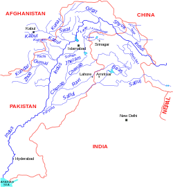
31°56′N69°19′E / 31.933°N 69.317°E / 31.933; 69.317