The Adams River is in the South Island of New Zealand. The headwaters are on the western side of the Southern Alps. It flows into the Wanganui River.

The Mackenzie River is a river in the South Island of New Zealand.

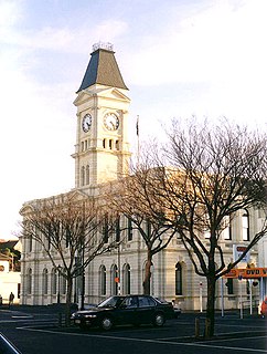
Kurow is a small town in the Waitaki District, New Zealand. It is located on the south bank of the Waitaki River, 60 kilometres (37 mi) northwest of Oamaru. At the 2013 Census, the town had a population of 312 people.
Waitaki District is a territorial authority that is located in the Canterbury and Otago regions of the South Island of New Zealand, and it straddles the traditional border between the two regions, the Waitaki River.
The Hakataramea River flows generally south through the Hakataramea Valley, which is separated from the more inland Mackenzie Basin by the Kirkliston Range in Canterbury, New Zealand.
The Grays River is a tributary of the Tekapo River in the Mackenzie Basin of New Zealand. It flows southwest for 25 kilometres (16 mi), joining the larger river southeast of Lake Pukaki.

Kurów(listen) is a village in south-eastern Poland, located in the historic province of Lesser Poland, between Puławy and Lublin, on the Kurówka River. It is capital of a separate gmina (municipality) called Gmina Kurów, within Lublin Voivodeship. The village has 2,817 inhabitants.

Ngapara is a locality in the north Otago region of New Zealand's South Island. It is located in a rural setting 25 km inland from Oamaru. The name of Ngapara is derived from the Māori word for the "tables" or plateaus of limestone in the area.
The Kurow Branch was part of New Zealand's national rail network. In the North Otago region of the South Island, it was built in the 1870s to open up the land behind Oamaru for development, and closed in 1983.
The Maerewhenua River, also known as the Marewhenua River, is a small river in the Otago region of New Zealand's South Island. It is located in North Otago and acts as a tributary of the Waitaki River, which forms the border between Otago and Canterbury.
Hakataramea, spelt Hakateramea in some older sources, is a rural village located in the southern Canterbury region of New Zealand's South Island. It is in the Waimate District and sits on the north bank of the Waitaki River at its confluence with the Hakataramea River.
Wheatstone is a locality in the Canterbury region of New Zealand's South Island. It is located on the Canterbury Plains south of Ashburton, on the banks of the Ashburton River. Other nearby settlements include Huntingdon to the north, Eiffelton and Flemington to the west, Ashton and Waterton to the south, and Riverside and Wakanui to the east on the opposite side of the Ashburton River. Wheatstone is slightly inland from the coastline of the Pacific Ocean.
The Lambert River is a river of the West Coast Region of New Zealand's South Island. It flows north from the Lambert Glacier in the Southern Alps, joining with the Wanganui River 15 kilometres (9 mi) southeast of Harihari.
The Little Awakino River is a river of North Otago, New Zealand. A tributary of the Waitaki River, it flows into that river a short distance downstream of Lake Waitaki.
The Little Opawa River is a river of the south Canterbury Region of New Zealand's South Island. It flows generally east from a ridge 20 kilometres (12 mi) southwest of Fairlie, joining with its southern neighbour, the Ōpaoa River very close to their joint outflow into the Tengawai River, close to the settlement of Albury.
The Otamatapaio River is a river in North Otago, New Zealand. It rises in the Hawkdun Range and flows north-eastward into Lake Benmore.

State Highway 83 is a South Island state highway in New Zealand running up the Waitaki Valley between the settlements of Pukeuri and Omarama. It forms part of the southernmost of the east-west roads crossing the South Island.
The White Rock River is a river in the South Canterbury area of New Zealand. It rises south of the 1,525 metres (5,003 ft) Mount Nimrod / Kaumira in the Hunter Hills and flows northeast then north to joint the Pareora River.
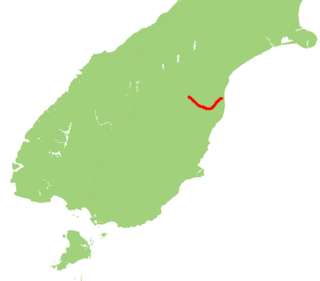
State Highway 82 (SH 82) is a minor east-west South Island state highway in South Canterbury connecting SH 1 at the locality of Hook to SH 83 at the settlement of Kurow in the Waitaki Valley via the major town of Waimate. It is a two lane single carriageway.


