
A Canadian postal code is a six-character string that forms part of a postal address in Canada. Like British, Irish and Dutch postcodes, Canada's postal codes are alphanumeric. They are in the format A1A 1A1, where A is a letter and 1 is a digit, with a space separating the third and fourth characters. As of October 2019, there were 876,445 postal codes using Forward Sortation Areas from A0A in Newfoundland to Y1A in Yukon.

The Quasi-Zenith Satellite System (QZSS), also known as Michibiki (みちびき), is a four-satellite regional satellite navigation system and a satellite-based augmentation system developed by the Japanese government to enhance the United States-operated Global Positioning System (GPS) in the Asia-Oceania regions, with a focus on Japan. The goal of QZSS is to provide highly precise and stable positioning services in the Asia-Oceania region, compatible with GPS. Four-satellite QZSS services were available on a trial basis as of 12 January 2018, and officially started on 1 November 2018. A satellite navigation system independent of GPS is planned for 2023 with seven satellites. In May 2023 it was announced that the system would expand to eleven satellites.

Haplogroup L1 is a human mitochondrial DNA (mtDNA) haplogroup. It is most common in Central Africa and West Africa. It diverged from L1-6 at about 140,000 years ago . Its emergence is associated with the early peopling of Africa by anatomically modern humans during the Eemian, and it is now mostly found in African pygmies.

GPS signals are broadcast by Global Positioning System satellites to enable satellite navigation. Receivers on or near the Earth's surface can determine location, time, and velocity using this information. The GPS satellite constellation is operated by the 2nd Space Operations Squadron (2SOPS) of Space Delta 8, United States Space Force.
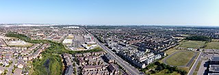
Springdale is an old rural community of Brampton, Ontario, Canada covering 4,000 acres (1,600 ha) in the northern part of the city. It is generally bounded by Countryside Drive to the north, Bovaird Drive to the south, Heart Lake Road to the west, and Airport Road to the east. Springdale is sometimes referred to Singhdale due to its large population of Sikh Canadians, who make up 39.6% of the community's population and often have the last name Singh.

USA-289, also known as GPS-III SV01 or Vespucci, is a United States navigation satellite which forms part of the Global Positioning System. It was the first GPS Block III satellite to be launched.
This page is based on this
Wikipedia article Text is available under the
CC BY-SA 4.0 license; additional terms may apply.
Images, videos and audio are available under their respective licenses.