
Caracas, officially Santiago de León de Caracas (CCS), is the capital and largest city of Venezuela, and the center of the Metropolitan Region of Caracas. Caracas is located along the Guaire River in the northern part of the country, within the Caracas Valley of the Venezuelan coastal mountain range. The valley is close to the Caribbean Sea, separated from the coast by a steep 2,200-meter-high (7,200 ft) mountain range, Cerro El Ávila; to the south there are more hills and mountains. The Metropolitan Region of Caracas has an estimated population of almost 5 million inhabitants.
Cañonero II was a Venezuelan champion Thoroughbred race horse that may be best remembered for winning the first two legs of the 1971 U.S. Triple Crown, the Kentucky Derby and the Preakness Stakes.

Yanahuara District is a suburb within the city of Arequipa, Peru. Yanahuara is well known for its buildings built from sillar, a pearly white volcanic rock. At least 1/4 of the district's area is taken by "Umacollo", where various middle-class residential houses of the city are located. Yanahuara includes the popular avenue strip known as the "Avenida Ejército", where many banks and modern offices are also located. Its surroundings contain various well-cared churches of the Spanish-colonial era, as well as public parks and the well-known "el mirador e iglesia de Yanahuara", a popular spot where tourists concur to view the city and its background volcanoes.

The Los Teques Metro is a suburban mass-transit system in the city of Los Teques, Venezuela with connections to important surrounding cities and communities. It was opened to public service on November 3, 2006. The Los Teques Metro currently operates one service connecting 5 stations, with additional stations for Line 2 under construction.
Navarredonda de la Rinconada, part of the autonomous community of Castile-Leon, is a village and municipality in the western province of Salamanca in Spain. It is located 68 kilometres (42 mi) from the provincial capital city of Salamanca and has a population of 185 people.

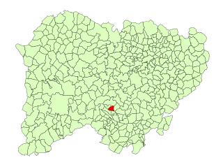
La Rinconada de la Sierra is a village and municipality in the province of Salamanca, western Spain, part of the autonomous community of Castile-Leon. It is located 57 kilometres (35 mi) from the provincial capital city of Salamanca and has a population of 120 people.

The State Railways Institution is a state-run organization of Venezuela that manages the railway systems of the country. Its headquarters are located in Caracas, Venezuela.

Gustavo Ávila is a retired jockey in Thoroughbred horse racing. He is best known as the jockey who rode Canonero II to victory in two of the 1971 U.S. Triple Crown series, the Kentucky Derby and Preakness Stakes. Among his other accomplishments, Avila was the winner of the first Clásico del Caribe (1966) with Victoreado and was the leading rider at La Rinconada Hippodrome for five years.

The Poliedro de Caracas is an indoor sports arena, located on the grounds adjacent to Hipodromo La Rinconada, in Caracas, Venezuela. It was designed by architect Thomas C. Howard of Synergetics, Inc., in Raleigh, NC, in 1971. However, the geodesic dome was not concluded, until 1974, when US firm Charter Industries, along with Synergetics, Inc. designed and manufactured the geodesic dome in Raleigh, NC.

La Rinconada is a municipality located in the province of Seville, Andalusia, Spain. According to the 2020 census (INE), the city has a population of 39,062 inhabitants.
Liliam Cuenca is a Cuban artist. She studied at the Escuela Nacional de Bellas Artes "San Alejandro" in Havana.

Rinconada Bikol or simply Rinconada, spoken in the province of Camarines Sur, Philippines, is one of several languages that compose the Inland Bikol group of the Bikol macrolanguage. It belongs to the Austronesian language family that also includes most Philippine languages, the Formosan languages of Taiwanese aborigines, Malay, the Polynesian languages and Malagasy.

La Rinconada Hippodrome is a race track for Thoroughbred horse racing located in Coche, a neighborhood of south Caracas, Venezuela. It was designed by Arthur Froehlich and opened on July 5, 1959. This track is the #1 course in the country known to host a number of major races with some of the best jockeys in the world participating every year.
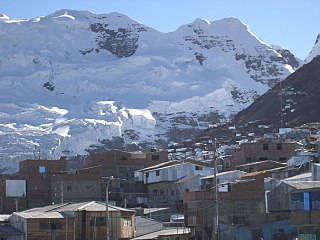
La Rinconada is a town in the Peruvian Andes near a gold mine. At up to 5,100 m above sea level, it is the highest permanent settlement in the world.

The 2010 ISF Women's World Championship was an international softball competition held at Estadio La Rinconada and Estadio Fuerte Tiuna in Caracas, Venezuela from June 23 to July 2, 2010. It was the 12th edition of the tournament.
Junior Rafael Alvarado is a jockey in the sport of Thoroughbred racing who rode his first winner on December 30, 2005, at La Rinconada Hippodrome near Caracas, Venezuela before moving to ride in the United States in 2007 where he got his first winner on February 17 at Gulfstream Park in Hallandale Beach, Florida.

El Valle is a Caracas Metro station on Line 3. It was opened on 18 December 1994 as the southern terminus of the inaugural section of Line 3 from Plaza Venezuela to El Valle. The station is between La Bandera and Los Jardines. On 15 October 2006 the line was extended south to La Rinconada, but the intermediate stations were only opened on 9 January 2010.
The 2023 Caribbean Series was the 65th edition of the Caribbean Series, played at La Rinconada Baseball Stadium in Caracas and Jorge Luis García Carneiro Stadium in La Guaira, Venezuela from February 2 to February 10, 2023.

La Rinconada Baseball Stadium also known as Monumental Stadium of Caracas Simón Bolívar is a modern baseball stadium in the city of Caracas, specifically in the sector of La Rinconada next to the Poliedro de Caracas, the Rinconada Racetrack and the future Venezuelan National Football Stadium in the so-called "Hugo Chávez " Park in the Coche parish, south of the Libertador municipality and the Capital District and west of the metropolitan area of Caracas in Venezuela.