
Quttinirpaaq National Park is a Canadian national park. Located on the northeastern corner of Ellesmere Island in the Qikiqtaaluk Region of Nunavut, the most northerly extent of Canada, it is the second most northerly park on Earth after Northeast Greenland National Park. In Inuktitut, Quttinirpaaq means "top of the world". It was established as Ellesmere Island National Park Reserve in 1988, and the name was changed to Quttinirpaaq in 1999, when Nunavut was created, and became a national park in 2000.
The reserve covers 37,775 square kilometres (14,585 sq mi), making it the second largest park in Canada, after Wood Buffalo National Park.

The Kivalliq Region is an administrative region of Nunavut, Canada. It consists of the portion of the mainland to the west of Hudson Bay together with Southampton Island and Coats Island. The regional seat is Rankin Inlet. The population was 10,413 in the 2016 Census, an increase of 16.3% from the 2011 Census.
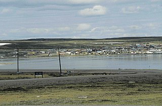
Baker Lake is a hamlet in the Kivalliq Region, in Nunavut on mainland Canada. Located 320 km (200 mi) inland from Hudson Bay, it is near the nation's geographical centre, and is notable for being the Canadian Arctic's sole inland community. The hamlet is located at the mouth of the Thelon River on the shore of Baker Lake. The community was given its English name in 1761 from Captain William Christopher who named it after Sir William Baker, the 11th Governor of the Hudson's Bay Company.

Cornwall Island is a small island in the high arctic region of the Canadian territory of Nunavut. It is near the geometric centre of the Queen Elizabeth Islands. To the north, it is separated from Amund Ringnes Island by Hendriksen Strait. To the south, it is separated from Devon Island by Belcher Channel. It is the largest of six islands in the Norwegian Bay, west of Ellesmere Island.

Russell Island is an uninhabited island of the Canadian Arctic Archipelago in the Qikiqtaaluk Region of Nunavut, Canada. It is located in the Parry Channel, separated from the northern tip of Prince of Wales Island by the narrow Baring Channel. The western third of the island is separated from the other two thirds by a narrow lake and its outlet. At the northern end of the lake there is an isthmus just 1.1 km (0.68 mi) wide and this joins the two parts of the island. With a total area of 940 km2 (360 sq mi), it is the largest island offshore of Prince of Wales Island.

Nunavut Arctic College is a Crown corporation that is funded by the Government of Nunavut and has several campuses and centres spread out throughout Nunavut, Canada.
Baker Lake is a lake in the Kivalliq Region, Nunavut, Canada. It is fed by the Thelon River from the west and the Kazan River from the south. Its outflows into Chesterfield Inlet. The lake is approximately 1,887 km2 (729 sq mi) in size. It has several named bays, and a few islands.

Whale Cove, is a hamlet located 74 km (46 mi) south southwest of Rankin Inlet, 145 km (90 mi) northeast of Arviat, in Kivalliq Region, Nunavut, Canada, on the western shore of Hudson Bay.
Baker Lake is a territorial electoral district (riding) for the Legislative Assembly of Nunavut, Canada. The riding consists of the community of Baker Lake. The current Member of the Legislative Assembly is Simeon Mikkungwak.
Skraeling Island lies off the east coast of Ellesmere Island in the Canadian territory of Nunavut, at the mouth of Alexandra Fiord. Buchanan Bay lies to its north-east.
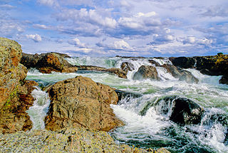
The Kazan River, is a Canadian Heritage River located in Nunavut, Canada. The Dene name for the river was Kasba-tue meaning "white partridge river." The name was apparently changed to Kazan in the late 19th century due to the influence of Order of Mary Immaculate missionaries. The river headwaters are in northern Saskatchewan at Kasba Lake, and it flows north for about 1000 km (621 mi) before emptying into Baker Lake, on the opposite side of the mouth of the Thelon River. Along its course the river flows through several lakes, including Ennadai Lake and Yathkyed Lake, over the Kazan Falls, down a red sandstone gorge and through both boreal forest and tundra. It is the last section of the river, below Ennadai Lake, that is above the timber line and is designated a Canadian Heritage River.
The Canadian territory of Nunavut covers about 1.9 million square kilometres of land and water including part of the mainland, most of the Arctic Islands, and all of the islands in Hudson Bay, James Bay, and Ungava Bay which belonged to the Northwest Territories. This makes it the fifth largest country subdivision in the world. If Nunavut were a country, it would rank 13th in area, after the Democratic Republic of the Congo. Nunavut has land borders with Manitoba, the Northwest Territories on several islands as well as the mainland, and a tiny land border with Newfoundland and Labrador on Killiniq Island. Nunavut also has small land borders with Ontario and Quebec.

Nunavut is the newest, largest, and most northerly territory of Canada. It was separated officially from the Northwest Territories on April 1, 1999, via the Nunavut Act and the Nunavut Land Claims Agreement Act, though the boundaries had been drawn in 1993. The creation of Nunavut resulted in the first major change to Canada's political map since the incorporation of the province of Newfoundland in 1949.
Buchanan Bay is an Arctic waterway in Qikiqtaaluk Region, Nunavut, Canada. It is located in Nares Strait by eastern Ellesmere Island. The bay is bordered by Cape Camperdown on Bache Peninsula to the north, Cape Rutherford on Johan Peninsula to the south, and the Alexandra Fiord at its head.

Tulemalu Lake is a lake in Kivalliq Region, Nunavut, Canada.

Napaktulik Lake, also known as Takiyuak Lake or Takijuq Lake, is the eighth largest lake in Nunavut, Canada. It is located 173 km south of Kugluktuk.
The Buchanan Lake Formation is a geologic formation in Nunavut. It preserves fossils dating back to the Paleogene period.

