
Dhilba Guuranda–Innes National Park, formerly Innes National Park, is an IUCN-designated protected area in the Australian state of South Australia located on the southwest tip of Yorke Peninsula about 300 kilometres (190 mi) west of the state capital of Adelaide. It is a popular destination for camping, bushwalking, fishing, surfing and scuba diving.

Shoemaker is an impact structure, the deeply eroded remnant of a former impact crater, situated in arid central Western Australia, about 100 km (62 mi) north-northeast of Wiluna. It is named in honour of planetary geologist Eugene Shoemaker.
The 1962 British Empire and Commonwealth Games was held in Perth, Western Australia, from 22 November to 1 December 1962. Athletic events were held at Perry Lakes Stadium in the suburb of Floreat and swimming events at Beatty Park in North Perth. It was held after the 1962 Commonwealth Paraplegic Games for wheelchair athletes.

The Gibson Desert is a large desert in Western Australia, largely in an almost pristine state. It is about 155,000 square kilometres (60,000 sq mi) in size, making it the fifth largest desert in Australia, after the Great Victoria, Great Sandy, Tanami and Simpson deserts. The Gibson Desert is both an interim Australian bioregion and desert ecoregion.

The Wheatbelt is one of nine regions of Western Australia defined as administrative areas for the state's regional development, and a vernacular term for the area converted to agriculture during colonisation. It partially surrounds the Perth metropolitan area, extending north from Perth to the Mid West region, and east to the Goldfields–Esperance region. It is bordered to the south by the South West and Great Southern regions, and to the west by the Indian Ocean, the Perth metropolitan area, and the Peel region. Altogether, it has an area of 154,862 square kilometres (59,793 sq mi).

Wagin is a town and shire in the Wheatbelt region of Western Australia, approximately 225 km (139.81 mi) south-east of Perth on the Great Southern Highway between Narrogin and Katanning. It is also on State Route 107. The main industries are wheat and sheep farming.

The West Coast Range is a mountain range located in the West Coast region of Tasmania, Australia.

The Swan Coastal Plain in Western Australia is the geographic feature which contains the Swan River as it travels west to the Indian Ocean. The coastal plain continues well beyond the boundaries of the Swan River and its tributaries, as a geological and biological zone, one of Western Australia's Interim Biogeographic Regionalisation for Australia regions. It is also one of the distinct physiographic provinces of the larger West Australian Shield division.
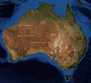
The deserts of Australia or the Australian deserts cover about 2,700,000 km2 (1,000,000 sq mi), or 18% of the Australian mainland, but about 35% of the Australian continent receives so little rain, it is practically desert. Collectively known as the Great Australian desert, they are primarily distributed throughout the Western Plateau and interior lowlands of the country, covering areas from South West Queensland, Far West region of New South Wales, Sunraysia in Victoria and Spencer Gulf in South Australia to the Barkly Tableland in Northern Territory and the Kimberley region in Western Australia.
The Pintupi are an Australian Aboriginal group who are part of the Western Desert cultural group and whose traditional land is in the area west of Lake Macdonald and Lake Mackay in Western Australia. These people moved into the Aboriginal communities of Papunya and Haasts Bluff in the west of the Northern Territory in the 1940s–1980s. The last Pintupi to leave their traditional lifestyle in the desert, in 1984, are a group known as the Pintupi Nine, also sometimes called the "lost tribe".

Mallee, also known as Roe Botanical District, is a biogeographic region in southern Western Australia. Located between the Esperance Plains, Avon Wheatbelt and Coolgardie bioregions, it has a low, gently undulating topography, a semi-arid mediterranean climate, and extensive Eucalyptus mallee vegetation. It has an area of 73,975.59 square kilometres (28,562.13 sq mi). About half of the region has been cleared for intensive agriculture. Recognised as a region under the Interim Biogeographic Regionalisation for Australia (IBRA), it was first defined by John Stanley Beard in 1980.

Lake King is a town in the eastern Wheatbelt region of Western Australia, 464 kilometres (288 mi) from Perth along State Route 40 between Kelmscott and Ravensthorpe. As of 2016, the town had a population of 95. The 2011 census recorded both the population of the town and the surrounding area for a population of 332.
Lake Gregory – Mulan Airport is an airport located in Mulan, serving Lake Gregory region, Western Australia.
Lockhart River is a river in the Wheatbelt region of Western Australia. It is a sub-catchment of the Avon River, and has an area of 32,400 square kilometres (12,500 sq mi). At its junction with the Yilgarn River to form the Salt River, it passes through a hydrological-topographical pinch-point at 'Caroline Gap'.

Highways and main roads in the Wheatbelt region of Western Australia form the basis of a road network, which is primarily used by the mining, agriculture, and tourism industries. Main Roads Western Australia maintains and controls these major roads, with offices based in Northam and Narrogin.
Lake Martin, a shallow 2,200-hectare (5,400-acre) Freshwater lake on the Woady Yaloak River, is located in the Western District Lakes region of southwest Victoria, in Australian. The lake is situated adjacent to, and upstream from, the hypersaline Lake Corangamite. It is a shallow lake with a depth of less than 5 metres.
The Mandjindja, Mantjintjarra or Manytjilytjarra are an Aboriginal Australian people of Western Australia belonging to the Western Desert cultural bloc.
The following index is provided as an overview of and topical guide to Wikipedia's articles on recreational dive sites. The level of coverage may vary:


