Related Research Articles

Red River County is a county in the U.S. state of Texas. As of the 2020 census, its population was 11,587. Its county seat is Clarksville. The county was created in 1835 and organized in 1837. It is named for the Red River, which forms its northern boundary. Red River County was the birthplace of John Nance Garner, 32nd Vice President of the United States.
Lavaca County is a county located in the U.S. state of Texas. As of the 2020 census, its population was 20,337. Its county seat is Hallettsville. The county was created in 1846. It is named for the Lavaca River, which curves its way southeast through Moulton and Hallettsville before reaching the coast at Matagorda Bay.

Hardeman County is a county located in the U.S. state of Texas. As of the 2020 census, its population was 3,549. The county seat and largest city is Quanah. The county was created in 1858 and later organized in 1884. It is named for two brothers, Bailey Hardeman and Thomas Jones Hardeman, early Texas politicians and legislators. Hardeman County was one of 46 prohibition or entirely dry counties in the state of Texas until November 2006, when voters approved referendums to permit the legal sale of alcoholic beverages for on- and off-premises consumption.

Delta County is a county located in the U.S. state of Texas. As of the 2020 census, its population was 5,230. Its county seat and largest city is Cooper. The county was founded in 1870 and is named for its triangular shape, which resembles the Greek letter delta.

Crockett County is a county located on the Edwards Plateau in the U.S. state of Texas. As of the 2020 census, its population was 3,098. The county seat is Ozona. The county was founded in 1875 and later organized in 1891. It is named in honor of Davy Crockett, the legendary frontiersman who died at the Battle of the Alamo.
North Fort Myers is an unincorporated area and census-designated place (CDP) in Lee County, Florida, United States. The population was 42,719 at the 2020 census, up from 39,407 at the 2010 census. It is part of the Cape Coral-Fort Myers, Florida Metropolitan Statistical Area.

Old River-Winfree is a city in Chambers and Liberty counties, Texas, United States. The population was 1,315 at the 2020 census.

The Adams–Onís Treaty of 1819, also known as the Transcontinental Treaty, the Spanish Cession, the Florida Purchase Treaty, or the Florida Treaty, was a treaty between the United States and Spain in 1819 that ceded Florida to the U.S. and defined the boundary between the U.S. and Mexico. It settled a standing border dispute between the two countries and was considered a triumph of American diplomacy. It came during the successful Spanish American wars of independence against Spain.
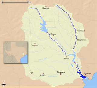
The San Jacinto River flows through southeast Texas. It is named after Saint Hyacinth. In the past, it was home to the Karankawa and Akokisa tribes.
Glenarm is a community in the City of Kawartha Lakes of about 80 people. Very few people live in the actual hamlet itself, but the community spreads about 2 km in each direction.
The Devils River in southwestern Texas, part of the Rio Grande drainage basin, has limited areas of whitewater along its length. It begins in northwest Sutton County, at 30°19′40″N100°56′31″W, where six watercourses come together, Dry Devils River, Granger Draw, House Draw, Jackson, Flat Rock Draw, and Rough Canyon. It flows southwest for 94 miles (151 km) through Val Verde County and empties into the northeastern shore of the Amistad Reservoir, an impoundment of the Rio Grande near Del Rio, Texas on the Texas/Mexico border, 29°27′33″N101°3′34″W. The discharge of the Devils River, as measured at IBWC gaging station 08-4494.00 near the river's mouth, averages 362 cubic feet per second (10.3 m3/s), with a maximum of 122,895 cubic feet per second (3,480 m3/s) and a minimum of 54 cubic feet per second (1.53 m3/s). Its drainage basin above that point is 10,259 square kilometres (3,961 sq mi).
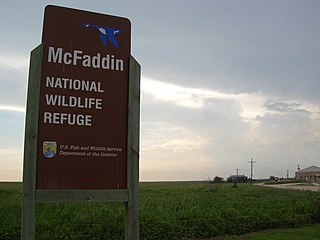
The McFaddin and Texas Point National Wildlife Refuges are located in proximity in southern Jefferson County on the upper Texas coast at Sabine Pass. The refuges have a combined 105.96 square miles (274.4 km2) of fish and wildlife habitat. McFaddin, much the larger one, located at around 29°40′00″N94°09′00″W, has a total area of 58,861.43 acres (238.2038 km2), while the smaller Texas Point, located at around 29°42′00″N93°53′00″W, has 8,952.02 acres (36.2275 km2).
There are over a dozen lakes named Mud Lake within the U.S. state of Texas.
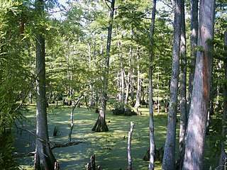
Cypress Bayou is the name applied to a series of wetlands at the western edge of Caddo Lake, in and around Jefferson, Texas, making up part of the largest Cypress forest in the world. The bayou is divided into three areas—each part of the watershed of a small river or creek—Little Cypress, Big Cypress, and Black Cypress. The features had been modified, to an extent, by human beings in the 19th and 20th centuries, but today is endangered by pollution, development, and the deforestation, through clear cutting, of the Piney Woods that surround the bayous. Large groves of trees have completely died off, and land has been recently deforested up to the water's edge.
City of Waco was an American steamship which sank with much loss of life on November 9, 1875, in the Gulf of Mexico off Galveston, Texas.
Highland Bayou is a river in Texas.
All Saints Episcopal School is an independent, private school in Lubbock, Texas. With approximately 450 students, the school serves children from age three through high school. All Saints nurtures growth in its students with focus in the areas of academics, fine arts, athletics, spiritual growth and community service.

West Bay, also referred to as West Galveston Bay, is a long inlet of Galveston Bay in Galveston and Brazoria counties that nearly runs the entire length west of Galveston Island.
English is an unincorporated community in northeastern Red River County, Texas, United States, 11 miles (18 km) northeast of Clarksville.

The Texas Capitol Vietnam Veterans Monument, is a memorial designed by New Mexico artist Duke Sundt, installed on the grounds of the Texas State Capitol in Austin, Texas, United States. It serves as a tribute to all Texans who served in the Vietnam War and a memorial to the 3,417 who died. Ground was broken on March 25, 2013 on the northeast side of the Capitol. The monument was dedicated on March 29, 2014.
References
- "An Analysis of Texas Waterways" . Retrieved 2006-05-04.
- USGS Hydrologic Unit Map - State of Texas (1974)
29°53′04″N94°44′20″W / 29.8844°N 94.7390°W
| | This article related to a river in Texas is a stub. You can help Wikipedia by expanding it. |