See also
| This disambiguation page lists articles about distinct geographical locations with the same name. If an internal link led you here, you may wish to change the link to point directly to the intended article. |
Lake Davis may refer to:
| This disambiguation page lists articles about distinct geographical locations with the same name. If an internal link led you here, you may wish to change the link to point directly to the intended article. |

Plumas County is a county in the Sierra Nevada of California, United States. As of the 2010 census, the population was 20,007. The county seat is Quincy, and the only incorporated city is Portola. The largest community in the county is East Quincy. The county was named for the Spanish Río de las Plumas, which flows through the county.

Lake Davis is a census-designated place (CDP) in Plumas County, California, United States. The population was 45 at the 2010 census.

Portola is the only incorporated city in Plumas County, California, United States. The population was 2,104 at the 2010 census, down from 2,227 at the 2000 census. Portola is located on the Middle Fork of the Feather River, and was named after Spanish explorer Gaspar de Portolà, although he did not explore this area. The name is generally mispronounced in an anglicized way, with stress on the middle syllable, thus ignoring the accent mark in its namesake's surname.

The Shasta Cascade region of California is located in the northeastern and north-central sections of the state bordering Oregon and Nevada, including far northern parts of the Central Valley and the Sierra Nevada mountain range.

Plumas Lake is a master-planned exurb and census-designated place in Yuba County, California. Plumas Lake is located 30 miles (48 km) north of the city of Sacramento on the Feather River, just prior to its confluence with the Bear River and the Sacramento River. At full build-out the city will have roughly 12,000 homes and 36,000 residents. The community is located about 10 miles (16 km) south of the city of Marysville in southern Yuba County. It lies at an elevation of 46 feet. The population was 5,853 at the 2010 census.

Roop County is a defunct county of Nevada. It was created as Lake County in 1861 as one of the original nine counties of Nevada. The name Lake County was chosen due to the many lakes in the area, including Honey Lake, Pyramid Lake, and Winnemucca Lake.

Tahoe National Forest is a United States National Forest located in California, northwest of Lake Tahoe. It includes the 8,587-foot (2,617 m) peak of Sierra Buttes, near Sierra City, which has views of Mount Lassen and Mount Shasta. It is located in parts of six counties: Sierra, Placer, Nevada, Yuba, Plumas and El Dorado. The forest has a total area of 871,495 acres. Its headquarters is in Nevada City, California. There are local ranger district offices in Camptonville, Foresthill, Sierraville and Truckee.

Plumas National Forest is a 1,146,000-acre (4,638 km2) United States National Forest located at the northern terminus of the Sierra Nevada, in northern California. The Forest was named after its primary watershed, the Rio de las Plumas, which was later anglicized to "Feather River".

State Route 70 is a state highway in the U.S. state of California, connecting SR 99 north of Sacramento with U.S. Route 395 near Beckwourth Pass via the Feather River Canyon. Through the Feather River Canyon, from SR 149 to US 395, SR 70 is the Feather River Scenic Byway, a Forest Service Byway that parallels the ex-Western Pacific Railroad's Feather River Route.
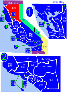
Area code 530 is a California telephone area code in northeastern and Northern California.
The Nataqua Territory was a short-lived, unofficial territory of the United States. It consisted of a portion of what is now northeastern California and northwestern Nevada. In 1849, the border between California and the Utah Territory was defined by geographical coordinates that were not surveyed. On April 26, 1856, local residents took advantage of this ambiguity and justified their resistance to tax collectors from Plumas County, California, by proclaiming themselves part of a new "Territory of Nataqua." The twenty men of the Susanville convention who announced the Nataqua Territory had defined a rectangle-shaped territory by latitude and longitude, which inadvertently did not include their own Honey Lake Valley but did encompass most of what soon became western Nevada, along with 600 unsuspecting inhabitants. The Territory of Nataqua was a frontier land club or claim association, designed to protect the property rights of individual settlers until regular government reached the area. The movement was led by Peter Lassen and Isaac Roop. Association with the Utah Territory was unpalatable to the residents due to anti-Mormonism.
Lake Davis is an artificial lake in Plumas County, California near the Sierra Nevada community of Portola. Its waters are impounded by Grizzly Valley Dam, which was completed in 1966. The lake is named for Lester T. Davis (1906-1952).
Plumas may refer to:

The Middle Fork Feather River is a major river in Plumas and Butte Counties in the U.S. state of California. Nearly 100 miles (160 km) long, it drains about 1,062 square miles (2,750 km2) of the rugged northern Sierra Nevada range.
Plumas-Eureka State Park is a California state park located in the Sierra Nevada and Cascade Range in Plumas County, California.

The Bucks Lake Wilderness is a 23,958-acre (97.0 km2) wilderness area located in the Plumas National Forest section of the Sierra Nevada, in northeastern California, United States.
Murphy Lake is a lake in Plumas County, California, United States.
Las Plumas is a former settlement in Butte County, California.
Little Grass Valley Reservoir is an artificial lake in Plumas County, California and Plumas National Forest near the Pacific Crest Trail.

The Walker Fire was a wildfire that was burning in Genesee Valley in the Plumas National Forest approximately 11 miles east of the community of Taylorsville in Plumas County, California. The blaze was reported on Wednesday, September 4, 2019 and immediately expanded in size over its several days of burning. The fire is actively threatening homes from Genesee Valley to Antelope Road. As of September 14, the Walker Fire has burned 54,612 acres (22,101 ha) and is 97 percent contained. Select areas of Plumas National Forest remain closed.