In earth science, erosion is the action of surface processes that removes soil, rock, or dissolved material from one location on the Earth's crust, and then transports it to another location. This natural process is caused by the dynamic activity of erosive agents, that is, water, ice (glaciers), snow, air (wind), plants, animals, and humans. In accordance with these agents, erosion is sometimes divided into water erosion, glacial erosion, snow erosion, wind (aeolic) erosion, zoogenic erosion, and anthropogenic erosion. The particulate breakdown of rock or soil into clastic sediment is referred to as physical or mechanical erosion; this contrasts with chemical erosion, where soil or rock material is removed from an area by its dissolving into a solvent, followed by the flow away of that solution. Eroded sediment or solutes may be transported just a few millimetres, or for thousands of kilometres.

Geomorphology is the scientific study of the origin and evolution of topographic and bathymetric features created by physical, chemical or biological processes operating at or near the Earth's surface. Geomorphologists seek to understand why landscapes look the way they do, to understand landform history and dynamics and to predict changes through a combination of field observations, physical experiments and numerical modeling. Geomorphologists work within disciplines such as physical geography, geology, geodesy, engineering geology, archaeology, climatology and geotechnical engineering. This broad base of interests contributes to many research styles and interests within the field.

The Intermontane Plateaus of the Western United States is one of eight U.S. Physiographic regions (divisions) of the physical geography of the contiguous United States. The region is composed of intermontane plateaus and mountain ranges. It is subdivided into physiographic provinces, which are each subdivided into physiographic sections.

A drainage basin is any area of land where precipitation collects and drains off into a common outlet, such as into a river, bay, or other body of water. The drainage basin includes all the surface water from rain runoff, snowmelt, and nearby streams that run downslope towards the shared outlet, as well as the groundwater underneath the earth's surface. Drainage basins connect into other drainage basins at lower elevations in a hierarchical pattern, with smaller sub-drainage basins, which in turn drain into another common outlet.

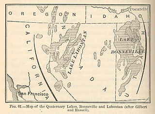
An endorheic basin is a limited drainage basin that normally retains water and allows no outflow to other external bodies of water, such as rivers or oceans, but converges instead into lakes or swamps, permanent or seasonal, that equilibrate through evaporation. Such a basin may also be referred to as a closed or terminal basin or as an internal drainage system or interior drainage basin.
Lake Makgadikgadi was a paleolake that existed in what is now the Kalahari Desert in Botswana from 2,000,000 years BP to 10,000 years BP. It may have once covered an area of from 80,000 km² to 275,000 km² and was 30 m deep. The Okavango, Upper Zambezi, and Cuando rivers once all emptied into the lake. Its remains are seen in the Makgadikgadi salt pans, one of the largest salt pans in the world.

Terrain or relief involves the vertical and horizontal dimensions of land surface. The term bathymetry is used to describe underwater relief, while hypsometry studies terrain relative to sea level. The Latin word terra means "earth."

The Eastern Continental Divide or Eastern Divide or Appalachian Divide is a hydrographic divide in eastern North America that separates the easterly Atlantic Seaboard watershed from the westerly Gulf of Mexico watershed. The divide nearly spans the United States from south of Lake Ontario through the Florida peninsula, and consists of raised terrain including the Appalachian Mountains to the north, the southern Piedmont Plateau and lowland ridges in the Atlantic Coastal Plain to the south. Water including rainfall and snowfall, lakes, streams and rivers on the eastern/southern side of the divide drains to the Atlantic Ocean; water on the western/northern side of the divide drains to the Gulf of Mexico. The ECD is one of six continental hydrographic divides of North America which define several drainage basins, each of which drains to a particular body of water.

In geology and geomorphology a base level is the lower limit for an erosion process. The modern term was introduced by John Wesley Powell in 1875. The term was subsequently appropriated by William Morris Davis who used it in his cycle of erosion theory. The "ultimate base level" is the plane that results from projection of the sea level under landmasses. It is to this base level that topography tends to approach due to erosion, eventually forming a peneplain close to the end of a cycle of erosion.
An inland sea is a shallow sea that covers central areas of continents during periods of high sea level that result in marine transgressions. In modern times, continents stand high, eustatic sea levels are low, and there are few inland seas, the largest being Hudson Bay. Modern examples might also include the recently reflooded Persian Gulf, and the South China Sea that presently covers the Sunda Shelf.

In geology, a terrace is a step-like landform. A terrace consists of a flat or gently sloping geomorphic surface, called a tread, that is typically bounded one side by a steeper ascending slope, which is called a "riser" or "scarp." The tread and the steeper descending slope together constitute the terrace. Terraces can also consist of a tread bounded on all sides by a descending riser or scarp. A narrow terrace is often called a bench.
In geomorphology, a knickpoint or nickpoint is part of a river or channel where there is a sharp change in channel slope, such as a waterfall or lake. Knickpoints reflect different conditions and processes on the river, often caused by previous erosion due to glaciation or variance in lithology. In the cycle of erosion model, knickpoints advance one cycle upstream, or inland, replacing an older cycle.
Open and closed lakes refer to the major subdivisions of lakes - bodies of water surrounded by land. Exorheic, or open lakes drain into a river, or other body of water that ultimately drains into the ocean. Endorheic basins fall into the category of endorheic or closed lakes, wherein waters do not drain into the ocean, but are reduced by evaporation, and/or drain into the ground.
Lacustrine Plains are lakes that get filled by incoming sediment. Over time, the water may drain from the lake, leaving the deposited sediments behind. This can be caused by natural drainage, evaporation or other geophysical processes.

The interaction between erosion and tectonics has been a topic of debate since the early 1990s. While the tectonic effects on surface processes such as erosion have long been recognized, the opposite has only recently been addressed. The primary questions surrounding this topic are what types of interactions exist between erosion and tectonics and what are the implications of these interactions. While this is still a matter of debate, one thing is clear, the Earth's landscape is a product of two factors: tectonics, which can create topography and maintain relief through surface and rock uplift, and climate, which mediates the erosional processes that wear away upland areas over time. The interaction of these processes can form, modify, or destroy geomorphic features on the Earth’s surface.
An ancient lake is a lake that has consistently carried water for more than one million years. Many have existed for more than 2.6 million years, the full Quaternary period. Ancient lakes continue to persist due to plate tectonics in an active rift zone. This active rift zone creates lakes that are extremely deep and difficult to naturally fill with sediment. Due to the prolonged life of ancient lakes, they serve as models for isolated evolutionary traits and speciation.
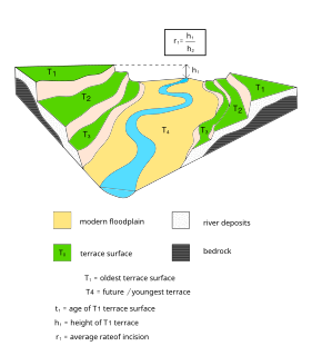
Terraces can be formed in many ways and in several geologic and environmental settings. By studying the size, shape, and age of terraces, one can determine the geologic processes that formed them. When terraces have the same age and/or shape over a region, it is often indicative that a large-scale geologic or environmental mechanism is responsible. Tectonic uplift and climate change are viewed as dominant mechanisms that can shape the earth’s surface through erosion. River terraces can be influenced by one or both of these forcing mechanisms and therefore can be used to study variation in tectonics, climate, and erosion, and how these processes interact.

Lake Corcoran is an ancient lake that covered the Central Valley of California.