
New Hampshire is a state in the New England region of the northeastern United States. It is bordered by Massachusetts to the south, Vermont to the west, Maine and the Gulf of Maine to the east, and the Canadian province of Quebec to the north. Of the 50 U.S. states, New Hampshire is the fifth smallest by area and the tenth least populous, with slightly more than 1.3 million residents. Concord is the state capital, while Manchester is the largest city. New Hampshire's motto, "Live Free or Die", reflects its role in the American Revolutionary War; its nickname, "The Granite State", refers to its extensive granite formations and quarries. It is well known nationwide for holding the first primary in the U.S. presidential election cycle, and for its resulting influence on American electoral politics, leading the adage "As New Hampshire goes, so goes the nation".

Moultonborough is a town in Carroll County, New Hampshire, United States. The population was 4,918 at the 2020 census, up from 4,044 at the 2010 census. Moultonborough is bounded in large part by Lake Winnipesaukee in the southwest and to a lesser extent by Squam Lake in the northwest corner. The town includes the census-designated place of Suissevale and the community of Lees Mill.
Silver Lake may refer to:

U.S. Route 302 is an east–west spur of U.S. Route 2 in northern New England in the United States. It currently runs 171 miles (275 km) from Montpelier, Vermont, beginning at US 2, to Portland, Maine, at U.S. Route 1. It passes through the states of Vermont, New Hampshire and Maine.
Mountain Lake may refer to a location in North America:
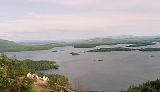
The Lakes Region of New Hampshire is located in the east-central part of the state, south of the White Mountains Region and extending to the Maine border. It is named for the numerous lakes in the region, the largest of which are Lake Winnipesaukee, Lake Winnisquam, Squam Lake, and Newfound Lake. The area comprises all of Belknap County, the southern portion of Carroll County, the eastern portion of Grafton County, and the northern portions of Strafford County and Merrimack County. The largest municipality is the city of Laconia.

New Hampshire Route 25 is a 96.62-mile (155.49 km) long east–west state highway in New Hampshire. It runs completely across the state from Vermont to Maine.

New Hampshire Route 171 is a 15.194-mile-long (24.452 km) east–west highway in southern Carroll County in the Lakes Region of New Hampshire. The highway runs from NH 109 in Moultonborough to NH 16 in Ossipee.

The Lakes of the Clouds are a set of tarns located at the 5,032 ft (1,534 m) col between Mount Monroe and Mount Washington in the White Mountains of the U.S. state of New Hampshire. The lakes form the source of the Ammonoosuc River, a tributary of the Connecticut River. They are recorded by the Geographic Names Information System as the highest elevation lakes in the United States east of South Dakota.

Mount Monroe is a 5,372-foot-high (1,637 m) mountain peak southwest of Mount Washington in the Presidential Range of the White Mountains in New Hampshire, United States. It is named for American President James Monroe and is the fourth highest mountain on the 4000 footers list for New Hampshire. The Appalachian Trail skirts its summit, which is the next highest peak on or near the trail north of Mount Rogers in Virginia. The Lakes of the Clouds, and its AMC hut, lie nestled at the col between Mount Monroe and neighboring Mount Washington.
Cacapon is a term of Native American origin that means "medicine waters." It may refer to:

Mount Chocorua is a 3,490 ft (1,060 m) mountain in the White Mountains of New Hampshire, the easternmost peak of the Sandwich Range. Although the mountain is not outstanding for its elevation, it is very rugged and has excellent views of the surrounding lakes, mountains, and forests. Being at the end of the range, its bare summit can be seen from almost every direction and identified from many points throughout central New Hampshire and western Maine, and it has been the subject of numerous works of art. Many hiking trails ascend the mountain. Scenic Chocorua Lake lies directly to the south.

The Ammonoosuc River is a 55-mile-long (89 km) river in northwestern New Hampshire in the United States. It is a tributary of the Connecticut River, which flows to Long Island Sound. Ammonoosuc is Abnaki for "small, narrow fishing place".

Mount Shaw is a mountain located in the towns of Moultonborough and Tuftonboro in Carroll County, New Hampshire, United States. It is part of the remains of an ancient volcanic ring dike. With a summit elevation of 2,990 feet (911 m), it is the highest of the Ossipee Mountains.
Mirror Lake or Mirror Lakes may refer to:
Emerald Lake may refer to:
Mt. Roberts is a mountain located in Carroll County, New Hampshire. The peak is located within the Lakes Region Conservation Trust's Castle in the Clouds property.
Larcom Mountain is a mountain located in Carroll County, New Hampshire, USA. The top of the mountain, and its subpeak, Little Larcom Mountain, are part of the Lakes Region Conservation Trust.
Prospect Mountain may refer to: