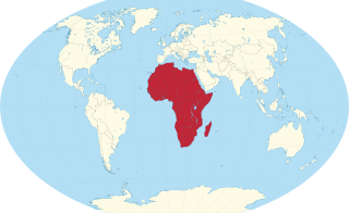
Africa is a continent comprising 63 political territories, representing the largest of the great southward projections from the main mass of Earth's surface. Within its regular outline, it comprises an area of 30,368,609 km2 (11,725,385 sq mi), excluding adjacent islands. Its highest mountain is Kilimanjaro; its largest lake is Lake Victoria.

The geography of Egypt relates to two regions: North Africa and West Asia.

North Africa is a region encompassing the northern portion of the African continent. There is no singularly accepted scope for the region, and it is sometimes defined as stretching from the Atlantic shores of the Western Sahara in the west, to Egypt and Sudan's Red Sea coast in the east.

Spain is a country located in southwestern Europe occupying most of the Iberian Peninsula. It also includes a small exclave inside France called Llívia, as well as the Balearic Islands in the Mediterranean, the Canary Islands in the Atlantic Ocean 108 km (67 mi) off northwest Africa, and five places of sovereignty on and off the coast of North Africa: Ceuta, Melilla, Islas Chafarinas, Peñón de Alhucemas, and Peñón de Vélez de la Gomera.

South Africa occupies the southern tip of Africa, its coastline stretching more than 2,850 kilometres from the desert border with Namibia on the Atlantic (western) coast southwards around the tip of Africa and then northeast to the border with Mozambique on the Indian (eastern) coast. The low-lying coastal zone is narrow for much of that distance, soon giving way to a mountainous escarpment that separates the coast from the high inland plateau. In some places, notably the province of KwaZulu-Natal in the east, a greater distance separates the coast from the escarpment. Although much of the country is classified as semi-arid, it has considerable variation in climate as well as topography. The total land area is 1,220,813 km2 (471,359 sq mi). It has the 23rd largest Exclusive Economic Zone of 1,535,538 km2 (592,875 sq mi).

A canyon, gorge or chasm, is a deep cleft between escarpments or cliffs resulting from weathering and the erosive activity of a river over geologic time scales. Rivers have a natural tendency to cut through underlying surfaces, eventually wearing away rock layers as sediments are removed downstream. A river bed will gradually reach a baseline elevation, which is the same elevation as the body of water into which the river drains. The processes of weathering and erosion will form canyons when the river's headwaters and estuary are at significantly different elevations, particularly through regions where softer rock layers are intermingled with harder layers more resistant to weathering.

East Africa, also known as Eastern Africa or the East of Africa, is a region at the eastern edge of the African continent, distinguished by its geographical, historical, and cultural landscape. Defined in varying scopes, the region is recognized in the United Nations Statistics Division scheme as encompassing 18 sovereign states and 4 territories.
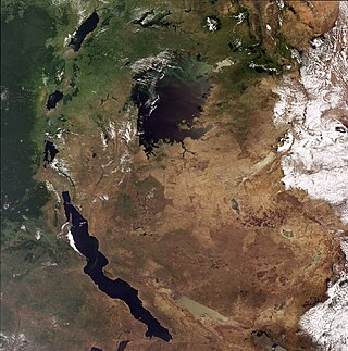
The African Great Lakes are a series of lakes constituting the part of the Rift Valley lakes in and around the East African Rift. The series includes Lake Victoria, the second-largest freshwater lake in the world by area; Lake Tanganyika, the world's second-largest freshwater lake by volume and depth; Lake Malawi, the world's eighth-largest freshwater lake by area; and Lake Turkana, the world's largest permanent desert lake and the world's largest alkaline lake. Collectively, they contain 31,000 km3 (7,400 cu mi) of water, which is more than either Lake Baikal or the North American Great Lakes. This total constitutes about 25% of the planet's unfrozen surface fresh water. The large rift lakes of Africa are the ancient home of great biodiversity, and 10% of the world's fish species live in this region.

Near Eastern archaeology is a regional branch of the wider, global discipline of archaeology. It refers generally to the excavation and study of artifacts and material culture of the Near East from antiquity to the recent past.

The Ethiopian Highlands is a rugged mass of mountains in Ethiopia in Northeast Africa. It forms the largest continuous area of its elevation in the continent, with little of its surface falling below 1,500 m (4,900 ft), while the summits reach heights of up to 4,550 m (14,930 ft). It is sometimes called the "Roof of Africa" due to its height and large area. It is the only country in the region with such a high elevated surface. This elevated surface is bisected diagonally by the Great East African Rift System which extends from Syria to Mozambique across the East African Lakes. Most of the Ethiopian Highlands are part of central and northern Ethiopia, and its northernmost portion reaches into Eritrea.
South African wine has a history dating back to 1659 with the first bottle being produced in Cape Town by its founder and governor Jan van Riebeeck. Access to international markets led to new investment in the South African wine market. Production is concentrated around Cape Town and almost exclusively located within the Western Cape province, with major vineyard and production centres at Constantia, Paarl, Stellenbosch and Worcester.

Elgin is a large, lush area of land, circled by mountains, in the Overberg region of South Africa. This broad upland valley lies about 70 km southeast of Cape Town, just beyond the Hottentots Holland Mountains.

The Youngstown–Warren, OH Metropolitan Statistical Area, typically known as the Mahoning Valley, is a metropolitan area in Northeast Ohio with Youngstown, Ohio, at its center. According to the U.S. Census Bureau, the metropolitan statistical area (MSA) includes Mahoning and Trumbull counties. As of the 2020 census, the region had a population of 430,591, making it the 125th-largest metro area in the country.

Grabouw is a town located in the Western Cape province of South Africa. Grabouw is located some 65 km south-east of Cape Town, over Sir Lowry's Pass from Somerset West, along the N2 highway. The town is the commercial centre for the vast Elgin Valley, the largest single export fruit-producing area in Southern Africa, which extends between the Hottentots-Holland, Kogelberg, Groenland, and Houwhoek Mountains. The town's population has grown rapidly, with 44 593 people in 2019 from 21 593 as listed by the 2001 census.

Sundays River Valley Municipality is a local municipality within Sarah Baartman District Municipality, in the Eastern Cape province of South Africa. It has a total population of nearly 70,000 people. The municipality is one of the key production areas for citrus in South Africa. It also encompasses the Addo Elephant National Park and other significant areas of nature conservation.

The Albany thickets is an ecoregion of dense woodland in southern South Africa, which is concentrated around the Albany region of the Eastern Cape.

In viticulture, the climates of wine regions are categorised based on the overall characteristics of the area's climate during the growing season. While variations in macroclimate are acknowledged, the climates of most wine regions are categorised as being part of a Mediterranean, maritime or continental climate. The majority of the world's premium wine production takes place in one of these three climate categories in locations between the 30th parallel and 50th parallel in both the northern and southern hemisphere. While viticulture does exist in some tropical climates, most notably Brazil, the amount of quality wine production in those areas is so small that the climate effect has not been as extensively studied as other categories.

Kogelberg Nature Reserve is a nature reserve of 3,000 ha comprising the Kogelberg Mountain Range, to the east of Cape Town, South Africa.

The Magaliesberg Biosphere Reserve is located in South Africa between the cities of Pretoria and Johannesburg to the east and Rustenburg to the west. The reserve lies at the interface of two great African biomes — the Central Grassland Plateaux and the sub-Saharan savannah — and the remnants of a third biome, the Afro‐montane forest. The rich biodiversity includes floral species such as Aloe peglerae and Frithia pulchra, and faunal species such as the forest shrew, sable antelope and 443 bird species representing 46.6% of total bird species in the southern African sub-region.

Somaliland is an unrecognised sovereign state in the Horn of Africa, internationally considered to be part of Somalia.
Somaliland is located in the East African sub-continent between the equator and the Gulf of Aden. The country occupies an area of approximately 176,120 square kilometres (68,000 sq mi). The climate is mostly hot and desertlike; it is largely arid with some semi-arid regions.