
The Dumbarton Bridge is the southernmost of the highway bridges across San Francisco Bay in California. Carrying over 70,000 vehicles and about 118 pedestrian and bicycle crossings daily, it is the shortest bridge across San Francisco Bay at 1.63 miles. Its eastern end is in Fremont, near Newark in the San Francisco Bay National Wildlife Refuge, and its western end is in Menlo Park. Bridging State Route 84 across the bay, it has three lanes each way and a separated bike/pedestrian lane along its south side. Like the San Mateo–Hayward Bridge to the north, power lines parallel the bridge.
The vast majority of passenger travel in the United States occurs by automobile for shorter distances and airplane or railroad for longer distances. Most cargo in the U.S. is transported by, in descending order, railroad, truck, pipeline, or boat; air shipping is typically used only for perishables and premium express shipments. Transportation is the largest source of greenhouse gas emissions in the United States.

Intermodal freight transport involves the transportation of freight in an intermodal container or vehicle, using multiple modes of transportation, without any handling of the freight itself when changing modes. The method reduces cargo handling, and so improves security, reduces damage and loss, and allows freight to be transported faster. Reduced costs over road trucking is the key benefit for inter-continental use. This may be offset by reduced timings for road transport over shorter distances.
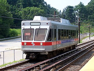
The Norristown High Speed Line (NHSL), currently rebranding as the M, is a 13.4-mile (21.6 km) interurban light rapid transit line in the SEPTA Metro network, running between the 69th Street Transportation Center in Upper Darby and the Norristown Transportation Center in Norristown, Pennsylvania. Service is operated by the Suburban Transit Division of the Southeastern Pennsylvania Transportation Authority. Originally the Philadelphia and Western Railroad line, the line runs entirely on its own right-of-way. By 2020, the Norristown High Speed Line had an average weekday ridership approaching 11,000 passengers.
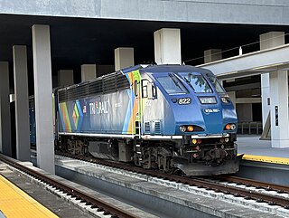
Tri-Rail is a commuter rail service linking Miami, Fort Lauderdale and West Palm Beach in Florida, United States. The Tri prefix in the name refers to the three counties served by the railroad: Palm Beach, Broward, and Miami-Dade. Tri-Rail is managed by the South Florida Regional Transportation Authority (SFRTA) along CSX Transportation's former Miami Subdivision; the line is now wholly owned by the Florida DOT. The 80.0-mile-long (128.7 km) system has 19 stations along the Southeast Florida coast, and connects directly to Amtrak at numerous stations, to Metrorail at the Metrorail Transfer station, Miami Airport station, and MiamiCentral, and to Brightline at MiamiCentral.

The Eurasian Land Bridge, sometimes called the New Silk Road, is the rail transport route for moving freight and passengers overland between Pacific seaports in the Russian Far East and China and seaports in Europe. The route, a transcontinental railroad and rail land bridge, comprises the Trans-Siberian Railway, which runs through Russia and is sometimes called the Northern East-West Corridor, and the New Eurasian Land Bridge or Second Eurasian Continental Bridge, running through China and Kazakhstan. As of November 2007, about one percent of the $600 billion in goods shipped from Asia to Europe each year were delivered by inland transport routes.

North Station is a commuter rail and intercity rail terminal station in Boston, Massachusetts. It is served by four MBTA Commuter Rail lines – the Fitchburg Line, Haverhill Line, Lowell Line, and Newburyport/Rockport Line – and the Amtrak Downeaster intercity service. The concourse is located under the TD Garden arena, with the platforms extending north towards drawbridges over the Charles River. The eponymous subway station, served by the Green Line and Orange Line, is connected to the concourse with an underground passageway.

A rail trail is a shared-use path on a railway right of way. Rail trails are typically constructed after a railway has been abandoned and the track has been removed but may also share the right of way with active railways, light rail, or streetcars, or with disused track. As shared-use paths, rail trails are primarily for non-motorized traffic including pedestrians, bicycles, horseback riders, skaters, and cross-country skiers, although snowmobiles and ATVs may be allowed. The characteristics of abandoned railways—gentle grades, well-engineered rights of way and structures, and passage through historical areas—lend themselves to rail trails and account for their popularity. Many rail trails are long-distance trails, while some shorter rail trails are known as greenways or linear parks.
A Bering Strait crossing is a hypothetical bridge or tunnel that would span the relatively narrow and shallow Bering Strait between the Chukotka Peninsula in Russia and the Seward Peninsula in the U.S. state of Alaska. The crossing would provide a connection linking the Americas and Afro-Eurasia.

Intermodal passenger transport, also called mixed-mode commuting, involves using two or more modes of transportation in a journey. Mixed-mode commuting is often used to combine the strengths of various transportation options. A major goal of modern intermodal passenger transport is to reduce dependence on the automobile as the major mode of ground transportation and increase use of public transport. To assist the traveller, various intermodal journey planners such as Rome2rio and Google Transit have been devised to help travellers plan and schedule their journey.
The Grand Junction Railroad is an 8.55-mile (13.76 km) long railroad in the Boston, Massachusetts, area, connecting the railroads heading west and north from Boston. The line is notable for its railroad bridge over the Charles River that passes under the Boston University Bridge between Boston and Cambridge, Massachusetts.

Port Washington is the terminus of the Long Island Rail Road's Port Washington Branch in Port Washington, New York. The station is located on Main Street, between Haven Avenue and South Bayles Avenue, just west of Port Washington Boulevard, and is 19.9 miles (32 km) from Pennsylvania Station in Midtown Manhattan. A pedestrian bridge exists between the platforms, and is in line with Franklin Avenue, ending at Haven Avenue.

A street running train is a train which runs on a track built on public streets. The rails are embedded in the roadway, and the train shares the street with other users, such as pedestrians, cars and cyclists, thus often being referred to as running in mixed traffic. Tram and light rail systems frequently run on streets, with light rail lines typically separated from other traffic.
Staten Island light rail proposals refer to two projects in the New York City borough of Staten Island. These proposals are among the several light rail projects that have been floated in New York City in recent years. Neither proposal was funded in the Metropolitan Transportation Authority's 2015–2019 Capital Plan, but $4 million was allocated to a study for it.

The Wallkill Valley Rail Trail is a 23.7-mile (38.1 km) rail trail and linear park that runs along the former Wallkill Valley Railroad rail corridor in Ulster County, New York, United States. It stretches from Gardiner through New Paltz, Rosendale and Ulster to the Kingston city line, just south of a demolished, concrete Conrail railroad bridge that was located on a team-track siding several blocks south of the also-demolished Kingston New York Central Railroad passenger station. The trail is separated from the Walden–Wallkill Rail Trail by two state prisons in Shawangunk, though there have been plans to bypass these facilities and to connect the Wallkill Valley Rail Trail with other regional rail-trails. The northern section of the trail forms part of the Empire State Trail.
Saskatchewan has a transportation infrastructure system of roads, highways, freeways, airports, ferries, pipelines, trails, waterways, and railway systems serving a population of approximately 1,132,505 inhabitants year-round.
The New Eurasian Land Bridge, also called the Second or New Eurasian Continental Bridge, is the southern counterpart to the Eurasian Land Bridge and runs through China and Central Asia with possible plans for expansion into South and West Asia. The Eurasian Land Bridge system is important as an overland rail link between China and Europe, with transit between the two via Central Asia and Russia. In the light of the Russian invasion of Ukraine, China halted further investments in the part of the bridge that was planned to go through Russia. After the war began, the Trans-Caspian International Transport Route began to actively develop, which passes through the countries of Central Asia, the Caspian Sea and the countries of the South Caucasus, bypassing Russia.
Greenville Yard is a freight rail yard in the Port of New York and New Jersey. It is located on Upper New York Bay in Jersey City, New Jersey, adjacent and north of Port Jersey. Originally developed in 1904 by the Pennsylvania Railroad, it was later taken over by Conrail. It has been owned by the Port Authority of New York and New Jersey since 2010. It takes its name from the former municipality of Greenville, now part of the city.

The Dumbarton Rail Bridge lies just to the south of the Dumbarton road bridge. Built in 1910, the rail bridge was the first structure to span San Francisco Bay, shortening the rail route between Oakland and San Francisco by 26 miles (42 km). The last freight train traveled over the bridge in 1982, and it has been proposed since 1991 to reactivate passenger train service to relieve traffic on the road bridges, though this would entail a complete replacement of the existing bridge. Part of the western timber trestle approach collapsed in a suspected arson fire in 1998.

On November 8, 2016, Illinois voters approved the Illinois Transportation Taxes and Fees Lockbox Amendment, a legislatively referred constitutional amendment that prohibits lawmakers from using transportation funds for anything other than their stated purpose.