The Green Line is a light rail system run by the Massachusetts Bay Transportation Authority (MBTA) in the Boston, Massachusetts, metropolitan area. It is the oldest Boston rapid transit line, and with tunnel sections dating from 1897, the oldest subway in North America. It runs underground through downtown Boston, and on the surface into inner suburbs via four branches on several radial boulevards. With an average daily weekday ridership of 137,700 in 2019, it is the third most heavily used light rail system in the country. The line was assigned the green color in 1967 during a systemwide rebranding because several branches pass through sections of the Emerald Necklace of Boston.

Kenmore station is a light rail station on the MBTA Green Line, located under Kenmore Square in the Fenway/Kenmore neighborhood of Boston, Massachusetts. The station opened on October 23, 1932 as a one-station extension of the Boylston Street subway to relieve congestion in the square. Kenmore is the primary station for passengers wishing to visit Fenway Park, located one block away.

Davis station is an underground Massachusetts Bay Transportation Authority (MBTA) Red Line rapid transit station located at Davis Square in Somerville, Massachusetts. The accessible station has a single island platform for the Red Line, as well as a dedicated busway on the surface. It opened in 1984 as part of the Red Line Northwest Extension project.
Lechmere Square is located at the intersection of Cambridge Street and First Street in East Cambridge, Massachusetts. It was originally named for the Colonial-era landowner Richard Lechmere, a Loyalist who returned to England at the beginning of the American Revolution. His lands were later seized by the new American government. The shoreline is shown as "Lechmere's Point" on Revolutionary War maps, and was the landing point for British troops en route to the Battles of Lexington and Concord.

Science Park station is an elevated light rail station on the MBTA Green Line. It is located at the Boston end of the Old Charles River Dam at Leverett Circle, near the intersection of Nashua Street and Charles Street. The station is located at the south end of the Lechmere Viaduct, which carries the Green Line over the Charles River. The station is named for the nearby Boston Museum of Science. With 873 daily boardings by a FY 2019 count, Science Park is the least-used fare-controlled station on the Green Line.

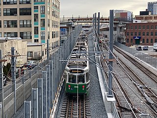
Lechmere station is a Massachusetts Bay Transportation Authority (MBTA) Green Line light rail station in Lechmere Square in East Cambridge, Massachusetts. It is located on the east side of Monsignor O'Brien Highway near First Street, adjacent to the NorthPoint development. The accessible elevated station has a single island platform, with headhouses at both ends. It opened on March 21, 2022, as part of the Green Line Extension (GLX). Lechmere station will initially be served by the Green Line E branch service; D branch service will be added later in 2022.

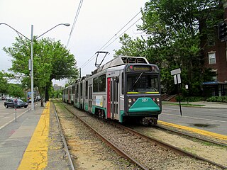
The B branch, also called the Commonwealth Avenue branch or Boston College branch, is a branch of the MBTA Green Line light rail system which operates on Commonwealth Avenue west of downtown Boston, Massachusetts. One of four branches of the Green Line, the B branch runs from Boston College station down the median of Commonwealth Avenue to Blandford Street. There, it enters Blandford Street portal into Kenmore station, where it merges with the C and D branches. The combined services run into the Boylston Street subway and Tremont Street subway to downtown Boston. B branch service has terminated at Government Center since October 2021. Unlike the other branches, the B branch runs solely through the city limits of Boston. The Green Line Rivalry between Boston College and Boston University is named in reference to the B branch, which runs to both universities.

The D branch of the Massachusetts Bay Transportation Authority (MBTA) Green Line, also known as the Highland branch or the Riverside Line, is a light rail line in Boston and the adjacent suburbs of Brookline and Newton. It runs on a grade separated surface right-of-way for 9 miles (14 km) from Riverside station to Fenway station, then shares the Boylston Street Subway and Tremont Street Subway with the other Green Line branches, with a terminus at North Station in downtown Boston. It is the longest and busiest of the four Green Line branches.
The Charles River Dam Bridge, officially the Craigie Bridge, also called Craigie's Bridge or the Canal Bridge, is a six-lane bascule bridge across the Charles River in the West End neighborhood of Boston. The bridge, maintained by the Massachusetts Department of Conservation and Recreation, carries Massachusetts Route 28 next to the Green Line's Lechmere Viaduct. The Museum of Science is located on the dam and nearby piers. Charles River Dam Road connects Leverett Circle in the West End to East Cambridge, but most of the road is fixed, and the asymmetrically sited drawbridge is a short span entirely on the Boston side of the river.
The Urban Ring was a proposed project of the Massachusetts Bay Transportation Authority and the Massachusetts Department of Transportation, to develop new public transportation routes that would provide improved circumferential connections among many existing transit lines that project radially from downtown Boston. The Urban Ring Corridor is located roughly one to two miles from downtown Boston, passing through the Massachusetts cities of Boston, Chelsea, Everett, Medford, Somerville, Cambridge, and Brookline. The project was expected to convert 41,500 car trips to transit trips daily.
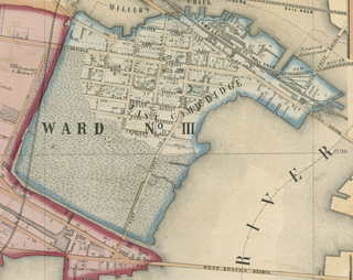
East Cambridge is a neighborhood of Cambridge, Massachusetts. Referred to in modern times as Area 1, East Cambridge is bounded by the Charles River and the Charlestown neighborhood of Boston on the east, the Somerville border on the north, Broadway and Main Street on the south, and the railroad tracks on the west. Most of the streets form a grid aligned with Cambridge Street, which was laid out to directly connect what is now the Charles River Dam Bridge with what in 1809 was the heart of Cambridge, Harvard Square. The northern part of the grid is a roughly six by eight block residential area. Cambridge Street itself is retail commercial, along with Monsignor O'Brien Highway, the Twin Cities Plaza strip mall, and the enclosed Cambridgeside Galleria. Lechmere Square is the transportation hub for the northern side. The southern half of the grid is largely office and laboratory space for hundreds of dot-com companies, research labs and startups associated with MIT, biotechnology firms including Genzyme, Biogen and Moderna, the Athenaeum Press Building, light industry, an NRG Energy power station, and various small businesses. This half of the neighborhood is generally identified with Kendall Square. Along the waterfront are several hotels and taller apartment buildings.
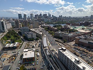
North Point is a neighborhood within the East Cambridge section of Cambridge, Massachusetts. A former railroad yard, the site was originally built by the Boston and Maine Railroad. It is triangular in shape and bound by the MBTA Commuter Rail Fitchburg Line, the Charles River and associated dam with the Lechmere Viaduct, the former Lechmere wetlands, and Millers River remnant that once divided Cambridge and Charlestown, along with the Interstate 93 Northern Expressway viaduct to the northeast.

The Massachusetts Bay Transportation Authority (MBTA) operates heavy-rail, light-rail, and bus transit services in the Boston metropolitan area, collectively referred to as the rapid transit, subway, or the T system.

The Causeway Street elevated was an elevated section of the MBTA Green Line light rail system in Boston, located in the area near North Station. It was in operation from 1912 until 2004, when it was replaced with a new tunnel and underground station on a slightly different alignment.
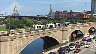
The Lechmere Viaduct is a concrete arch bridge connecting the West End neighborhood of Boston to East Cambridge, Massachusetts. Opened in 1912, the viaduct carries the MBTA's Green Line over the Charles River. It is adjacent to the Charles River Dam Bridge, but structurally separate.
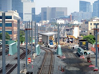
The Green Line Extension (GLX) is a construction project to extend the light rail Massachusetts Bay Transportation Authority (MBTA) Green Line northwest into Somerville and Medford, two inner suburbs of Boston, Massachusetts. The project is opening in two phases in 2022 at a total cost of $2.28 billion. Total ridership on the 4.3-mile (6.9 km) extension is estimated to reach 45,000 one-way trips per day in 2030.

Gilman Square station is an under-construction light rail station on the Massachusetts Bay Transportation Authority (MBTA) Green Line located at Gilman Square in Somerville, Massachusetts. The accessible station has a single island platform serving the two tracks of the Medford Branch, which parallels the Lowell Line. It is planned to open in mid-2022 as part of the Green Line Extension (GLX) and will be served by the E branch.
East Somerville station is an under-construction light rail station on the Massachusetts Bay Transportation Authority (MBTA) Green Line located in southeastern Somerville, Massachusetts. The accessible station has a single island platform serving the two tracks of the Medford Branch, which parallels the Lowell Line. It is planned to open in mid-2022 as part of the Green Line Extension (GLX) and will be served by the E branch.

Lechmere Warehouse was a railroad stop in Woburn, Massachusetts. It served the Lowell Line of the MBTA Commuter Rail system. The station, located in northwestern Woburn away from the residential areas, primarily served reverse commuters working at the adjacent warehouse of the Lechmere department store. It was a flag stop, with certain northbound stops during the morning rush and southbound trains during the evening rush stopping on request.

North Station is an underground MBTA subway station in Boston, Massachusetts. Served by the Massachusetts Bay Transit Authority (MBTA) Green Line and Orange Line, it is connected to the North Station surface terminal used by MBTA Commuter Rail and Amtrak. The station is fully accessible.