Yukon is the smallest and westernmost of Canada's three federal territories. It has the smallest population of any province or territory in Canada, with 35,874 people, although it has the largest city in any of the three territories. Whitehorse is the territorial capital and Yukon's only city.

The City of Fort St. John is a city in northeastern British Columbia, Canada. A member municipality of the Peace River Regional District, the city encompasses a total area of about 22 square kilometres (8.5 sq mi) with 18,609 residents at the 2011 census Located at Mile 47, it is one of the largest cities along the Alaska Highway. Originally established in 1794, as a trading post, Fort St. John is the oldest European-established settlement in present-day British Columbia. Fort St. John is served by the Fort St. John Airport. The municipal slogan is Fort St. John: The Energetic City.
Highway 97 is the longest continuously numbered route in the Canadian province of British Columbia, running 2,081 km (1,293 mi) from the Canada–United States border near Osoyoos in the south to the British Columbia/Yukon boundary in the north at Watson Lake, Yukon. The route takes its number from U.S. Route 97, with which it connects at the international border. The highway was initially designated '97' in 1953.

Fort Nelson is a community in northeast British Columbia, Canada within the Northern Rockies Regional Municipality (NRRM). It held town status prior to February 6, 2009 when it amalgamated with the former Northern Rockies Regional District to form the NRRM, becoming its administrative centre. The NRRM is the first regional municipality in the province.

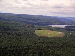
Watson Lake is a town in Yukon, Canada located at mile 635 on the Alaska Highway close to the British Columbia border. The Canada 2016 Census put the population at 790, a drop of 1.5% from 802 in 2011. The town is named for Frank Watson, an American-born trapper and prospector, who settled in the area at the end of the nineteenth century.
The Kaska or Kaska Dena are a First Nations people of the Athabaskan-speaking ethnolinguistic group living mainly in northern British Columbia and the southeastern Yukon in Canada. The Kaska language originally spoken by the Kaska is an Athabaskan language.

The Northern Rockies Regional Municipality (NRRM), formerly the Northern Rockies Regional District (NRRD), and before that the Fort Nelson-Liard Regional District, is a municipality in northeastern British Columbia, Canada. Although portrayed as a regional municipality in its official name, it is actually classified as a district municipality. The NRRM's offices are located in Fort Nelson, formerly an incorporated town that amalgamated with the NRRD on February 6, 2009 to form the NRRM. With the Peace River Regional District as the southern part, it was the northern part of the Peace River-Liard Regional District, which was split into two on October 31, 1987.

The Peace River Country is an aspen parkland region centring on the Peace River in Canada. It extends from northwestern Alberta to the Rocky Mountains in northeastern British Columbia, where a certain portion of the region is also referred to as the Peace River Block.

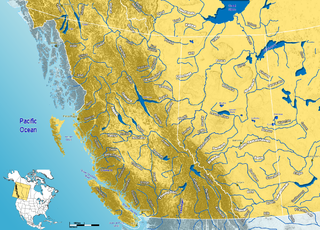
The Rocky Mountain Trench, also known as The Valley of a Thousand Peaks or simply the Trench, is a large valley on the western side of the northern part of North America's Rocky Mountains. The Trench is both visually and cartographically a striking physiographic feature extending approximately 1,600 km (1,000 mi) from Flathead Lake, Montana to the Liard River, just south of the British Columbia-Yukon border near Watson Lake, Yukon. The trench bottom is 3-16 km wide and ranges from 600-900 metres above sea level. The general orientation of the Trench is an almost uniform 150/330 degree geographic north vector and has become convenient as a visual guide for aviators heading north or south.
John McLeod was a Scottish-born explorer of Canada, in his capacity as a fur trader with the North West Company and Hudson's Bay Company. He is remembered primarily for his explorations of several major rivers of the southwestern Northwest Territories, southern Yukon Territory, and northern British Columbia.
Petitot is a river in northern Alberta and British Columbia, Canada. It is a tributary of the Liard River.

The Northwest Territories is a territory in Northern Canada, specifically in Northwestern Canada between Yukon Territory and Nunavut including part of Victoria Island, Melville Island, and other islands on the western Arctic Archipelago. Originally a much wider territory enclosing most of central and northern Canada, the Northwest Territories was created in 1870 from the Hudson's Bay Company's holdings that were sold to Canada from 1869-1870. In addition, Alberta and Saskatchewan were formed from the territory in 1905. In 1999, it was divided again: the eastern portion became the new territory of Nunavut. Yellowknife stands as its largest city and capital. It has a population of 42,800 and has an area of 532,643 sq mi (1,379,540 km2). The current territory lies west of Nunavut, north of latitude 60° north, and east of Yukon.
Yukon is one of Canada's three territories in the country's extreme northwest. Its history of human habitation dates back to the Ice Age, and the original inhabitants are believed to have arrived over 20,000 years ago by migrating over the land bridge from Asia. In the 18th century, Russian explorers began trade with the First Nations people along the Alaskan coast, beginning the establishment of trade relations throughout the region. The famous Klondike Gold Rush began after gold was discovered near Dawson City in 1896. As a result of the influx of people looking for gold, it was made a separate territory in 1898, split off from the Northwest Territories. The second major event in the Yukon's history is the construction of the Alaska Highway during the Second World War, for the transportation of war supplies. Eventually Whitehorse became the largest city in the Yukon, and then the capital in 1953.

The Stikine Country, also referred to as the Stikine District or simply "the Stikine", is one of the historical geographic regions of the Canadian province of British Columbia, located inland from the central Alaska Panhandle and comprising the basin of the Stikine River and its tributaries. The term Stikine–Iskut is also fairly common to describe the area, and references the Iskut River, the Stikine's largest tributary and describable as its south fork.
The Kaska Dena Council is a tribal council formed of five band governments of the Kaska Dena people in northern British Columbia, Yukon Territory, and Northwest Territories, Canada.
Peace River-Liard Regional District was a regional district in northeastern British Columbia, spanning from Tumbler Ridge in the southwest to Lower Post on the northwest, in the angle of British Columbia's borders with Yukon, the Northwest Territories and Alberta. It was created on October 31, 1987 and split into Fort Nelson-Liard Regional District and the Peace River Regional District on October 31, 1987. The Fort Nelson-Liard Regional District was renamed the Northern Rockies Regional District, then made into the Northern Rockies Regional Municipality on May 26, 1999.