
The Metropolitan Area Express (MAX) is a light rail system serving the Portland metropolitan area in the U.S. state of Oregon. Owned and operated by TriMet, it consists of five lines connecting the six sections of Portland; the communities of Beaverton, Clackamas, Gresham, Hillsboro, Milwaukie, and Oak Grove; and Portland International Airport to Portland City Center. Trains run seven days a week with headways between 30 minutes off-peak and three minutes during rush hours. In 2023, MAX recorded an annual ridership of 23,446,700.

The Portland Streetcar is a streetcar system in Portland, Oregon, that opened in 2001 and serves areas surrounding downtown Portland. The 3.9-mile (6.3 km) NS Line runs from Northwest Portland to the South Waterfront via Downtown and the Pearl District. The Loop Service, which opened in September 2012 as the Central Loop, runs from Downtown to the Oregon Museum of Science and Industry via the Pearl District, the Broadway Bridge across Willamette River, the Lloyd District, and the Central Eastside Industrial District and added 3.3 miles (5.3 km) of route. In September 2015 the line was renamed as the Loop Service, with the A Loop traveling clockwise, and the B Loop traveling counterclockwise. The two-route system serves some 20,000 daily riders.

The MAX Blue Line is a light rail line serving the Portland metropolitan area in the U.S. state of Oregon. Operated by TriMet as part of the MAX Light Rail system, it connects Hillsboro, Beaverton, Portland, and Gresham. The Blue Line is the longest in the network; it travels approximately 33 miles (53 km) and serves 48 stations from Hatfield Government Center to Cleveland Avenue. It is the busiest of the five MAX lines, having carried an average 55,370 riders each day on weekdays in September 2018. Service runs for 221⁄2 hours per day from Monday to Thursday, with headways of between 30 minutes off-peak and five minutes during rush hour. It runs later in the evening on Fridays and Saturdays and ends earlier on Sundays.

The MAX Yellow Line is a light rail line serving Portland, Oregon, United States. Operated by TriMet as part of the MAX Light Rail system, it connects North Portland, Portland City Center, and Portland State University (PSU). The line serves 17 stations; it runs north–south from Expo Center station to PSU South/Southwest 6th and College station, interlining with the Green and Orange lines within the Portland Transit Mall. Service runs for 21 hours per day with headways of up to 15 minutes. The Yellow Line is the fourth-busiest service in the MAX system; it carried an average 12,960 riders per weekday in September 2019.

Lloyd Center/Northeast 11th Avenue is a light rail station on the MAX Blue, Green and Red Lines in Portland, Oregon. It is the 10th stop eastbound on the Eastside MAX. The station is located on the 1200 block of Northeast Holladay Street in Lloyd District.
Northeast 7th Avenue is a light rail station on the Blue, Green and Red Lines in Portland, Oregon. It is the 9th stop eastbound on the Eastside MAX.
Rose Quarter Transit Center is a light rail station in the MAX system and a TriMet bus transit center, and is located in the Rose Quarter area of Portland, Oregon, a part of the Lloyd District. It is served by the Blue, Green and Red Lines. It is currently the 7th stop eastbound on the Eastside MAX as well as the first stop after crossing the Willamette River on the Steel Bridge. Two hundred yards west of the station is the Interstate/Rose Quarter station on the MAX Yellow Line.

Mall/Southwest 4th Avenue and Mall/Southwest 5th Avenue were a pair of light rail stations in Portland, Oregon, United States, served by TriMet as part of the MAX Light Rail system. Built into the sidewalk at Southwest Yamhill and Morrison streets between 4th and 5th avenues in downtown Portland, the Mall stations were served by the Blue and Red lines upon closing. They had also been served by the Yellow Line from May 2004 to August 2009.

Pioneer Square South and Pioneer Square North are a pair of light rail stations in Portland, Oregon, United States, served by TriMet as part of the MAX Light Rail system. Situated directly west of the Portland Transit Mall at Pioneer Courthouse Square in downtown Portland, they occupy the sidewalk on Yamhill and Morrison streets between Broadway and 6th Avenue. The stations consist of one side platform each; trains traveling eastbound stop at Pioneer Square South while trains traveling westbound stop at Pioneer Square North.

Like transportation in the rest of the United States, the primary mode of local transportation in Portland, Oregon is the automobile. Metro, the metropolitan area's regional government, has a regional master plan in which transit-oriented development plays a major role. This approach, part of the new urbanism, promotes mixed-use and high-density development around light rail stops and transit centers, and the investment of the metropolitan area's share of federal tax dollars into multiple modes of transportation. In the United States, this focus is atypical in an era when automobile use led many areas to neglect their core cities in favor of development along interstate highways, in suburbs, and satellite cities.
Portland is "an international pioneer in transit orientated developments."
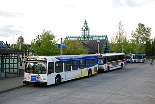
Beaverton Transit Center is a multimodal transport hub in Beaverton, Oregon, United States. Owned and operated by TriMet, it is served by bus, commuter rail, and light rail. The transit center is MAX Light Rail's 15th station eastbound on the Blue Line and 11th station eastbound on the Red Line. It is also the northern terminus of WES Commuter Rail and a hub for bus routes mostly serving the westside communities of the Portland metropolitan area. Beaverton Transit Center is situated on Southwest Lombard Avenue, just north of Southwest Canyon Road in central Beaverton, connected by walkway to Canyon Place Shopping Center. It recorded 9,709 average weekday boardings for all modes in fall 2018, making it TriMet's busiest transit center.

Hillsboro Central/Southeast 3rd Avenue Transit Center, also known as Hillsboro Transit Center, is a light rail station and transit center on the MAX Blue Line in Hillsboro, Oregon. Opened in 1998, the red-brick station is the 19th stop westbound on the Westside MAX, one stop from the western terminus of the line. Physically the largest station on the line, it is located at a former stop of the Oregon Electric Railway and includes artwork honoring the history of the community.

The MAX Green Line is a light rail line serving the Portland metropolitan area in the U.S. state of Oregon. Operated by TriMet as part of the MAX Light Rail system, it connects Portland State University (PSU), Portland City Center, Northeast Portland, Southeast Portland, and Clackamas. The Green Line travels 15 miles (24.1 km) from the PSU South stations to Clackamas Town Center Transit Center and serves 30 stations. It is the only service that interlines with all of the other MAX services, sharing the Portland Transit Mall segment with the Orange and Yellow lines and part of the Eastside MAX segment with the Blue and Red lines. South of Gateway Transit Center, the Green Line branches off to Clackamas Town Center. Service runs for 21 hours on weekdays and 20 hours on weekends with headways of up to 15 minutes. It is the third-busiest line in the system with an average of 13,030 riders per day on weekdays in September 2024.
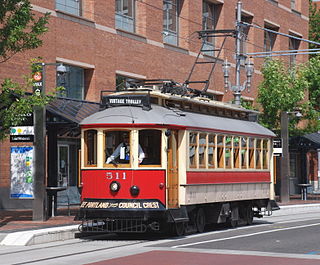
The Portland Vintage Trolley was a heritage streetcar service in Portland, Oregon, United States, that operated from 1991 to 2014. It operated on a portion of the MAX light rail system, and for a brief time also operated on the Portland Streetcar system, in downtown and nearby areas. Service was provided with replicas of a type of Brill streetcar, nicknamed the "Council Crest" cars, which last served Portland in 1950. The service was managed by Vintage Trolley Inc., a non-profit corporation, and the cars were owned and operated by TriMet, Portland's transit agency. For 18 of its 23 years, the service followed a 2.3-mile (3.7 km) section of what is now the MAX Blue Line, between Lloyd Center and the west end of downtown. In September 2009, the route was changed to a 1.5-mile (2.4 km) section of the MAX system, along the transit mall in downtown Portland, from Union Station to Portland State University (PSU).
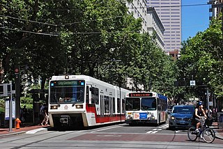
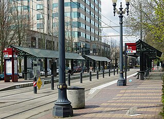
The Portland Transit Mall is a 1.2-mile (1.9 km) public transit corridor that travels north–south through the center of downtown in Portland, Oregon, United States. It comprises a pair of one-way streets—6th Avenue for northbound traffic and 5th Avenue for southbound—along which two of three lanes are restricted to transit buses and light rail vehicles only. As of September 2022, the corridor is served by the Green, Orange, and Yellow lines of MAX Light Rail; Frequent Express; and over a dozen local bus routes, all of which are services of TriMet, the transit agency operating within the Oregon side of the Portland metropolitan area. C-Tran, the transit agency for Clark County, Washington, additionally serves it with two express bus routes—#105 I-5 Express and #164 Fisher’s Landing Express.

PSU South/Southwest 6th and College and PSU South/Southwest 5th and Jackson are a pair of light rail stations on the MAX Green, Orange and Yellow Lines in Portland, Oregon. Together, they serve as the southern passenger terminus—one for departures only and the other for arrivals only—of the Portland Transit Mall MAX line. The stations opened on September 2, 2012.

Providence Park is a light rail station on the MAX Blue and Red lines located in the Goose Hollow neighborhood of Portland, Oregon. It is named after the adjacent stadium, Providence Park. The station primarily serves Providence Park and residential areas around West Burnside Street. The station, consisting of separate eastbound and westbound platforms built into city sidewalks between SW 17th and SW 18th Avenues on SW Yamhill and SW Morrison Streets, opened on August 31, 1997.
The North South Line is a streetcar service of the Portland Streetcar system in Portland, Oregon, United States. Operated by Portland Streetcar, Inc. and TriMet, it travels 4.1 miles (6.6 km) per direction from Northwest 23rd & Marshall to South Lowell & Bond. The line serves 39 stations and connects Portland's Northwest District, Pearl District, downtown, Portland State University (PSU), and South Waterfront. It runs every day of the week between 15 and 18 hours per day and operates on headways of 15 to 20 minutes.

The A and B Loop is a streetcar circle route of the Portland Streetcar system in Portland, Oregon, United States. Operated by Portland Streetcar, Inc. and TriMet, it is made up of two separate services: the 6.1-mile (9.8 km) A Loop, which runs clockwise, and the 6.6-mile (10.6 km) B Loop, which runs counterclockwise. The route travels a loop between the east and west sides of the Willamette River by crossing the Broadway Bridge in the north and Tilikum Crossing in the south.

South Waterfront/South Moody, formerly South Waterfront/Southwest Moody, is a combined light rail and bus station located at 698 Southwest Porter Street in the South Waterfront neighborhood of Portland, Oregon, at the west end of the Tilikum Crossing bridge. It is serviced by the MAX Orange Line and TriMet buses. Portland Streetcar travels through it but does not service it.


