Lidar is a method of spatial measurement using laser.
Lidar may also refer to:
- Daniel Lidar (born 1968), American engineer and academic
- Lidar, character from Tomes & Talismans
Lidar is a method of spatial measurement using laser.
Lidar may also refer to:
Echolocation is the use of sound as a form of navigation.
Lidar is a method for determining ranges by targeting an object or a surface with a laser and measuring the time for the reflected light to return to the receiver. Lidar may operate in a fixed direction or it may scan multiple directions, in which case it is known as lidar scanning or 3D laser scanning, a special combination of 3-D scanning and laser scanning. Lidar has terrestrial, airborne, and mobile applications.
Laz or LAZ may refer to:

Bathymetry is the study of underwater depth of ocean floors, lake floors, or river floors. In other words, bathymetry is the underwater equivalent to hypsometry or topography. The first recorded evidence of water depth measurements are from Ancient Egypt over 3000 years ago.

A radar detector is an electronic device used by motorists to detect if their speed is being monitored by police or law enforcement using a radar gun. Most radar detectors are used so the driver can reduce the car's speed before being ticketed for speeding. In general sense, only emitting technologies, like doppler RADAR, or LIDAR can be detected. Visual speed estimating techniques, like ANPR or VASCAR can not be detected in daytime, but technically vulnerable to detection at night, when IR spotlight is used. There are no reports that piezo sensors can be detected. LIDAR devices require an optical-band sensor, although many modern detectors include LIDAR sensors. Most of today's radar detectors detect signals across a variety of wavelength bands: usually X, K, and Ka. In Europe the Ku band is common as well. The past success of radar detectors was based on the fact that radio-wave beams can not be narrow-enough, so the detector usually senses stray and scattered radiation, giving the driver time to slow down. Based on a focused laser-beam, LIDAR technology does not suffer this shortcoming; however it requires precise aiming. Modern police radars incorporate formidable computing power, producing a minimum number of ultra-short pulses, reusing wide beams for multi-target measurement, which renders most detectors useless. But, mobile Internet allows GPS navigation devices to map police radar locations in real-time. These devices are also often called "radar detectors", while not necessary carrying an RF sensor.
Las or LAS may stand for:
Dial may refer to:

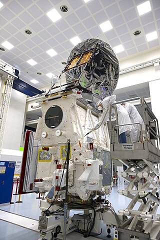
Aeolus, or, in full, Atmospheric Dynamics Mission-Aeolus (ADM-Aeolus), was an Earth observation satellite operated by the European Space Agency (ESA). It was built by Airbus Defence and Space, launched on 22 August 2018, and operated until it was deorbited and re-entered the atmosphere over Antarctica on 28 July 2023. ADM-Aeolus was the first satellite with equipment capable of performing global wind-component-profile observation and provided much-needed information to improve weather forecasting. Aeolus was the first satellite capable of observing what the winds are doing on Earth, from the surface of the planet and into the stratosphere 30 km high.

Stanley is an autonomous car created by Stanford University's Stanford Racing Team in cooperation with the Volkswagen Electronics Research Laboratory (ERL). It won the 2005 DARPA Grand Challenge, earning the Stanford Racing Team a $2 million prize.

CALIPSO was a joint NASA (US) and CNES (France) environmental satellite, built in the Cannes Mandelieu Space Center, which was launched atop a Delta II rocket on April 28, 2006. Its name stands for Cloud-Aerosol Lidar and Infrared Pathfinder Satellite Observations. CALIPSO launched alongside CloudSat.
Ouster may refer to:
Daniel Amihud Lidar is the holder of the Viterbi Professorship of Engineering at the University of Southern California, where he is a professor of electrical engineering, chemistry, physics & astronomy. He is the director and co-founder of the USC Center for Quantum Information Science & Technology (CQIST), the director of the USC-IBM Quantum Innovation Center, as well as scientific director of the USC-Lockheed Martin Quantum Computing Center, notable for his research on control of quantum systems and quantum information processing.
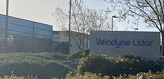
Velodyne Lidar is a Silicon Valley–based lidar technology company, headquartered in San Jose, California. It was spun off from Velodyne Acoustics in 2016. As of July 2020, the company has had about 300 customers. Velodyne Lidar ships sensors to mobility industry customers for testing and commercial use in autonomous vehicles, advanced driver assistance systems, mapping, robotics, infrastructure and smart city applications. In February 2023, the company merged with Ouster.
EarthCARE, nicknamed Hakuryū, is a joint European/Japanese satellite, the sixth of ESA's Earth Explorer Programme. The main goal of the mission is the observation and characterization of clouds and aerosols as well as measuring the reflected solar radiation and the infrared radiation emitted from Earth's surface and atmosphere.

Lidar has a wide range of applications; one use is in traffic enforcement and in particular speed limit enforcement, has been gradually replacing radar since 2000. Current devices are designed to automate the entire process of speed detection, vehicle identification, driver identification and evidentiary documentation.
Autonomous Landing Hazard Avoidance Technology (ALHAT) is technology NASA is developing to autonomously land spacecraft on the Moon, Mars or even an asteroid.
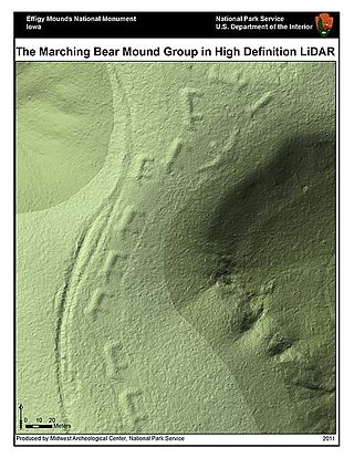
Mahendraparvata is an ancient city of the Khmer Empire era in Cambodia. The existence of the city has been known for decades, but much of it lay concealed by forest and earth. The city was uncovered by an archaeological expedition led by Jean-Baptiste Chevance and Damian Evans in 2012 with the aid of airborne laser scanning technology called LIDAR.
Luminar Technologies Inc. is an American technology company that develops vision-based lidar and machine perception technologies, primarily for self-driving cars. The company's headquarters and main research and development facilities are in Orlando, Florida; a second major office is located in Palo Alto, California.

Guangzhou Xiaopeng Motors Technology Co., Ltd., trading as XPeng Motors, commonly known as XPeng, is a Chinese electric vehicle manufacturer. The company is headquartered in Guangzhou, Guangdong, with offices in Mountain View, California, United States and Munich, Germany. XPeng stock is publicly traded on the New York Stock Exchange and the Hong Kong Stock Exchange.
Ouster, Inc. is an American lidar technology company headquartered in San Francisco, California. It builds high-resolution, digital 3D lidar sensors for use in autonomous vehicles, industrial, robotics, drones, mapping, defense, and security systems.