Related Research Articles

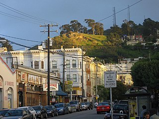
Bernal Heights is a residential neighborhood in southeastern San Francisco, California. The prominent Bernal Heights hill overlooks the San Francisco skyline and features a microwave transmission tower. The nearby Sutro Tower can be seen from the Bernal Heights neighborhood.

The Duboce Triangle is a neighborhood of San Francisco, California, located below Buena Vista Park and between the neighborhoods of the Castro/Eureka Valley, the Mission District, and the Lower Haight.
Cole Valley is a small neighborhood in San Francisco, California. It borders Golden Gate Park to the north, Haight-Ashbury to the northeast, The Castro to the east, and Twin Peaks to the south. Near Kezar Stadium, Cole Valley is the smallest neighborhood in the city.

Crocker-Amazon is a neighborhood in San Francisco that borders the Excelsior District. Crocker-Amazon covers the area south of Mission Street and Geneva Avenue, extending toward suburban Daly City. The neighborhood is adjacent to Crocker-Amazon Park, named after the Charles Crocker land holdings that once made up the area, and Amazon Avenue in the Excelsior. The winding streets of the neighborhood straddle the border between San Francisco and Daly City and largely blend in with the adjacent Daly City neighborhoods of Crocker and Southern Hills.
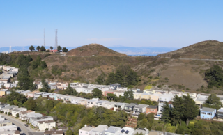
The Twin Peaks are two prominent hills with an elevation of about 925 feet (282 m) located near the geographic center of San Francisco, California. The Twin Peaks are the second and third highest natural points in San Francisco; only 928 foot (283 m) Mount Davidson is higher within city limits.
Eureka Valley is a neighborhood in San Francisco, primarily a quiet residential neighborhood but boasting one of the most visited sub-neighborhoods in the city, The Castro.

Pacific Heights is a neighborhood in San Francisco, California, United States. It has panoramic views of the Golden Gate Bridge, San Francisco Bay, the Palace of Fine Arts, Alcatraz, and the Presidio.
Sequoyah Heights is an affluent, secluded neighborhood in the Oakland Hills, in Oakland, California. The neighborhood has several architecturally prominent 1920s and 1930s houses, surrounding the Sequoyah Country Club and golf course. It overlooks the Interstate 580 above the former Oak Knoll Naval Hospital, and offers views of San Francisco.

Diamond Heights is a neighborhood in central San Francisco, California, roughly bordered by Diamond Heights Boulevard and Noe Valley to the north and east and Glen Canyon Park to the south and west. It is built on three hills: Red Rock Heights on the northwest, Gold Mine Hill in center, and Fairmount Heights on the southeast.

Seal Rock is a group of small rock formation islands in the Lands End area of the Outer Richmond District in western San Francisco, California. They are located just offshore in the Pacific Ocean, at the north end of the Ocean Beach, near the Cliff House and Sutro Baths ruins.

Schoolhouse Creek is a creek which flows through the city of Berkeley, California in the San Francisco Bay Area.
Katherine Delmar Burke School, commonly known as Burke's, is an independent girls' school for kindergarten through eighth grade, located in the Sea Cliff neighborhood of San Francisco, California, United States, near Lincoln Park. Until 1975 it also included a high school. It was founded in 1908 by Katherine Delmar Burke and was named Miss Burke's School.
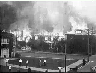
The 1923 Berkeley, California, fire was a conflagration that consumed some 640 structures, including 584 houses in the densely built neighborhoods north of the campus of the University of California in Berkeley, California, on September 17, 1923.

Cathedral Hill is a neighborhood and a hill, in the Western Addition district of San Francisco, California.

Corona Heights is a neighborhood in San Francisco, California, just north of Market Street and Eureka Valley. Corona Heights is often considered part of the Castro and Upper Market areas.

Laurel Heights is a neighborhood of San Francisco, California. It is located to the south of the Presidio of San Francisco and east of the Richmond District. It is bordered by Geary Boulevard and the University of San Francisco campus to the south, Arguello Boulevard to the west, California Street to the north and Presidio Avenue to the east.

Nob Hill is a neighborhood of San Francisco, California, United States that is known for its numerous luxury hotels and historic mansions. Nob Hill has historically served as a center of San Francisco's upper class. Nob Hill is among the highest-income neighborhoods in the United States, as well as one of the most desirable and expensive real estate markets in the country. Prior to Covid-19, it was the most expensive real estate market per metre squared, narrowly beating Monte Carlo, although it has since fallen heavily. It was the only place in the United States so far where market price per square metre exceeded the average yearly salary in the country.
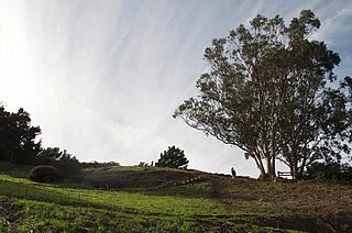
Billy Goat Hill, San Francisco is the easternmost peak in the San Miguel Range located in the Glen Park neighborhood in San Francisco, California.

Kite Hill is a city park and natural area in the Castro district of San Francisco, California. At an elevation of 350 feet, the 2.87 acre park is named for its gusty winds. The natural area includes a panoramic view of San Francisco.