Transformation may refer to:

Neolithic architecture refers to structures encompassing housing and shelter from approximately 10,000 to 2,000 BC, the Neolithic period. In southwest Asia, Neolithic cultures appear soon after 10,000 BC, initially in the Levant and from there into the east and west. Early Neolithic structures and buildings can be found in southeast Anatolia, Syria, and Iraq by 8,000 BC with agriculture societies first appearing in southeast Europe by 6,500 BC, and central Europe by ca. 5,500 BC (of which the earliest cultural complexes include the Starčevo-Koros, Linearbandkeramic, and Vinča.

Bicycle-friendly policies and practices help some people feel more comfortable about traveling by bicycle with other traffic. The level of bicycle-friendliness of an environment can be influenced by many factors including town planning and cycling infrastructure decisions. A stigma towards people who ride bicycles and fear of cycling is a social construct that needs to be fully understood when promoting a bicycle friendly culture.

Rio is a town in the suburbs of Patras and a former municipality in Achaea, West Greece, Greece. Since the 2011 local government reform it is part of the municipality Patras, of which it is a municipal unit. The municipal unit has an area of 98.983 km2. The municipal unit had a population of 14,622 in 2011. The campus of the University of Patras and the Casino Rio is located in Rio.
Constantinos A. Doxiadis, often cited as C. A. Doxiadis, was a Greek architect and urban planner. During the 1960s, he was the lead architect and planner of Islamabad, which was to serve as the new capital city of Pakistan. He was later known as the father of ekistics, which concerns the multi-aspect science of human settlements.

The linear city is an urban plan for an elongated urban formation that was proposed by Arturo Soria y Mata in 1882. The city would consist of a series of functionally specialized parallel sectors. Generally, the city would run parallel to a river and be built so that the dominant wind would blow from the residential areas to the industrial strip. The sectors of a linear city would be:
- a purely segregated zone for railway lines,
- a zone of production and communal enterprises, with related scientific, technical and educational institutions,
- a residential zone, including a band of social institutions, a band of residential buildings and a "children's band",
- a park zone,
- an agricultural zone with gardens and state-run farms.

Coolock is a large suburban area, centred on a village, on Dublin city's Northside in Ireland. Coolock is crossed by the Santry River, a prominent feature in the middle of the district, with a linear park and ponds. The Coolock suburban area encompasses parts of three Dublin postal districts: Dublin 5, Dublin 13 and Dublin 17.

Dimini is a village near the city of Volos, in Thessaly, in Magnesia. It was the seat of the municipality of Aisonia. The name Aisonia dates back to ancient times and it is the westernmost place in the Volos area. The Dimini area contains both a Mycenean settlement and a Neolithic settlement. The Neolithic settlement in Dimini was discovered near the end of the 19th century and was first excavated by the archaeologists Christos Tsountas and Valerios Stais.

Magnitogorsk is an industrial city in Chelyabinsk Oblast, Russia, on the eastern side of the extreme southern extent of the Ural Mountains by the Ural River. Its population is 407,775 (2010 Census).
Ribbon development refers to the building of houses along the routes of communications radiating from a human settlement. The resulting linear settlements are clearly visible on land use maps and aerial photographs, giving cities and the countryside a particular character. Such development generated great concern in the United Kingdom during the 1920s and the 1930s as well as in numerous other countries during the decades since.

A response spectrum is a plot of the peak or steady-state response of a series of oscillators of varying natural frequency, that are forced into motion by the same base vibration or shock. The resulting plot can then be used to pick off the response of any linear system, given its natural frequency of oscillation. One such use is in assessing the peak response of buildings to earthquakes. The science of strong ground motion may use some values from the ground response spectrum for correlation with seismic damage.
Earthquake engineering is an interdisciplinary branch of engineering that designs and analyzes structures, such as buildings and bridges, with earthquakes in mind. Its overall goal is to make such structures more resistant to earthquakes. An earthquake engineer aims to construct structures that will not be damaged in minor shaking and will avoid serious damage or collapse in a major earthquake. A properly engineered structure does not necessarily have to be extremely strong or expensive. It has to be properly designed to withstand the seismic effects while sustaining an acceptable level of damage.
A video game with nonlinear gameplay presents players with challenges that can be completed in a number of different sequences. Each player may take on only some of the challenges possible, and the same challenges may be played in a different order. Conversely, a video game with linear gameplay will confront a player with a fixed sequence of challenges: every player faces every challenge and has to overcome them in the same order.

A greenway is usually a shared-use path along a strip of undeveloped land, in an urban or rural area, set aside for recreational use or environmental protection. Greenways are frequently created out of disused railways, canal towpaths, utility or similar rights of way, or derelict industrial land. Greenways also can also be linear parks, and can serve as wildlife corridors. The path's surface may be paved and often serves multiple users: walkers, runners, bicyclists, skaters and hikers. A characteristic of greenways, as defined by the European Greenways Association, is "ease of passage": that is that they have "either low or zero gradient", so that they can be used by all "types of users, including mobility impaired people".
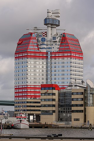
The Lilla Bommen (Building) named after the surrounding location of Lilla Bommen, commonly referred to as Läppstiftet , is an 86m, 22 floor building housing office, networking and restaurant spaces in Gothenburg, Sweden. The building’s distinct post-modern architectural style, popularly referred to as “The Lipstick” due to its distinctive red and white colour schematic, was erected on the banks of Göta River in 1989 by Skanska Property West AB. The 32000 sqm office space which houses over 900 office workers, is a popular tourist destination for its top-floor lookout, Götheborgs Utkiken and restaurants such as the Restuarang Läppstiftet, has contributed to the landmark status of the building in the Central Gothenburg skyline.

A linear settlement is a settlement or group of buildings that is formed in a long line. Many of these settlements are formed along a transport route, such as a road, river, or canal. Others form due to physical restrictions, such as coastlines, mountains, hills or valleys. Linear settlements may have no obvious centre.
A linear park is a type of park that is significantly longer than it is wide. These linear parks are strips of public land running along canals, rivers, streams, defensive walls, electrical lines, or highways and shorelines. Examples of linear parks include everything from wildlife corridors to riverways to trails, capturing the broadest sense of the word. Other examples include rail trails, which are disused railroad beds converted for recreational use by removing existing structures. Commonly, these linear parks result from the public and private sectors acting on the dense urban need for open green space. Linear parks stretch through urban areas, coming through as a solution for the lack of space and need for urban greenery. They also effectively connect different neighborhoods in dense urban areas as a result, and create places that are ideal for activities such as jogging or walking. Linear parks may also be categorized as greenways. In Australia, a linear park along the coast is known as a foreshoreway. When being designed, linear parks appear unique as they are planned around the public's opinion of how the space will affect them.
The Line is a linear smart city under construction in Saudi Arabia in Neom, Tabuk Province, which is designed to have no cars, streets or carbon emissions. The 170-kilometre-long (110 mi) city is part of Saudi Vision 2030 project, which Saudi Arabia claims will create around 460,000 jobs and add an estimated $48 billion to the country's GDP. The Line is planned to be the first development of a $500 billion project in Neom. The city's plans anticipate a population of 9 million. Excavation work had started along the entire length of the project by October 2022.