This is a list of Rijksmonuments in Groningen.
Description | Original function? | Built | Architect | Location | Coordinates? | No.? | Image |
---|---|---|---|---|---|---|---|
Filadelfia | ![]() | c. 1800 | Broerstraat 2-4 | 53°19′20″N6°51′22″E / 53.32217°N 6.85598°E | 8207 | ![]() | |
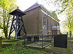
Liberated Reformed church (Synagogue before 1945) | ![]() | 1801 | Broerstraat 6 | 53°19′20″N6°51′22″E / 53.32231°N 6.85601°E | 8208 | ||
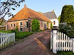
Lime-kiln | ![]() | 2nd half 19th century | Dijkhuizenweg 28 | 53°19′12″N6°50′58″E / 53.32005°N 6.84935°E | 8209 | ||
Left basement building under transverse gable roof with on the right a low floor | ![]() | 13th century (core) | Dijkstraat 30 | 53°19′14″N6°51′27″E / 53.32061°N 6.85762°E | 8210 | ![]() | |
Building with low floor and second floor under deep gable roof with rear house and gazebo | ![]() | 14th or 15th century (core) 18th century (rear house) | Dijkstraat 32 | 53°19′14″N6°51′28″E / 53.32062°N 6.85789°E | 8211 | ![]() | |
Corner Building under transverse gable roof against a top-gable roof with narrow Groninger-style windows | ![]() | Dijkstraat 34 | 53°19′14″N6°51′28″E / 53.32062°N 6.85789°E | 8212 | ![]() | ||
Five bays wide, large building under high hipped roof with corner chimneys and a big cornice | ![]() | 1750-1800 | Gouden Pand 1 | 53°19′16″N6°51′22″E / 53.32113°N 6.8562°E | 8214 | ![]() | |
Building under transverse gable roof with narrow carved consoles to the fascia | ![]() | possibly Middle ages (core) | Gouden Pand 5 | 53°19′16″N6°51′23″E / 53.32122°N 6.85626°E | 8215 | ![]() | |
Building with curious pui under transverse gable roof with narrow carved consoles to the fascia | ![]() | possibly Middle ages 19th century (pui) | Gouden Pant 7 | 53°19′17″N6°51′22″E / 53.32128°N 6.85623°E | 8216 | ![]() | |
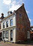
![]() | ![]() |
Description | Original function? | Built | Architect | Location | Coordinates? | No.? | Image |
---|---|---|---|---|---|---|---|
Artificial dwelling hill | ![]() | Late Antiquity/Middle ages | Garreweersterpolder | 53°18′41″N6°48′39″E / 53.31142°N 6.81075°E | 45151 | ![]() | |
Artificial dwelling hill | ![]() | Late Antiquity/Middle ages | Garreweersterpolder | 53°18′40″N6°48′53″E / 53.31102°N 6.81464°E | 45152 | ![]() |
Description | Original function? | Built | Architect | Location | Coordinates? | No.? | Image |
---|---|---|---|---|---|---|---|
Artificial dwelling hill | ![]() | Late Antiquity | Jukwerderweg/Christophoripad | 53°20′06″N6°50′49″E / 53.33493°N 6.84688°E | 45150 | ![]() | |
Artificial dwelling hill | ![]() | Late Antiquity/Middle ages | Jukwerd | 53°20′03″N6°50′49″E / 53.33429°N 6.84702°E | 45153 | ![]() |
Description | Original function? | Built | Architect | Location | Coordinates? | No.? | Image |
---|---|---|---|---|---|---|---|
Artificial dwelling hill | ![]() | probably Middle ages | Laskwerd | 53°17′37″N6°50′38″E / 53.29354°N 6.84387°E | 45149 | ![]() |
Description | Original function? | Built | Architect | Location | Coordinates? | No.? | Image |
---|---|---|---|---|---|---|---|
Mauritiuskerk | ![]() | c. 1306 restored 1949-1951 | Marsumerweg 12 | 53°20′23″N6°52′30″E / 53.33963°N 6.87503°E | 8252 | ||
Artificial dwelling hill | ![]() | Late Antiquity/Middle ages | Marsum | 53°20′29″N6°52′24″E / 53.34146°N 6.87327°E | 45154 | ![]() | |
Artificial dwelling hill | ![]() | Late Antiquity/Middle ages | Marsumerweg | 53°20′22″N6°52′32″E / 53.33951°N 6.87555°E | 45157 | ![]() | |
Artificial dwelling hill | ![]() | Late Antiquity/Middle ages | Marsumerweg | 53°20′24″N6°52′33″E / 53.34011°N 6.87585°E | 45253 | ![]() |
Description | Original function? | Built | Architect | Location | Coordinates? | No.? | Image |
---|---|---|---|---|---|---|---|
Reformed church | ![]() | 1225-1250 probably 1838 (partially rebuilt) 1910 (Flèche) 1964-1968 (restoration) | Opwierderweg 122 | 53°18′48″N6°52′25″E / 53.31327°N 6.87352°E | 8253 | ![]() | |
Artificial dwelling hill | ![]() | c. Late Antiquity | Opwierderweg | 53°18′48″N6°52′28″E / 53.31347°N 6.87435°E | 45254 | ![]() |
Description | Original function? | Built | Architect | Location | Coordinates? | No.? | Image |
---|---|---|---|---|---|---|---|
Reformed pastorage (De Weem) | ![]() | 1554 | Pastorielaan 1 | 53°19′24″N6°52′12″E / 53.32325°N 6.87002°E | 9254 | ![]() | |
Large farm with house with framed entrance and a large, front-side-shortened cap | ![]() | Pastorielaan 7 | 53°19′26″N6°52′13″E / 53.32397°N 6.87024°E | 8255 | ![]() | ||
Reformed church with bellchair | ![]() | 1783 (rebuilt) | possibly G. Bonsema | Pastorielaan 5 | 53°19′26″N6°52′09″E / 53.32394°N 6.86919°E | 9256 | ![]() |
Artificial dwelling hill | ![]() | c. Late Antiquity | Pastorielaan | 53°19′26″N6°52′09″E / 53.32383°N 6.86917°E | 45255 | ![]() |