This is a list of Sites of Community Importance designated by the Ministry of Agriculture, Food and Environment .
| ID | Name | Coordinates | Image |
|---|---|---|---|
| ES0000214 | Espacio marino de Tabarca (official name: Espacio marino de Tabarca) Other names: n/a | 38°11′23″N0°29′06″W / 38.1898°N 0.4851°W |  |
| ES0000447 | Espacio marino de Orpesa y Benicàssim (official name: Espacio marino de Orpesa y Benicàssim) Other names: n/a | 40°02′37″N0°05′29″E / 40.0437°N 0.0913°E | |
| ES5212005 | L'Almadrava (official name: L'Almadrava) Other names: n/a | 38°52′38″N0°03′46″E / 38.8771°N 0.0629°E |  |
| ES5222007 | Alguers de Borriana-Nules-Moncofa (official name: Alguers de Borriana-Nules-Moncofa) Other names: n/a | 39°47′16″N0°07′07″W / 39.7877°N 0.1185°W | |
| ES5310108 | Área marina del cap Martinet (official name: Área marina del cap Martinet) Other names: n/a | 38°55′58″N1°30′39″E / 38.9327°N 1.5107°E | |
| ES6110009 | Fondos Marinos de Punta Entinas-Sabinar (official name: Fondos Marinos de Punta Entinas-Sabinar) Other names: n/a | 36°40′42″N2°42′03″W / 36.6782°N 2.7007°W |  |
| ES6110010 | Fondos Marinos Levante Almeriense (official name: Fondos Marinos Levante Almeriense) Other names: n/a | 37°13′02″N1°46′30″W / 37.2173°N 1.7751°W |  |
| ES6110019 | Arrecifes de Roquetas de Mar (official name: Arrecifes de Roquetas de Mar) Other names: n/a | 36°47′02″N2°35′15″W / 36.7838°N 2.5876°W | |
| ES6120032 | Estrecho Oriental (official name: Estrecho Oriental) Other names: n/a | 36°06′50″N5°17′47″W / 36.1139°N 5.2965°W | |
| ES6170036 | Fondos Marinos de La Bahía de Estepona (official name: Fondos Marinos de La Bahía de Estepona) Other names: n/a | 36°24′56″N5°08′08″W / 36.415533°N 5.13545°W | |
| ES6170037 | El Saladillo - Punta de Baños (official name: El Saladillo - Punta de Baños) Other names: n/a | 36°25′56″N5°00′57″W / 36.432333°N 5.01575°W |  |
| ES6200048 | Valles submarinos del Escarpe de Mazarrón (official name: Valles submarinos del Escarpe de Mazarrón) Other names: n/a | 37°29′05″N0°57′31″W / 37.4848°N 0.9586°W |  |
| ES6300001 | Chafarinas Islands (official name: Islas Chafarinas) Other names: n/a | 35°11′00″N2°25′35″W / 35.1833°N 2.4264°W |  |
| ES7010016 | Área marina de La Isleta (official name: Área marina de La Isleta) Other names: n/a | 28°11′00″N15°22′53″W / 28.1833°N 15.3814°W |  |
| ES7010017 | Franja marina de Mogán (official name: Franja marina de Mogán) Other names: n/a | 27°46′36″N15°45′31″W / 27.7766°N 15.7585°W |  |
| ES7010020 | Sebadales de La Graciosa (official name: Sebadales de La Graciosa) Other names: n/a | 29°13′22″N13°30′06″W / 29.2228°N 13.5018°W |  |
| ES7010021 | Sebadales de Guasimeta (official name: Sebadales de Guasimeta) Other names: n/a | 28°55′56″N13°35′26″W / 28.9323°N 13.5905°W | |
| ES7010022 | Sebadales de Corralejo (official name: Sebadales de Corralejo) Other names: n/a | 28°42′31″N13°49′32″W / 28.7087°N 13.8256°W |  |
| ES7010035 | Playa de Sotavento de Jandía (official name: Playa de Sotavento de Jandía) Other names: n/a | 28°10′02″N14°11′42″W / 28.1673°N 14.1949°W |  |
| ES7010037 | Bahía del Confital (official name: Bahía del Confital) Other names: n/a | 28°08′16″N15°26′32″W / 28.1378°N 15.4421°W |  |
| ES7010048 | Bahía de Gando (official name: Bahía de Gando) Other names: n/a | 27°55′22″N15°22′27″W / 27.9228°N 15.3742°W |  |
| ES7010053 | Playa del Cabrón (official name: Playa del Cabrón) Other names: n/a | 27°51′16″N15°22′49″W / 27.8545°N 15.3804°W | 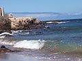 |
| ES7010056 | Sebadales de Playa del Inglés (official name: Sebadales de Playa del Inglés) Other names: n/a | 27°44′47″N15°33′09″W / 27.7463°N 15.5526°W |  |
| ES7010066 | Costa de Sardina del Norte (official name: Costa de Sardina del Norte) Other names: n/a | 28°09′14″N15°42′26″W / 28.154°N 15.7073°W | |
| ES7011002 | Cagafrecho (official name: Cagafrecho) Other names: n/a | 28°54′48″N13°39′47″W / 28.9134°N 13.6631°W | |
| ES7011005 | Sebadales de Güigüí (official name: Sebadales de Güigüí) Other names: n/a | 27°57′10″N15°52′19″W / 27.9528°N 15.872°W |  |
| ES7020017 | Franja marina Teno-Rasca (official name: Franja marina Teno-Rasca) Other names: n/a | 28°11′36″N16°53′30″W / 28.1932°N 16.8918°W |  |
| ES7020057 | Mar de Las Calmas (official name: Mar de Las Calmas) Other names: n/a | 27°39′31″N18°03′16″W / 27.6587°N 18.0544°W | 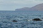 |
| ES7020116 | Sebadales del sur de Tenerife (official name: Sebadales del sur de Tenerife) Other names: n/a | 28°01′15″N16°35′12″W / 28.0209°N 16.5868°W | |
| ES7020117 | Cueva marina de San Juan (official name: Cueva marina de San Juan) Other names: n/a | 28°10′22″N16°48′25″W / 28.1729°N 16.8069°W | |
| ES7020120 | Sebadal de San Andrés (official name: Sebadal de San Andrés) Other names: n/a | 28°29′46″N16°11′24″W / 28.496°N 16.1901°W | |
| ES7020122 | Franja marina de Fuencaliente (official name: Franja marina de Fuencaliente) Other names: n/a | 28°32′08″N17°53′52″W / 28.5356°N 17.8979°W |  |
| ES7020123 | Franja marina Santiago-Valle Gran Rey (official name: Franja marina Santiago-Valle Gran Rey) Other names: n/a | 28°01′37″N17°17′38″W / 28.027°N 17.2938°W | |
| ES7020124 | Costa de Garafía (official name: Costa de Garafía) Other names: n/a | 28°51′00″N17°53′18″W / 28.8501°N 17.8883°W |  |
| ES7020125 | Costa de los Órganos (official name: Costa de los Órganos) Other names: n/a | 28°12′39″N17°17′35″W / 28.2107°N 17.293°W | |
| ES7020126 | Costa de San Juan de la Rambla (official name: Costa de San Juan de la Rambla) Other names: n/a | 28°24′23″N16°38′07″W / 28.4063°N 16.6354°W | 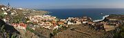 |
| ES7020128 | Sebadales de Antequera (official name: Sebadales de Antequera) Other names: n/a | 28°31′34″N16°08′03″W / 28.5261°N 16.1341°W | 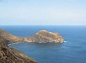 |
| ES90ATL01 | Le Danois Bank (official name: El Cachucho) Other names: n/a | 44°02′32″N4°51′00″W / 44.0423°N 4.85°W | |
| ESZZ12001 | Banco de Galicia (official name: Banco de Galicia) Other names: n/a | 42°44′02″N11°47′43″W / 42.7338°N 11.7952°W | |
| ESZZ12002 | Volcanes de fango del Golfo de Cádiz (official name: Volcanes de fango del Golfo de Cádiz) Other names: n/a | 36°12′31″N7°08′35″W / 36.2085°N 7.143°W | |
| ESZZ12003 | Sistema de cañones submarinos de Avilés (official name: Sistema de cañones submarinos de Avilés) Other names: n/a | 43°52′16″N6°06′00″W / 43.8712°N 6.1001°W | |
| ESZZ15001 | Banco de la Concepción (official name: Banco de la Concepción) Other names: n/a | 30°00′27″N12°40′43″W / 30.0074°N 12.6785°W | |
| ESZZ15002 | Espacio marino del oriente y sur de Lanzarote-Fuerteventura (official name: Espacio marino del oriente y sur de Lanzarote-Fuerteventura) Other names: n/a | 28°00′17″N14°04′10″W / 28.0046°N 14.0695°W | |
| ESZZ16001 | Sistema de cañones submarinos occidentales del Golfo de León (official name: Sistema de cañones submarinos occidentales del Golfo de León) Other names: n/a | 42°23′36″N3°26′14″E / 42.3934°N 3.4371°E | |
| ESZZ16002 | Canal de Menorca (official name: Canal de Menorca) Other names: n/a | 39°52′41″N3°37′21″E / 39.878°N 3.6224°E | |
| ESZZ16003 | Sur de Almería - Seco de los Olivos (official name: Sur de Almería - Seco de los Olivos) Other names: n/a | 36°38′49″N2°30′03″W / 36.647°N 2.5009°W | |
| ESZZ16004 | Espacio marino de Illes Columbretes (official name: Espacio marino de Illes Columbretes) Other names: n/a | 39°52′47″N0°37′07″E / 39.8796°N 0.6187°E | |
| ESZZ16005 | Espacio marino de Alborán (official name: Espacio marino de Alborán) Other names: n/a | 35°56′16″N2°54′57″W / 35.9377°N 2.9159°W | |
| ESZZ16006 | Espacio marino de Ifac (official name: Espacio marino de Ifac) Other names: n/a | 38°38′59″N0°04′45″E / 38.6496°N 0.0793°E | |
| ESZZ16007 | Espacio marino de la Marina Alta (official name: Espacio marino de la Marina Alta) Other names: n/a | 38°43′41″N0°12′26″E / 38.728°N 0.2071°E | |
| ESZZ16008 | Espacio marino del Cabo de les Hortes (official name: Espacio marino del Cabo de les Hortes) Other names: n/a | 38°24′00″N0°22′34″W / 38.3999°N 0.376°W | |
| ESZZ16009 | Espacio marino de Cabo Roig (official name: Espacio marino de Cabo Roig) Other names: n/a | 37°57′37″N0°40′49″W / 37.9603°N 0.6804°W | |
| ESZZ16010 | Espacio marino del entorno de Illes Columbretes (official name: Espacio marino del entorno de Illes Columbretes) Other names: n/a | 39°52′36″N0°40′43″E / 39.8766°N 0.6785°E | |