This is a list of Sites of Community Importance in the Region of Murcia .
| ID | Name | Coordinates | Image |
|---|---|---|---|
| ES0000173 | Sierra Espuña (official name: Sierra Espuña) Other names: n/a | 37°51′54″N1°33′28″W / 37.865°N 1.5578°W | 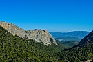 |
| ES0000175 | Salinas y Arenales de San Pedro del Pinatar (official name: Salinas y Arenales de San Pedro del Pinatar) Other names: n/a | 37°48′32″N0°45′37″W / 37.8089°N 0.7603°W | 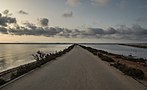 |
| ES6200001 | Calblanque, Monte de las Cenizas y Peña del Águila (official name: Calblanque, Monte de las Cenizas y Peña del Águila) Other names: n/a | 37°36′09″N0°46′56″W / 37.6025°N 0.7822°W |  |
| ES6200002 | Carrascoy y El Valle (official name: Carrascoy y El Valle) Other names: n/a | 37°51′52″N1°12′13″W / 37.864444°N 1.203611°W | 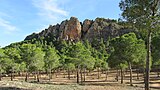 |
| ES6200003 | Sierra de La Pila (official name: Sierra de La Pila) Other names: n/a | 38°15′25″N1°13′50″W / 38.2569°N 1.2306°W |  |
| ES6200004 | Sierras y Vega Alta del Segura y Ríos Alhárabe y Moratalla (official name: Sierras y Vega Alta del Segura y Ríos Alhárabe y Moratalla) Other names: n/a | 38°15′37″N1°42′26″W / 38.2603°N 1.7072°W |  |
| ES6200005 | Humedal del Ajauque y Rambla Salada (official name: Humedal del Ajauque y Rambla Salada) Other names: n/a | 38°06′36″N1°05′24″W / 38.1099°N 1.0901°W | 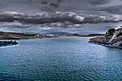 |
| ES6200006 | Espacios Abiertos e Islas del Mar Menor (official name: Espacios Abiertos e Islas del Mar Menor) Other names: n/a | 37°39′53″N0°49′04″W / 37.664722°N 0.817778°W | 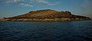 |
| ES6200007 | Islas e Islotes del Litoral Mediterráneo (official name: Islas e Islotes del Litoral Mediterráneo) Other names: n/a | 37°43′36″N0°42′22″W / 37.7267°N 0.7061°W | 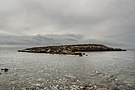 |
| ES6200008 | Sierra Salinas (official name: Sierra Salinas) Other names: n/a | 38°29′36″N1°02′15″W / 38.493333°N 1.0375°W |  |
| ES6200009 | Sierra de El Carche (official name: Sierra de El Carche) Other names: n/a | 38°25′44″N1°10′08″W / 38.428889°N 1.1688889999999998°W | 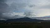 |
| ES6200010 | Cuatro Calas (official name: Cuatro Calas) Other names: n/a | 37°23′02″N1°37′51″W / 37.3839°N 1.6308°W |  |
| ES6200011 | Sierra de las Moreras (official name: Sierra de las Moreras) Other names: n/a | 37°34′53″N1°23′22″W / 37.5814°N 1.3894°W | 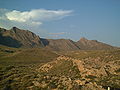 |
| ES6200012 | Calnegre (official name: Calnegre) Other names: n/a | 37°30′23″N1°26′22″W / 37.506389°N 1.439444°W | 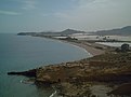 |
| ES6200013 | Cabezo Gordo (official name: Cabezo Gordo) Other names: n/a | 37°48′11″N0°54′21″W / 37.803056°N 0.905833°W |  |
| ES6200014 | Saladares del Guadalentín (official name: Saladares del Guadalentín) Other names: n/a | 37°44′47″N1°23′19″W / 37.746389°N 1.388611°W |  |
| ES6200015 | La Muela y Cabo Tiñoso (official name: La Muela y Cabo Tiñoso) Other names: n/a | 37°35′35″N1°09′00″W / 37.5931°N 1.15°W | 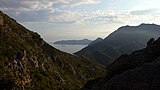 |
| ES6200016 | Revolcadores (official name: Revolcadores) Other names: n/a | 38°02′49″N2°16′50″W / 38.0469°N 2.2806°W | 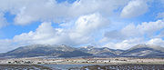 |
| ES6200017 | Sierra de Villafuerte (official name: Sierra de Villafuerte) Other names: n/a | 38°08′32″N2°09′04″W / 38.1422°N 2.1511°W |  |
| ES6200018 | Sierra de la Muela (official name: Sierra de la Muela) Other names: n/a | 38°14′26″N1°58′38″W / 38.2406°N 1.9772°W | |
| ES6200019 | Sierra del Gavilán (official name: Sierra del Gavilán) Other names: n/a | 38°07′32″N1°54′49″W / 38.1256°N 1.9136°W | |
| ES6200020 | Casa Alta-Salinas (official name: Casa Alta-Salinas) Other names: n/a | 37°53′16″N2°02′32″W / 37.8879°N 2.0422°W | |
| ES6200021 | Sierra de Lavia (official name: Sierra de Lavia) Other names: n/a | 37°57′48″N1°45′22″W / 37.9633°N 1.7561°W | |
| ES6200022 | Sierra del Gigante (official name: Sierra del Gigante) Other names: n/a | 37°45′56″N1°58′37″W / 37.7656°N 1.9769°W | |
| ES6200023 | Sierra de la Tercia (official name: Sierra de la Tercia) Other names: n/a | 37°44′33″N1°37′16″W / 37.7425°N 1.6211°W |  |
| ES6200024 | Cabezo de Roldán (official name: Cabezo de Roldán) Other names: n/a | 37°35′32″N1°02′25″W / 37.5922°N 1.0403°W |  |
| ES6200025 | Sierra de la Fausilla (official name: Sierra de la Fausilla) Other names: n/a | 37°34′01″N0°54′28″W / 37.5669°N 0.9078°W |  |
| ES6200026 | Sierra de Ricote-La Navela (official name: Sierra de Ricote-La Navela) Other names: n/a | 38°08′15″N1°23′03″W / 38.1375°N 1.3842°W | 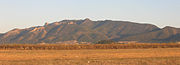 |
| ES6200027 | Sierra de Abanilla (official name: Sierra de Abanilla) Other names: n/a | 38°13′31″N1°00′32″W / 38.2253°N 1.0089°W | |
| ES6200028 | Río Chícamo (official name: Río Chícamo) Other names: n/a | 38°10′41″N1°02′27″W / 38.178056°N 1.040833°W |  |
| ES6200029 | Franja Litoral Sumergida de la Región de Murcia (official name: Franja Litoral Sumergida de la Región de Murcia) Other names: n/a | 37°35′00″N0°45′11″W / 37.5833°N 0.7531°W |  |
| ES6200030 | Mar Menor (official name: Mar Menor) Other names: n/a | 37°44′05″N0°47′14″W / 37.7347°N 0.7872°W |  |
| ES6200031 | Cabo Cope (official name: Cabo Cope) Other names: n/a | 37°25′50″N1°29′15″W / 37.430556°N 1.4875°W |  |
| ES6200032 | Minas de la Celia (official name: Minas de la Celia) Other names: n/a | 38°27′43″N1°28′20″W / 38.4619°N 1.4721°W |  |
| ES6200033 | Cueva de las Yeseras (official name: Cueva de las Yeseras) Other names: n/a | 38°04′48″N1°01′50″W / 38.0801°N 1.0306°W | |
| ES6200034 | Lomas del Buitre y Río Luchena (official name: Lomas del Buitre y Río Luchena) Other names: n/a | 37°46′39″N1°51′34″W / 37.7775°N 1.8594°W |  |
| ES6200035 | Sierra de Almenara (official name: Sierra de Almenara) Other names: n/a | 37°32′44″N1°34′24″W / 37.5456°N 1.5733°W |  |
| ES6200036 | Sierra del Buey (official name: Sierra del Buey) Other names: n/a | 38°32′09″N1°12′47″W / 38.535833°N 1.213056°W | |
| ES6200037 | Sierra del Serral (official name: Sierra del Serral) Other names: n/a | 38°31′17″N1°05′20″W / 38.521389°N 1.088889°W | |
| ES6200038 | Cuerda de la Serrata (official name: Cuerda de la Serrata) Other names: n/a | 38°00′45″N2°00′37″W / 38.0125°N 2.0103°W | |
| ES6200039 | Cabezo de la Jara y Rambla de Nogalte (official name: Cabezo de la Jara y Rambla de Nogalte) Other names: n/a | 37°31′12″N1°52′55″W / 37.52°N 1.8819°W |  |
| ES6200040 | Cabezos del Pericón (official name: Cabezos del Pericón) Other names: n/a | 37°40′13″N1°07′19″W / 37.670278°N 1.121944°W | |
| ES6200041 | Rambla de la Rogativa (official name: Rambla de la Rogativa) Other names: n/a | 38°06′25″N2°13′41″W / 38.1069°N 2.2281°W | |
| ES6200042 | Yesos de Ulea (official name: Yesos de Ulea) Other names: n/a | 38°09′14″N1°16′00″W / 38.153889°N 1.266667°W | |
| ES6200043 | Río Quípar (official name: Río Quípar) Other names: n/a | 38°09′55″N1°39′09″W / 38.1653°N 1.6525°W |  |
| ES6200044 | Sierra de los Victorias (official name: Sierra de los Victorias) Other names: n/a | 37°42′08″N1°07′29″W / 37.7022°N 1.1247°W | |
| ES6200045 | Río Mula y Pliego (official name: Río Mula y Pliego) Other names: n/a | 38°02′08″N1°21′28″W / 38.0355°N 1.3578°W |  |
| ES6200046 | Sierra de En medio (official name: Sierra de En medio) Other names: n/a | 37°29′28″N1°48′30″W / 37.4911°N 1.8083°W |  |
| ES6200047 | Sierra de la Torrecilla (official name: Sierra de la Torrecilla) Other names: n/a | 37°39′58″N1°46′25″W / 37.6661°N 1.7736°W |  |


