Related Research Articles

Portland is the most populous city in the U.S. state of Maine and the county seat of Cumberland County. Portland's population was 68,408 in April 2020. The Greater Portland metropolitan area has a population of approximately 550,000 people. Historically tied to commercial shipping, the marine economy, and light industry, Portland's economy in the 21st century relies mostly on the service sector. The Port of Portland is the second-largest tonnage seaport in the New England area as of 2019.

Falmouth is a town in Cumberland County, Maine, United States. The population was 12,444 at the 2020 census. It is part of the Portland–South Portland–Biddeford, Maine metropolitan statistical area.

South Portland is a city in Cumberland County, Maine, United States, and is the fourth-most populous city in the state, incorporated in 1898. At the 2020 census, the city population was 26,498. Known for its working waterfront, South Portland is situated on Portland Harbor and overlooks the skyline of Portland and the islands of Casco Bay. Due to South Portland's close proximity to air, marine, rail, and highway transportation options, the city has become a center for retail and industry in the region. The Maine Mall, the largest shopping mall in the state, is located in South Portland. It is also a designated Tree City USA community.

A swing bridge is a movable bridge that can be rotated horizontally around a vertical axis. It has as its primary structural support a vertical locating pin and support ring, usually at or near to its center of gravity, about which the swing span can then pivot horizontally as shown in the animated illustration to the right.

Casco Bay is an inlet of the Gulf of Maine on the coast of Maine in the United States. The National Oceanic and Atmospheric Administration's chart for Casco Bay marks the dividing line between the bay and the Gulf of Maine as running from Bald Head on Cape Small in Phippsburg west-southwest to Dyer Point in Cape Elizabeth. The city of Portland and the Port of Portland are on Casco Bay's western edge.

The Delaware Memorial Bridge is a dual-span suspension bridge crossing the Delaware River. The toll bridges carry Interstate 295 and U.S. Route 40 and is also the link between Delaware and New Jersey. The bridge was designed by the firm of Howard, Needles, Tammen & Bergendoff with consulting help from engineer Othmar Ammann, whose other designs include the George Washington Bridge and the Verrazzano-Narrows Bridge.

The Fore River is a short horn-shaped estuary, approximately 5.7 miles (9.2 km) long, separating Portland and South Portland in Maine in the United States. Many of the port facilities of the Portland harbor are along the estuary, which is formed just southwest of Portland by the confluence of several creeks. The estuary was initially known as Levett's River, so named by the first English settler of the Casco Bay region, Capt. Christopher Levett. But shortly afterwards, the estuary came to have the name by which it is known today.
Veterans' Memorial Bridge may refer to:

The Million Dollar Bridge was a bascule bridge built in 1916 which carried traffic on Route 77 over the Fore River in Maine between Portland and South Portland.
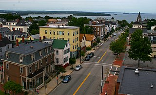
Munjoy Hill is a neighborhood and prominent geographical feature of Portland, Maine. It is located east of downtown and south of East Deering. In the nineteenth and twentieth centuries, the neighborhood had a large Irish and Italian American population.
The Casco Bay Bridge is a bascule bridge that spans the Fore River, connecting South Portland and Portland, Maine, United States. The bridge carries four lanes of State Route 77, a bike lane in each direction, and a pedestrian sidewalk on the east side of the span.

The Julie N. is a Liberian tanker that was involved in an oil spill occurring on the Fore River on 27 September 1996 in Portland, Maine. The 560 foot (170 m) ship was carrying over 200,000 barrels (32,000 m3) of heating oil and was headed towards a docking station in South Portland to unload its contents.

Tukey's Bridge is a bridge connecting the neighborhoods of Munjoy Hill and East Deering in Portland, Maine. It is part of Interstate 295, U.S. Route 1, and Washington Avenue.
Portland, Maine, is home to many neighborhoods.
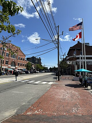
Commercial Street is a downtown street in the Old Port of Portland, Maine, United States. It is part of U.S. Route 1A. It became the Old Port's waterfront in the early 20th century, replacing Fore Street, after land was reclaimed from the waters of Casco Bay and the Fore River.
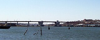
Veterans Memorial Bridge is a bridge in Maine, United States, connecting the cities of Portland and South Portland. The bridge spans the Fore River and is part of U.S. Route 1. The original Veterans Memorial Bridge was built in 1954, and was described as 'rapidly deteriorating' prior to its demolition. Designated a top infrastructure priority by Maine state government, a new bridge was built between 2010 and 2012. General contractor Reed & Reed, of Woolwich, was awarded the rebuilding contractor. Reed & Reed estimated the new bridge would stand for a century.

Martin's Point Bridge spans the Presumpscot River in Maine, United States, near the river’s mouth with Casco Bay. It connects Falmouth Foreside, at Mackworth Point, in the north, to the East Deering neighborhood of Portland, at Martin's Point, in the south. 1,300 feet (400 m) in length, it carries vehicular and pedestrian traffic of U.S. Route 1. The bridge is two lanes, including a bicycle lane in each, with a pedestrian lane on the eastern side. A similar plan for the western side of the bridge was abandoned.

Portland and Yarmouth Electric Railway was an electric trolleycar service that ran along the coast between Portland and Yarmouth, Maine, from 1898 and 1933. Described in 1901 as the "new electric road", Yarmouth was "now a closer neighbor [to Portland] than ever before" because of the railway's advent.
References
- ↑ Forecaster, The (June 13, 2014). "New Martin's Point Bridge opens".
- ↑ "Tukey's Bridge, Portland, ca. 1900". Maine Memory Network.
- ↑ Hurowitz, Noah (June 28, 2012). "New Maine Veterans Memorial Bridge opens between Portland and South Portland". Bangor Daily News . Retrieved 20 July 2018.