Transport in Chile is mostly by road. The far south of the country is not directly connected to central Chile by road, and water transport also plays a part there. The railways were historically important in Chile, but now play a relatively small part in the country's transport system. Because of the country's geography and long distances between major cities, aviation is also important.

Izabal is one of the 22 departments of Guatemala. Its coastal areas form part of the homeland of the Garifuna people.

Los Lagos Region is one of Chile's 16 regions, which are first order administrative divisions, and comprises four provinces: Chiloé, Llanquihue, Osorno and Palena. The region contains the country's second largest island, Chiloé, and the second largest lake, Llanquihue. Its capital is Puerto Montt; other important cities include Osorno, Castro, Ancud, and Puerto Varas. The mainland portion of Los Lagos Region south of Reloncaví Sound is considered part of Patagonia.

Río Negro is a Chilean city and commune in Osorno Province, Los Lagos Region. The city is located 38 km south of Osorno and 6 km west of Route 5. It has an area of 1,266 km² and a population of 14,732 inhabitants.

The Los Ríos Region is one of Chile's 16 regions, the country's first-order administrative divisions. Its capital is Valdivia. It began to operate as a region on October 2, 2007, having been created by subdividing the Los Lagos Region in southern Chile. It consists of two provinces: Valdivia and the newly created Ranco Province, which was formerly part of Valdivia Province.

The Camino Real de Tierra Adentro was a Spanish 2,560-kilometre-long (1,590 mi) road between Mexico City and San Juan Pueblo, New Mexico, USA, that was used from 1598 to 1882. It was the northernmost of the four major "royal roads" that linked Mexico City to its major tributaries during and after the Spanish colonial era.

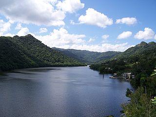
Dos Bocas Lake is a lake located in the municipalities of Arecibo and Utuado on the island of Puerto Rico. The lake was created from 1937 until it was completed in 1942 with the construction of the Dos Bocas Dam, by the Puerto Rico Electric Power Authority for a hydroelectric power plant. The building of the dam was a New Deal project. It also serves as one of the island's potable water reservoirs. In recent years, silt has accumulated in the lake causing capacity to shrink. Silt has also made some portions of the land inaccessible by boat.

Guajataca River is a river in Lares, Puerto Rico. It is located on the northwest coast of the island. It flows from the south and drains into the Atlantic Ocean. The name was given by the original Taino inhabitants prior to the arrival of Christopher Columbus.

The Indio River is a river of Vega Baja and Morovis in Puerto Rico. Indio River has mogotes on either side. Indio River meets Cibuco River. The river is quick to rise and causes flooding when there is heavy rain.
Tlatlaya is one of 125 municipalities of the State of Mexico in Mexico. The municipal seat is the town of Tlatlaya which is the eleventh largest town in the municipality. The word “Tlatlaya” means when the hearth is black and red.

Tejupilco is a municipality in the State of Mexico, Mexico, located approximately 100 kilometres (62 mi) southwest of the state capital Toluca, along Federal Highway 134. Its municipal seat is Tejupilco de Hidalgo. The municipality has a total area of about 1,327 km2 (512 sq mi), with a contrasting topography ranging from deep ravines and canyons to high ridges; the highest elevation within the municipality reaches some 1,117 metres (3,660 ft) asl. The 2005 census recorded a population of 62,547 inhabitants.
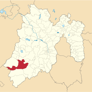
Luvianos is a small town and municipality located in the southwest of the State of Mexico. It gained municipal status in 2000. People can access Luvianos by driving Federal Road 134 south from Toluca, and then take a detour about 25 minutes north of Tejupilco. The name is derived from a hacienda what was established during colonial times.

Real is one of the 31 barrios of the municipality of Ponce, Puerto Rico. Along with Anón, Coto Laurel, Guaraguao, Quebrada Limón, Marueño, and San Patricio, and the coastal barrios of Canas and Capitanejo, Real is one of the municipality's nine bordering barrios. It borders the municipality of Juana Diaz. It was founded in 1878.

Lake Cerrillos is a man-made lake located in barrio Maragüez, Ponce, Puerto Rico. The lake was finished in 1992 by the U.S. Army Corps of Engineers. The main purposes of the reservoir are flood control, water supply, and recreation. There is a variety of fish available for fishing such as largemouth bass, bluegills, catfish and tilapias. The 1993 Central American and Caribbean Games that were held in Ponce staged the canoeing competitions in this lake. It was used in the 2010 Central American and Caribbean Games for the sports of Canoeing, Rowing. The lake is the main drinking water source for the city of Ponce.
The southern coast of Chile presents a large number of fjords and fjord-like channels from the latitudes of Cape Horn to Reloncaví Estuary. Some fjords and channels are important navigable channels providing access to ports like Punta Arenas, Puerto Chacabuco and Puerto Natales.

The 2007 Parapan American Games, officially the III Parapan American Games, were a major international multi-sport event for athletes with disabilities, celebrated in the tradition of the Parapan American Games as governed by the Americas Paralympic Committee, held from August 12 to 19, 2007 in Rio de Janeiro, Brazil. Organized by the Rio de Janeiro Organizing Committee (CO-Rio) and the Brazilian Paralympic Committee (BPC), it marked the first time that the Parapan American Games were staged in the same city and followed directly after the Pan American Games.


