Related Research Articles
Saitama Prefecture is a landlocked prefecture of Japan located in the Kantō region of Honshu. Saitama Prefecture has a population of 7,338,536 and has a geographic area of 3,797 km2. Saitama Prefecture borders Tochigi Prefecture and Gunma Prefecture to the north, Nagano Prefecture to the west, Yamanashi Prefecture to the southwest, Tokyo to the south, Chiba Prefecture to the southeast, and Ibaraki Prefecture to the northeast.

Kawaguchi is a city located in Saitama Prefecture, Japan. As of 1 January 2021, the city had an estimated population of 607,373 in 293,582 households and a population density of 9800 persons per km². The total area of the city is 61.95 square kilometres (23.92 sq mi). It is the Greater Tokyo Area's 8th most populated city, and second largest in Saitama Prefecture.

Tokorozawa is a city located in Saitama Prefecture, Japan. As of 1 February 2021, the city had an estimated population of 344,194 in 163,675 households and a population density of 4800 persons per km². The total area of the city is 72.11 square kilometres (27.84 sq mi).

Warabi is a city located in Saitama Prefecture, Japan. As of 1 January 2021, the city had an estimated population of 75,697 in 39,563 households and a population density of 15,000 persons per km². The total area of the city is 5.11 square kilometres (1.97 sq mi). Warabi has the smallest area of any municipality in Japan, and highest population density outside of the special wards of Tokyo.

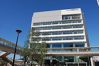
Urawa is one of ten wards of the city of Saitama, in Saitama Prefecture, Japan, and is located in the northeastern part of the city. Urawa-ku is the governmental center of Saitama City and houses most of the city's administrative offices including the city hall, as well as the offices of Saitama Prefectural government. Also, there are several newspaper branch offices and three broadcasting stations.

Kita is a special ward in the Tokyo Metropolis in Japan. The English translation of its Japanese self-designation is City of Kita. The ward was founded on March 15, 1947.

Ōmiya is one of ten wards of the city of Saitama, in Saitama Prefecture, Japan, and is located in the northeastern part of the city. As of 1 March 2021, the ward had an estimated population of 119,298 and a population density of 9,300 persons per km². Its total area was 12.80 square kilometres (4.94 sq mi). Although Urawa-ku is the governmental center of Saitama City, Ōmiya-ku is the most active commercial and business centre in both Saitama City and Saitama Prefecture thanks to its transport infrastructure, especially railways connected at Ōmiya Station.

Saitama University is a Japanese national university located in a suburban area of Sakura-ku, Saitama City, capital of Saitama Prefecture in Tokyo Metropolitan Area.

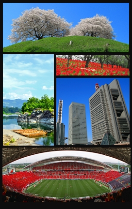
Saitama is the capital and the most populous city of Saitama Prefecture, Japan. Its area incorporates the former cities of Urawa, Ōmiya, Yono and Iwatsuki. It is a city designated by government ordinance. Being in the Greater Tokyo Area and lying 15 to 30 kilometres north of central Tokyo, many of its residents commute into Tokyo. As of 1 February 2021, the city had an estimated population of 1,324,854, and a population density of 6,093 people per km². Its total area is 217.43 square kilometres (83.95 sq mi).

Kita-ku is one of ten wards of the city of Saitama, in Saitama Prefecture, Japan, and is located in the northwestern part of the city. As of 1 March 2021, the ward had an estimated population of 148,935 and a population density of 8800 persons per km². Its total area was 16.86 square kilometres (6.51 sq mi).
The Saitama Broncos is a men's professional basketball club based in Tokorozawa, Saitama Prefecture, Japan. It calls the whole prefecture home and its main home arenas are Tokorozawa Municipal Gymnasium and Saitama Super Arena in Chūō-ku, Saitama City. It competes in the B.League.

Kita-Toda Station is a passenger railway station located in the city of Toda, Saitama, Japan, operated by the East Japan Railway Company.
Minami-ku is one of ten wards of the city of Saitama, in Saitama Prefecture, Japan, and is located in the southern part of the city. As of 1 March 2021, the ward had an estimated population of 192,143 and a population density of 14,000 persons per km². Its total area was 13.82 square kilometres (5.34 sq mi).
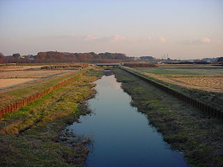
Minuma or Minuma Rice Paddies is an area of paddy fields and other agricultural fields along the Minuma Irrigational Canal in Saitama Prefecture, Japan. The area encompasses 1260 hectares and straddles across five wards of the city of Saitama. Despite its close proximity to major urban areas such as Saitama-Shintoshin Station and Ōmiya Station, idyllic scenery consisting of paddy fields, farmlands, forests and rivers still remains.

Midori-ku is one of ten wards of the city of Saitama, in Saitama Prefecture, Japan, and is located in the southeastern part of the city. As of 1 March 2021, the ward had an estimated population of 129,705 and a population density of 4,900 persons per km². Its total area was 26.44 square kilometres (10.21 sq mi).

Kawaguchi-motogō Station is a passenger railway station on the Saitama Rapid Railway Line in Kawaguchi, Saitama, Japan, operated by the third-sector railway operator Saitama Railway Corporation.

Minami-hatogaya Station is a passenger railway station on the Saitama Rapid Railway Line in the city of Kawaguchi, Saitama, Japan, operated by the third sector railway operator Saitama Railway Corporation.

Hatogaya Station is a passenger railway station on the Saitama Rapid Railway Line in the city of Kawaguchi, Saitama, Japan, operated by the third sector railway operator Saitama Railway Corporation.
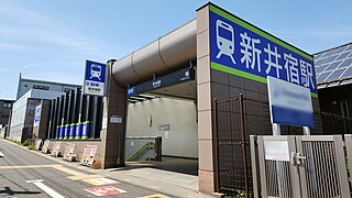
Araijuku Station is a passenger railway station on the Saitama Rapid Railway Line in the city of Kawaguchi, Saitama, Japan, operated by the third sector railway operator Saitama Railway Corporation.
Tozuka-angyō Station is a passenger railway station on the Saitama Rapid Railway Line in the city of Kawaguchi, Saitama, Japan, operated by the third sector railway operator Saitama Railway Corporation.