
This is a list of hospitals in Ponce, Puerto Rico . Both, public and private hospitals are listed. General as well as specialized hospitals are listed.
This is a list of hospitals in Ponce, Puerto Rico . Both, public and private hospitals are listed. General as well as specialized hospitals are listed.
The following table lists hospitals by their year of founding, that is, their year of opening. A listing sorted by any of the other fields can be obtained by clicking on the header of the field. For example, clicking on "Barrio" will sort hospitals by their barrio location.
| No. | Name | Photo | Barrio | Location | Type | Year Opened | Year Current Structure Built | Floors | Beds | Architectural style |
|---|---|---|---|---|---|---|---|---|---|---|
| 1 | Hospital Damas | 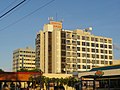 | Canas Urbano | PR-2R, Ponce Bypass WB | Teaching Hospital | 1863 | 1973 | 10 | 331 | Modern |
| 2 | Hospital Valentín Tricoche (closed) | 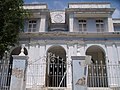 | Segundo | C. Bertoly & C. Tricoche | General hospital (closed) | 1873 | 1873 | 3 | N/A | Neoclassical |
| 3 | Centro Médico Episcopal San Lucas | 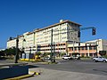 | Machuelo Abajo | PR-14 WB, Av. Tito Castro | General Hospital | 1907 | 2007 | 7 | 287 | Modern |
| 4 | Hospital Metropolitano Dr. Pila |  | Canas Urbano | Av. Las Américas WB | General hospital | 1925 | 1983 | 5 | 210 | Modern |
| 5 | Hospital Oncológico Andrés Grillasca |  | Machuelo Abajo | PR-14 WB, Av. Tito Castro | Cancer | 1946 | 1955 | 2 | 86 | Modern |
| 6 | Hospital San Cristóbal [note 1] | | Coto Laurel | PR-506 NB and PR-52 WB | General hospital | 1983 [1] | 2006? [1] | UNK | 138 [2] | Modern |
Key:
Av. = Avenida (avenue)
C. = Calle (street)
NB = Northbound
SB = Southbound
WB = Westbound
EB = Eastbound
Unk = Unknown
N/A = Not applicable