The Upper Peninsulaof Michigan—also known as Upper Michigan or colloquially the U.P. or Yoop—is the northern and more elevated of the two major landmasses that make up the U.S. state of Michigan; it is separated from the Lower Peninsula by the Straits of Mackinac. It is bounded primarily by Lake Superior to the north, separated from the Canadian province of Ontario at the east end by the St. Marys River, and flanked by Lake Huron and Lake Michigan along much of its south. Although the peninsula extends as a geographic feature into the state of Wisconsin, the state boundary follows the Montreal and Menominee rivers and a line connecting them.

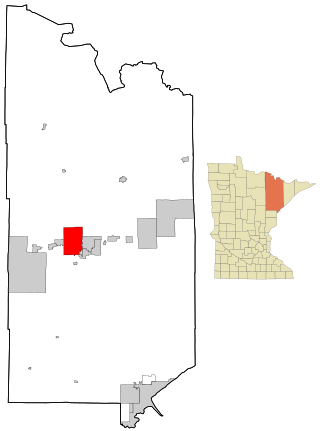
Mountain Iron is a city in Saint Louis County, Minnesota, United States, in the heart of the Mesabi Range. The population was 2,878 at the 2020 census.

The Mesabi Iron Range is a mining district and mountain range in northeastern Minnesota following an elongate trend containing large deposits of iron ore. It is the largest of four major iron ranges in the region collectively known as the Iron Range of Minnesota. First described in 1866, it is the chief iron ore mining district in the United States. The district is located largely in Itasca and Saint Louis counties. It has been extensively worked since 1892, and has seen a transition from high-grade direct shipping ores through gravity concentrates to the current industry exclusively producing iron ore (taconite) pellets. Production has been dominantly controlled by vertically integrated steelmakers since 1901, and therefore is dictated largely by US ironmaking capacity and demand.

The Iron Range is collectively or individually a number of elongated iron-ore mining districts around Lake Superior in the United States and Canada. Much of the ore-bearing region lies alongside the range of granite hills formed by the Giants Range batholith. These cherty iron ore deposits are Precambrian in the Vermilion Range and middle Precambrian in the Mesabi and Cuyuna ranges, all in Minnesota. The Gogebic Range in Wisconsin and the Marquette Iron Range and Menominee Range in Michigan have similar characteristics and are of similar age. Natural ores and concentrates were produced from 1848 until the mid-1950s, when taconites and jaspers were concentrated and pelletized, and started to become the major source of iron production.
Iron Mountain may refer to:

Acid mine drainage, acid and metalliferous drainage (AMD), or acid rock drainage (ARD) is the outflow of acidic water from metal mines and coal mines.

Red Mountain is a long ridge running southwest-northeast and dividing Jones Valley from Shades Valley south of Birmingham, Alabama. It is part of the Ridge-and-Valley region of the Appalachian Mountains. The Red Mountain Formation of hard Silurian rock strata lies exposed in several long crests, and was named "Red Mountain" because of the rust-stained rock faces and prominent seams of red hematite iron ore. The mountain was the site of several mines that supplied iron ore to Birmingham's iron furnaces. Most of Birmingham's television and radio stations have transmission towers located on Red Mountain.

Zouérat is the largest town in northern Mauritania and the capital of the Tiris Zemmour region, with an approximate population of 44,649 (2013). It lies at the eastern end of the Mauritania Railway to Nouadhibou.

Thabazimbi is an iron mining town in the Limpopo province of South Africa. The town is at the feet of the Ysterberg and is surrounded by the Witfonteinrand and Boshofberg with the majestic Kransberg in the background. The name Thabazimbi means mountain of iron because of the large iron ore reef that was discovered in 1919 by J. H. Williams. The mine boasts one of the largest mining shafts in Africa. More than two million tonnes of ore are mined every year and hauled by train to Mittal's iron and steel works. The railway line from Rustenburg reached the area in the 1930s and full scale iron and steel production began. The town was proclaimed in 1953. Kumba Iron Ore, previously Kumba Resources, is now the principal operator of the iron ore mine.

Eagle Mountain is a ghost town in the California desert in Riverside County founded in 1948 by industrialist Henry J. Kaiser. The town is located at the entrance of the now-defunct Eagle Mountain iron mine, once owned by the Southern Pacific Railroad, then Kaiser Steel, and located on the southeastern corner of Joshua Tree National Park. The town's fully integrated medical care system, similar to other Kaiser operations in California, was the genesis of the modern-day Kaiser Permanente health maintenance organization. Eagle Mountain is accessible by Kaiser Road from California State Route 177, twelve miles (19 km) north of Desert Center, midway between Indio and the California/Arizona state line along Interstate 10.

The Colorado Fuel and Iron Company (CF&I) was a large steel conglomerate founded by the merger of previous business interests in 1892. By 1903 it was mainly owned and controlled by John D. Rockefeller and Jay Gould's financial heirs. While it came to control many plants throughout the country, its main plant was a steel mill on the south side of Pueblo, Colorado, and was the city's main industry for most of its history. From 1901 to 1912, Colorado Fuel and Iron was one of the Dow Jones Industrials. The steel-market crash of 1982 led to the decline of the company. After going through several bankruptcies, the company was acquired by Oregon Steel Mills in 1993, and changed its name to Rocky Mountain Steel Mills. In January 2007, Rocky Mountain Steel Mills, along with the rest of Oregon Steel's holdings, were acquired by EVRAZ Group, a Russian steel corporation, for $2.3 billion.

Tahawus was a village in the Town of Newcomb, Essex County, New York, United States. It is now a ghost town situated in the Adirondack Park. Tahawus is located in Essex County within the unpopulated northern area designated to the town of Newcomb. Tahawus was the site of major mining and iron smelting operations in the 19th century. Although standing as recently as 2005, the last mining facilities have since been demolished and removed.
Rittenhouse Gap is the name of a human settlement in Longswamp Township in Berks County, Pennsylvania, United States, situated at 40°28′04″N75°37′47″W.

Iron Mountain Mine, also known as the Richmond Mine at Iron Mountain, is a mine near Redding in Northern California, US. Geologically classified as a "massive sulfide ore deposit", the site was mined for iron, silver, gold, copper, zinc, quartz, and pyrite intermittently from the 1860s until 1963. The mine is the source of extremely acidic mine drainage which also contains large amounts of zinc, copper, and cadmium. One of America's most toxic waste sites, it has been listed as a federal Superfund site since 1983.

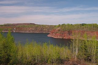
Mountain Iron Mine is a former mine in Mountain Iron, Minnesota, United States. Opened in 1892, it was the first mine on the Mesabi Range, which has proved to be the largest iron ore deposit ever discovered in the United States. Mining operations at the site ceased in 1956. The bottom of the open-pit mine has filled with water but its dimensions are readily visible. The city maintains an overlook in Mountain Iron Locomotive Park.

The Gogebic Range is an elongated area of iron ore deposits located within a range of hills in northern Michigan and Wisconsin just south of Lake Superior. It extends from Lake Namakagon in Wisconsin eastward to Lake Gogebic in Michigan, or almost 80 miles. Though long, it is only about a half mile wide and forms a crescent concave to the southeast. The Gogebic Range includes the communities of Ironwood in Michigan, plus Mellen and Hurley in Wisconsin.

Grandfontaine is a commune in the Bas-Rhin department in Grand Est in north-eastern France. In the German dialect of the region it is called Grosbrun.

Spring Creek Debris Dam is an earthfill dam on Spring Creek, a tributary of the Sacramento River, in Shasta County in the U.S. state of California. Completed in 1963, the dam, maintained by the U.S. Bureau of Reclamation, serves primarily to collect severe acid mine drainage stemming from the Iron Mountain Mine. The dam forms the Spring Creek Reservoir, less than 1 mile (1.6 km) long. Spring Creek and South Fork Spring Creek flow into the reservoir from a 16-square-mile (41 km2) watershed. The dam is directly upstream from the city of Keswick, California and the Keswick Reservoir. The operation is part of the Trinity River Division of the Central Valley Project.

Pilot Knob is located in the Arcadia Valley of Iron County, Missouri, between the towns of Ironton and Pilot Knob. Pilot Knob, so named because of its distinctive shape and prominent position, reaches an elevation of 1,470 feet (450 m) rising 581 feet (177 m) above the Arcadia Valley floor and has a large deposit of iron ore in its upper regions. Pilot Knob is a peak in the St. Francois Mountains.


